NCN Route(s) 465, 47, & 88 — Between Pontywaun, Newport & Sirhowy Parc

We have 28 unique cycle routes alone in the South East Valleys, but these inter-connected routes between Pontywaun, Newport & Sirhowy Parc are certainly the ones I ride the most.
OVERVIEW
14 Locks, Newport & Sirhowy Parc
Date: 15 November 2023
Distance: 43.6 mi. / 70.17 km
Elevation: +1,869 ft / -1,835 ft
Duration: 7 hrs, 50 mins.
Distance: 43.6 mi. / 70.17 km
Elevation: +1,869 ft / -1,835 ft
Duration: 7 hrs, 50 mins.
Quite simply, this is my "go-to" cycle route. When I want to get a quick 30-40 mile ride in before the weather turns nasty or as a simple training ride before a longer ride; this will most often be my route of choice.
It's an easy ride too. I generally drop down the valley from Newbridge to make my way to Abercarn and then Pontywaun. There I join the traffic-free cycle path that follows the Crumlin Arm of the Monmouthshire & Brecon Canal all the way down to Newport.
Once in Newport, I then join NCN Route 88 to continue traveling traffic-free along the riverfront. This short section then snakes down alongside the River Usk to join NCN Route 4 near the legendary Newport Transporter Bridge.
If you're wondering why this ride took me nearly seven hours to complete, it is simply because I stopped to take photographs a lot. [ Fair warning: There are 97 images in this report. ] However, I should note too that the photographs used in this report were compiled from two seperate rides. Both rides were made in November (12th & 15th) of 2023 and both followed this exact same route.
Pontywaun to 14 Locks
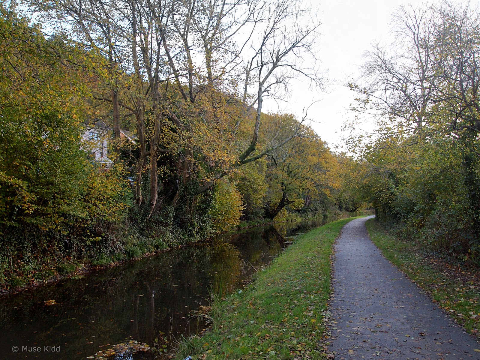
I first set off over the hill to Newbridge, down the lane to Abercarn, then under the motorway and through the sleepy village of Pontywaun. I begin my report across the road from the entrance to Cwmcarn Forest and at the northern terminus of the Crumlin Arm of the Monmouthshire & Brecon Canal.

I've cycled this route more times than I can count because it's often my way of going somewhere else. It's easy, mostly traffic-free, and it's lovely.
Note: I should point out too, that I often encounter many mountain bikers heading up this way toward Cwmcarn Forest. There you'll find some excellent mountain biking trails, as well as a full-service visitor centre with a cafe and toilets, and great camping facilities.

As I continue, you'll see that there are numerous bridges to duck under, small roads to cross, and a plethora of gates to squeeze past. It's all very safe if you take your time and be sure to ring your bell as you approach pedestrians, bridges, and dog-walkers.


Boats nolonger navigate this section of the canal, but it's wonderfully maintained for walkers and cyclists by the Canal & River Trust. Some parts are also co-managed with Sustrans Cymru as this is part of the National Cycle Network.

I spent two days documenting this route because we were experiencing an exceptionally lovely autumn and the foliage was looking especially stunning.

It was chilly when I first left, but the morning soon warmed up to 10°c (50°f). There were plenty of walkers out and I often had to wait several minutes to get the shot I wanted (i.e., without dogs or people wearing flashy jumpers!)


Ducks and Moorhens are two of the most common birds you'll see splashing about the canal. But if you look closely you can sometimes spot Kingfishers darting under the over-hanging branches. Herons can often be seen stalking the water's edge (image above).


Not really recognized because it is so short, the first part of the canal path from Pontywaun is actually NCN Route 465. However, after 1.27 mi. you reach a bridge where NCN Route 47 comes up from Crosskeys (lower right in the image above). This route then subsumes the canal path to become NCN Route 47 (which most folks presume is the entire canal path.)

Just past the bridge is our second notable landmark along the canal; Whysom's Wharf. Closed for the time being, there are rumours that the canal will one day be re-opened for boat traffic — which might allude to the wharf itself also re-opening.


Several properties back right up to the edge of the canal which have been lovingly landscaped — giving some sections a completely different look and feel (image above). But for the most part, the canal feels as if it's meadering though a thick forest.


The canal is actually cut into the hillside of a long ridge which runs south from Cwmcarn all the way to the city of Newport (roughly 7 mi.). The Crumlin Arm of the M&B Canal then merges with the eastern branch coming down from Brecon (image below).


Waiting for better light can be rewarding on its own. Listening to the birds, smelling the wild garlic mixed with the musty grass along the water's edge, hearing the rustle of something small scurrying about under the hedge; all this is mine when I simply pause to look around.


Up ahead, I can hear ducks quacking and splashing. It's a rucus, but I cannot see them yet.

Then as I turn the corner, they settle down and act as if nothing happened; paddling about, nonchalant, as if one said; "shhh, stop fooling around... here comes somebody!"


Gnomes!

Next I arrive at the historic 14 Locks. Whilst the Monmouthshire & Brecon Canal itself is over 200 years old, the museum and visitor centre here highlights the importance of the 14 Locks and how they serviced the canal. These closely linked locks raise the water level 160 ft. in just 800 yds. — making it one of the steepest rises for a major canal and one of the most significant canal features in the UK.

14 Locks is now both a destination, as well as a starting point for many walkers and cyclists. Along with ample parking, there is a small musuem and visitors centre, a cafe, gift shop, and public toilets. Picnic tables and benches are scattered about making this a perfect place to stop for a short break.
14 Locks to Newport
From 14 Locks the path decends dramatically. Whilst navigating past several ponds and gates, the path also gets quite narrow. It would be easy to just let go and let the bike fly, but I need to show caution as pedestrians and especially small children are often exploring the locks.


Many of the features found at 14 Locks are slowly being restored. Volunteers can be seen during the summer months working amoungst the thick brush, digging out the stone walls and pulling weeds from the canal beds. This section was once completely overgrown and unrecognizable, but the Canal & River Trust along with Newport County Burrough are working dilligently to restore these important Industrial Age works.

Here too, the canal and path switch sides. The canal will now be on my right for the remainder of the ride into Newport.

Then it's a very steep drop to the M4 motorway underpass. It's loud and dark underneath and you should ring your bell, because it's also a blind turn with little escape except for the drink (image below).


But then just as quickly, the path opens up again. The M4 motorway can be seen far off and below to my left (image below).

The traffic is surprisngly loud, even at this distance. (I really hate that too...)


The canal and path continue to weave together, slowly descending toward Newport and passing more locks and gates buried by years of abandonment.


Then once at the bottom, the canal and cycle path pull up along side (and slightly below) the very busy M4 motorway. Just under the hump bridge (image above) is where the two branches of the M&B Canal merge; the Crumlin Arm and the Brecon Arm.

Looking ahead, the sign pointing left is for NCN Route 49 which follows the canal north to Brecon. Whilst straight-on, NCN Route 47 continues into the city of Newport itself.


This bridge in particular is exceptionally low, making it worthwhile to walk under. On the other side, I found that it was also a pretty good spot for a self-indulgent bike photo.


From here it's just a short, but still quite attractive ride into the city proper where I'll then need to pay special attention to the route signs and unfortunately — a small bit of traffic.


One last hump and I'm there!
Newport
I haven't cycled extensively in Newport, but from what I've seen, the town does a pretty good job of providing designated cycle paths. They're not always "traffic-free", but most are well-marked and many have been improved over the past few years.

After leaving the canal, the first bit to navigate is a clever combination of overpass and underpass which avoids two major motorways; the A4042 and the A4051 as they converge in a "squirrels-nest" of on-ramps, exits, and flyovers. (See detail below: NCN route 47 comes in from the left.)

Coming out from under all that mess is bit difficult because the signing here is very poor. You need to look very closely because this is also where NCN Route 47 and NCN Route 88 cross each other. However, the postive news is that this is a very short section and if you do get confused, the two routes cross again shortly ahead.

The main difference between the two routes is that NCN Route 88 follows directly beside a very busy road, whilst NCN Route 47 heads out through a lovely little playing field and housing estate... and it's mostly traffic-free (see: below).


NCN Rotue 47 is a little longer, but it brings you out along the River Usk which affords a great view of the city and if you look closely... Newport Castle!

However, there is a small drawback... the path is closed as you come around the back of a group of allotments (image above). Previously, the route from here went through the castle itself leading directly to the riverfront. But unfortunatley, crime and anti-social behaviour lead to its closing.

Now I need to cycle a short distance through a housing estate to reach a series of overpasses. These clever elevated paths guide you directly to the Newport Railway Station. And this is in fact, a practical and useful alternative!

The bridge crosses back over the motorways and leads to a quiet lane behind the railway station. There was once an underpass here, but it too is now closed (image below). Time for another moody bike shot.


The good news is that Newport has redirected cyclists just a bit further up the road to a utilize a fancy new overpass.


It's bright and colourful and through a series of switchbacks it leads you directly to the mothership, I mean railway station.
Note: I say this in jest, because the thing looks like an alien spaceship (to me at least). And for someone not familiar with the town, you'd have no clue what this thing is, because there is not a single sign indicating that it is, in fact, a train station! Weird.

Now that we've seen the mothership, it's back across the overpasses where I will continue down NCN Route 47 as it travels along the Newport Riverfront.


There's also a couple of "sketchy" underpasses. These a very narrow and dark, so you should use caution and ring your bell, just to be polite (and safe!)


The path pops out briefly to show the castle. You can also see some stairs leading to where the cycle path once ran (image above).


As you reach the section of underpasses directly in front of the castle, there's an unusual model of the castle made from cast iron (image below). It's interesting, but somewhat of a poor substitute for being able to pass through the real thing.


Then a series of up and downs, turning left and right as you pass through the last couple of subways. And another bike photo which includes some good cycle path signage as well as a very nice mural/mosaic in the background.


The Newport Riverfront starts just under a massive red scuplture. The Wave by Peter Fink was errected in 1991 is part of the River Usk regeneration project.

Then there is the Newport City Footbridge. This massive pedestrian and cycling bridge joins the east and west banks of the River Usk. Erected in 2006 as part of the first major project to regenerate the city, the bridge also links to the Rodney Parade stadium. The image below shows the bridge during its construction, as well as how the Riverfront looked before its development. (I found this photo rather shocking to see the change.)

Attribution: Richard Scott-Smith at English Wikipedia

Looking back from the Newport City Footbridge you can see the city's oldest bridge; the Newport Town Bridge, which was opened in 1927 (image above).

Continuing down the riverfront, there are two more bridges; the George Street Bridge opened in 1964, is the first cable-stayed cantilever bridge built in the United Kingdom (image above) and further ahead is the City Bridge opened in 2004 (image below).


The remainder of the Riverfront ride is lovely. The path is wide and paved as it snakes past new homes and modern apartment buildings.


Just past the City Bridge is a small park and WWI monumment both of which face the most famous bridge along this route; The Newport Transporter Bridge (image below).

I have to admit to a lapse in judgement, but for some reason I stopped taking photographs here. The images of the bridge below are from a ride made in 2017.


Meanwhile, there is also a missing segment covering the next six miles through Newport Docks, Duffryn, Tredegar Parc, and back up to the Monmouthshire & Brecon Canal. That will be for another day, another ride.

I've mapped out this missing part of my ride in the image above and hopefully, this will motivate me to document the remainder of this section in the near future.
High Cross to Sirhowy Parc
I begin my documentary again back on the Crumlin Arm of the Monmouthshire & Brecon Canal just above High Cross and heading north. It's late in the afternoon and though the light has changed dramatically, the colours are still vivid and lush.


We've had an exceptionally rainy summer which has enhanced the growth of algea in the canals giving them an eerie green glow.


A couple of miles ahead and just before Crosskeys is one of my favourite sections of the canal. I've photographed this part numerous times and it always looks cool. Today was an exceptional day for the colours... and it looks primeval.

Note: I left out another short section, heading from the canal path up through Wanfawr Parc to Sirhowy Parc.
Sirhowy Valley Country Park
Sirhowy Valley Country Park and the Southern Sirhowy Valley has a rich history with tramroads and railways. Of course there were a few small colleries in the area, but because of the valley's narrow width, this part of the valley was utilized mostly for the transport of coal. The first plate-rail tramroad was established in 1805 and was operated by horse traction. This was later replaced by locomotive engines in 1863 and even a passenger service ran through here at one time.
The walking and cycle path we have here today was developed by Sustrans and the National Cycle Network between 2009 & 2011 and stands as a primary example of an "ideal" design for shared-use paths. The path is also a part of NCN Route 47 and this particular section runs for over four traffic-free miles between Wattsville in the south to Gelligroes in the north.
The walking and cycle path we have here today was developed by Sustrans and the National Cycle Network between 2009 & 2011 and stands as a primary example of an "ideal" design for shared-use paths. The path is also a part of NCN Route 47 and this particular section runs for over four traffic-free miles between Wattsville in the south to Gelligroes in the north.

Wales is very fortunate to have this unusual park and we're personally fortunate to live so close to it. I cycle through here on my way home very often. I made a short report back in 2022 starting north of here in Gelligoes and heading south to the entrance shown above. You can see the images and read that report here: Sirhowy Country Parc.

The park once had a visitor centre and ranger station, but the Full Moon House is mostly empty now (image above). The toilets are open at certain times, but the flyers on display in the bulletin board are 4 - 5 years out of date.

After the main entrance and gates, there is a small service road that leads to a second car park where the traffic-free section begins.


There are picnic tables and benches scattered throughout the length of the park making it convenient for families and cyclists of all ages and skill levels.

And the route looks like this for four continuous traffic-free miles!

I can't say much more about it. Sirhowy Valley Country Park is wonderful.
SUMMARY
14 Locks, Newport & Sirhowy Parc
By now you should have a pretty clear idea of my enthusiasm for these routes and how amazing it is that they can be combined and/or connected. Sustrans and the National Cycle Network have created a unique treasure that deserves more recognition.
Here is the Valleys of South East Wales we are especially fortunate because of the high number of disused railways which have been converted into fantastic walking and cycling paths. Thanks Sustrans! You ROCK!
Here is the Valleys of South East Wales we are especially fortunate because of the high number of disused railways which have been converted into fantastic walking and cycling paths. Thanks Sustrans! You ROCK!
I had a great time wandering along these two routes. The weather was exceptionally nice and it felt good to relax and just take photos at my leisure (I still don't know what happened in Newport?)
But as routes go, these two; the Crumlin Arm of the Monmouthshire & Brecon Canal and Sirhowy Country Park rank amoungst my two most often cycled, as well as two of my favourites. Now from here, it's up to you to go see them for yourself.
I hope you enjoyed my report and thanks for reading!
Seeya down the road... Cheers! - cm
