Between Raglan and Newport, lying within the Vale of Usk; is a wide variety of beautiful and safe country lanes to ride your bicycle. In this report I will highlight a large circular route which covers many of my favourite sections.

Overview - Raglan Ramble [ explore ]
Date: March 19, 2021
Distance: 78.5 miles / 126.33 kilometres
Elevation: +3,876 ft / -3,875 ft
Duration: 7 hours, 35 mins.
Distance: 78.5 miles / 126.33 kilometres
Elevation: +3,876 ft / -3,875 ft
Duration: 7 hours, 35 mins.
There are sections of this route I have cycled numerous times. Then there other parts which I've only just discovered. Today's ride includes a "prelude" as part of my research for another project. However, the main focus of this report will be on the route from Pontypool to Newport (Parts Two, Three, and Four).
This is a work in progress and appears as a sort of "sketch"; which includes an assortment of ideas, many of which will be edited down for a more user-friendly final version.
As I was exploring, I encountered several road closures, forced detours, and once I got completely turned around; therefore, I will need to revisit some areas. Also, be forewarned; this is a long read!
Note: The map above includes my entire day of cycling from Oakdale through Raglan and then back home.
PRELUDE | Getting to the Start
Crumlin to Pontymoile Boat Basin - Traffic-free from Crumlin to Llanhilleth, then on a quiet road for 7.8 miles following NCN Route 466.
PART TWO | Monmouth & Brecon Canal | 5.5 miles
Pontymoile Boat Basin to Goytre - 5 miles traffic-free along the Monmouthshire & Brecon Canal (NCN Route 49). Exit bridge 72, then .5 mile to Goytre along quiet lane.
PART THREE | Raglan Ramble | 11.5 miles
Goytre to Raglan - This section is entirely on the road, yet the route follows quiet lanes that snake through lovely countryside for 11.5 miles to Raglan.
PART FOUR | Vale of Usk | 19.2 miles
Raglan to Newport - This section follows mostly quiet lanes for 15 miles from Raglan to Caerleon where it then joins traffic-free NCN Route 88 for 3 miles to Newport. In Newport, the route joins NCN Route 47 for one mile to the junction of NCN Route 49.
Relevant links, links to individual NCN Route maps, an overall Map & Cue Sheet for download, as well as local train and weather information located at the end of this report.
Crumlin to Pontymoile Boat Basin - Traffic-free from Crumlin to Llanhilleth, then on a quiet road for 7.8 miles following NCN Route 466.
PART TWO | Monmouth & Brecon Canal | 5.5 miles
Pontymoile Boat Basin to Goytre - 5 miles traffic-free along the Monmouthshire & Brecon Canal (NCN Route 49). Exit bridge 72, then .5 mile to Goytre along quiet lane.
PART THREE | Raglan Ramble | 11.5 miles
Goytre to Raglan - This section is entirely on the road, yet the route follows quiet lanes that snake through lovely countryside for 11.5 miles to Raglan.
PART FOUR | Vale of Usk | 19.2 miles
Raglan to Newport - This section follows mostly quiet lanes for 15 miles from Raglan to Caerleon where it then joins traffic-free NCN Route 88 for 3 miles to Newport. In Newport, the route joins NCN Route 47 for one mile to the junction of NCN Route 49.
Additionally, this route includes the following special sub-sections:
SUMMARY | A Compilation of Details
- Lord Raglan's Bugatti - A 3.5 mile bypass between Chepstow Rd. and Monmouth Rd.
- Mouseman's Gate - An alternate 2.2 mile route between Monmouth Rd. and NCN Route 42 bypassing Usk.
Relevant links, links to individual NCN Route maps, an overall Map & Cue Sheet for download, as well as local train and weather information located at the end of this report.
PRELUDE
| NCN | 466 |  |
Getting to the Start |
Distance: 7.8 miles / 12.55 kilometres
Elevation: +700 ft / -565 ft
Elevation: +700 ft / -565 ft
This part of my ride to Pontypool will be not be included in my final "Raglan Ramble Route". This prelude is simply for documentation that I'll use on another project.
The forecast was for light rain all morning, but by the afternoon skies were to clear. The temperature was chilly at 4°c (49°f), but some days ya just gotta ride despite what the weatherman says.
The forecast was for light rain all morning, but by the afternoon skies were to clear. The temperature was chilly at 4°c (49°f), but some days ya just gotta ride despite what the weatherman says.

Running between Crumlin and Llanhilleth is a short but important connector which is not indicated on many maps. However, the route we need to follow is labled NCN Route 465 and as we can see (above) the disused road is clearly here and best of all, it is closed to traffic.

The connector runs .75 mile to Llanhilleth where you then have two options: continue north on NCN Route 465 toward Abertillary (now marked on most maps...) or turn onto NCN Route 466 and head east toward Swffyrd and Pontypool.

Today, I'm heading east on NCN Route 466 toward Swffyrd and Pontypool which begins on a fairly new cycle path (shown on the left in the photo above). It's a steady climb, but it's not too difficult and the pavement is excellent. There is a bit of a challenge just as you reach the top where you then have a short "push" into the village of Swffyrd.


The route is mostly straight for the first .5 mile, but then as it gently veers to the left the incline begins to increase for the last .25 mile. The traffic-free path ends as you enter the road at a housing estate and there the route becomes VERY steep.

Looking up the short "push" (above) and then back down from the top (below). You can now see across Ebbw Valley to the far hillside village of Treowen. I came over that far ridge from Oakdale, descended into the valley, crossed the Ebbw River, and have now climbed to the top of this side of the valley. My distance so far (zig-zagging) is just over seven miles.


After the short "push", it's an easy ride through the villages of Swffryd and Hafodyrynys to where the route again becomes traffic-free as it parallels the very busy A472 heading east toward Pontypool.


The traffic-free section ends after a mile and crosses the A472 where it then merges onto the Old Crumlin Road for the remainder of the ride to Pontypool. This crossing (shown above) can be a very difficult and dangerous crossing. Show caution!

Fortunately, once on the other side, there is hardly any traffic on the old road and it just rolls along overlooking the main road for three scenic miles. It's wonderful.
There are many online applications from which to choose when mapping a cycle route. I have chosen Ride with GPS as my main resource for a number of reasons. Primarily, the application is straight-forward and simple to use, and then secondly; sharing (or embedding) my routes within my blog couldn't be easier.
In the map above (fig. 1), I have taken a screen shot of a highlighted section from the overall route. This useful to see where the section fits within the overall route by providing a sense of scale, as well as the indicating the length and elevation details.
In the second screenshot (fig. 2), I have actually created a specific route (in RwGPS) for the sub-section of the overall route. This process is more time consuming, but it does offer some advantages. One; you can see the details of the sub-section much more clearly and two, I can provide not only the image as shown above, but I can also have a direct link to the route in RwGPS for even more detail. See: NCN Route 466; Crumlin - Pontymoile
Making the process even more complicated, I have found a new cycle mapping website; CyclOSM, which will display the section of cycle route I want to embed by the specific coordinates. It is simple to create and view, but involves a totally different web application and I am unsure of the ability to download .gpx files.
 |
| fig.1 |
 |
| fig.2 |
| fig.3 |
It should be emphasised NCN Route 466 is a significant connector for this part of the Southeast Valleys. I will be using this route with several of my planned routes because there are very vew ways in which to cross the valleys west to east. The next crossing is 10 miles further north at Brynmawr at the Heads of the Valley or 12 miles south; all the way to the bottom of the Valleys at Newport.

Coming into Pontypool can be awkward with several roundabouts to navigate, a very busy Tescos, and all that entails negotiating a bustling town centre. But it's only .5 mile down the High Street to Pontypool Park... which is lovely and calm and quiet. (Photos needed...)
Note: NCN Route 492 passes over the road at the roundabout by Tescos in Pontypool. There are stairs to the right of the roundabout leading up to the traffic-free path, but it is not clearly marked and it is easy to miss.


From Pontypool Park it's just a short jaunt down a back lane to Pontymoile Boat Basin and the "official start" of my ride.

The entrance to Pontymoile Boat Basin isn't looking that grand today, but the day itself is to blame (another place for better photos...). This is a popular starting point for walkers and cyclists alike and can be quite busy. There is a cafe (above right), toilets, plenty of parking, and it is quite near the local train station.
Note: Exciting news! This area is under consideration for a redevelopment project: Activities centre and cafe plan for Pontymoile canal basin.


It's time for me to take a break before I begin again. Get yourself a cuppa, take a moment to read my little sidebar below and we'll get going again.
Here in the UK we are very fortunate to have The National Cycle Network, a vast network consisting of nearly 13,000 miles of signed walking and cycle paths. The routes are managed by Sustrans, who along with Ordnance Survey publish an array of printed paper maps as well as post a multitude of interactive online maps.
In Wales alone, there are over 2,000 miles of designated cycle routes (800 miles of which are traffic-free). For a country so small (roughly the size of the state of Massachussetts in the USA or half the size of Switzerland), this cycle network weaves across the entire country. This is the core of my route planning.
Looking at the map below, it is easy to see how the indivdual routes connect. (The yellow lines are traffic-free, while the blue lines are on-road or dual-use pavements.) I plan to include the details of train stations, nearby car parks, and essential services for each of my combined routes. You can view an early prototype here: Clydach Gorge.
A Brief Background: The Southeast Valleys were once dominated by coal mines. Hundreds of these mines lined the valleys and not-surprisingly, along with those mines also ran trains to support them. Now the coal mines are gone as well as most of the trains, but what was left behind is a vast network of disused rail lines. This is what Sustrans has developed and continues to develop to this day; re-purposing disused rail lines and creating safe cycleways.
 |
| The National Cycle Network in Wales |
Looking at the map below, it is easy to see how the indivdual routes connect. (The yellow lines are traffic-free, while the blue lines are on-road or dual-use pavements.) I plan to include the details of train stations, nearby car parks, and essential services for each of my combined routes. You can view an early prototype here: Clydach Gorge.
 |
| The National Cycle Network in Southeast Valleys of Wales |
Naturally, you might ask if there is already a National Cycle Network, why would I feel the need to create my own cycle routes? Well, because we have such a dense concentration of shorter NCN Routes, my plan is to offer suggestions on how these existing routes may be combined to form longer (and often circular) rides for the adventure cyclist.
PART TWO
| NCN | 49 | |
Pontymoile Boat Basin - Goytre |
Distance: 5.5 miles / 8.85 kilometres
Elevation: +255 ft / -312 ft
Elevation: +255 ft / -312 ft
The Monmouth & Brecon Canal from Pontymoile Boat Basin is a wonderful section. However, we'll be riding only a short distance of the much longer NCN Route 49 which runs 35 miles between Brecon in the north all the way to Newport in the south.
Note: For some ubknown reason, Sustrans only lists the route running to Abergavenny, but having cycled the full-length, I can attest to the route being there!
Watch for walkers and their dogs, especially at bridges! Remember pedestrians have the right of way. (Use your bell to let folks know you're coming through.) Take your time. Stop often. Take pictures. You've got five miles of lovely scenic Wales. Enjoy!
| ▲ Back to |
| ROUTE COLOUR KEY: | Traffic-free | Quiet Road | Shared Use | Steep Hill |
Some places may have pools of standing water, but the path mostly consists of finely packed gravel — yet varies in width as it snakes and weaves along the sides of the valley.

I've probably photographed this section of the Monmouth & Brecon Canal more than any other. It's hard to resist and frankly, it's hard to not a take a great photo.


You'll pass under 20 bridges between Pontymoile and Bridge 72 (our exit point). They come in all shapes and sizes. Some are quite easy to cycle under whilst others are rather low so it's suggested that you dismount and walk.
I also suggest stopping at some point, getting off your bike and walking around. Sometimes the views are quite surprising.
I also suggest stopping at some point, getting off your bike and walking around. Sometimes the views are quite surprising.


Around every bend there seems to be yet another amazing view. The combination of calm dark water lined by trees, behind which lay wide green pastures against the rolling hillside is simply gorgeous.


There are some locations where I tell myself to not take any more photos because I have so many, but then there are some places where I simply cannot resist and I take a photo everytime I cycle through.

There are many lovely homes along the canal, many of which have taken a rather gentrified approach to their presentation. I have to admit that I prefer the more bohemian esthetic.


And of course, boats add to the charm and character of the canal. It's early in the season and it's been rather cold too, but I expect to see more of these as the year progresses.
A man lives year-round in the narrow boat shown above; as you can tell by how well his floating home is out-fitted. I love his little cart for carrying groceries and firewood. Plus he's got a kayak... how cool is that?!? Take note tiny home fanatics.
A man lives year-round in the narrow boat shown above; as you can tell by how well his floating home is out-fitted. I love his little cart for carrying groceries and firewood. Plus he's got a kayak... how cool is that?!? Take note tiny home fanatics.

All good things come to an end and our ride along the Monmouth & Brecon Canal ends just after Bridge 72. From here it's just a quick half mile glide down to Goytre.


Crossing the A4042 can be tricky because it is often very busy, but once on the other side the route becomes quiet again. There are shops, a post office, a pub (above on the right), gas station, and even public toilets.

This a a good place to take a break, get of your bike and walk around a bit. There will not be another source for food or drinks for the next 12 miles.
PART THREE
ON ROAD |
Raglan Ramble |
Distance: 11.5 miles / 18.50 kilometres
Elevation: +470 ft / -628 ft
Elevation: +470 ft / -628 ft
This section is entirely on the road, yet the route follows quiet lanes that snake through lovely countryside all the way to the town of Raglan. The road surface is entirely paved, but there can be loose gravel and standing water in places.
| ▲ Back to |
| ROUTE COLOUR KEY: | Traffic-free | Shared Use | Quiet Road | Steep Hill |
The first couple of miles out of Goytre rolls along gently as it parallels the train line heading north to Abergavenny. The route then arcs along a high ridge cutting across the northern half of the Vale of Usk.


The route takes us into the country now where traffic is practically non-existant. Farmers are plodding about in their tractors working the fields. Far off to our left the Skirrid stands alone in the sun.


A little further down the road The Sugar Loaf can be seen far off on the horizon with it's peak in the clouds (above). Then the road turns and descends steeply into the valley. The road is fairly narrow but the turns are wide and sweeping.


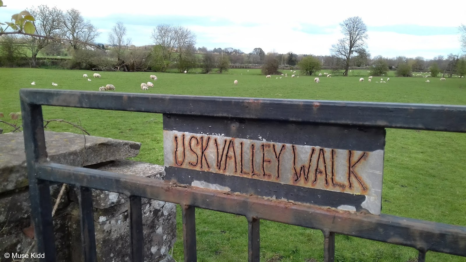
At the bottom of the hill, our ride turns left onto the (moderately) busy B4598 for just a short hop across the Usk River (see sidebar below) followed by a right turn back onto a quiet lane which runs along the river.
I went to look for some information on the Pant-y-Goitre Bridge and was quite surprised to find that there are so few bridges that cross the River Usk (12!). Not only is the small amount surprising, but also that I've probably photographed most of them at some point. This has the makings of a great little cycling/photography project - to cycle and document the Bridges over the River Usk.
 History: John Upton designed and built the bridge in 1821 as part of improvements to the turnpike road between Abergavenny and Usk. Upton also designed and built the nearby Llanellen Bridge.
Description: The bridge has three spans with 10 spandrel circular voids, all constructed of ashlar stone. The two outermost voids also provide access between the fields on either side for livestock, as well as the occasional walkers as this is part of the Usk Valley Walk. The bridge is a Grade II* listed structure.
 |
| The Pant-y-Goitre Bridge near the village of Llanfair Kilgeddin. |
Description: The bridge has three spans with 10 spandrel circular voids, all constructed of ashlar stone. The two outermost voids also provide access between the fields on either side for livestock, as well as the occasional walkers as this is part of the Usk Valley Walk. The bridge is a Grade II* listed structure.
At the next junction, we turn right again onto Clytha/Abergavenny Road for.25 mile where we then turn left toward Llanarth and Llanarth Court. (We just went left, right, right, and left again... all within a mile.)
Note: you will see signs for NCN Route 42, but we are on it for just a short while as it soon turns off while we will continue on toward Llanarth.

Before reaching Llanarth proper, our route turns right toward the lovely little village of Great Oak. We glide throught the community and circle the grounds of the massive Llanarth Court.


Far off across the expansive private grounds, sits Llanarth Court (right of center, partially obscured by trees). Once the 16th century private estate of Ivor Herbert, 1st Baron of Treowen, it's now a privately run institution for low to medium secure criminals diagnosed with mental health issues.
Behind that looms the always impressive; Skirrid
Behind that looms the always impressive; Skirrid


As you leave the village, the countryside opens up yet again providing more lovely scenery and some excellent cycling that just rolls along for the next few miles.


It's especially nice this year because they've cut the hedges. Last year the hedges were perhaps twice as high and in places it was like cycling through a maze.

Since leaving Goytre I have only seen one vehicle on the road; a small delivery van. It's incredible. I feel as if I have the entire countryside to myself.

I cycled past this house and thought; "I should have photographed that place". So, I turned around and went back. I just love it.

Then after the next short rise (approximately 10 miles from Goytre) the road turns sharply to the right and offers a surprising little climb which is deceptively steep. Thankfully it's short, but when you reach the top the views are spectacular!


Can you see it? It's there just over the hill. Look closely and you should be able to make out the tops of Raglan Castle. Let's hop this fence and get a closer look, shall we?

This is the perfect place and subject to test the quality of the zoom feature on my camera, eh? (The smell of the rape seed is simply intoxicating, btw.)


Not too shabby. They get somewhat "lossy", but overall, I'm pleased. It's just tremdously cool to see the castle from here.

And were I to ever teach a class on landscape photography, here's a lesson I would try to convey; "always turn around and look behind you. Look to see from where you came."
The photo below is a prime example. I just turned around to walk back to my bike and voila! A lovely little scene by a pond.
The photo below is a prime example. I just turned around to walk back to my bike and voila! A lovely little scene by a pond.

Then it's a short and fast ride down the hill to Clytha Road again. Turn left up to the very busy roundabout. Show extreme caution as you crossover the A40 into Raglan.

Once you've made it past the roundabout, coming into Raglan is lovely. It can be a little busy along the narrow High Street, pedestrians are the main concern, so just take your time. It's worth going slowly to take in the details.


It's a very small village, but there are a few shops, a couple of pubs, and a garage. The town square is a great little spot to stop for lunch where you can "people watch" all day.
Note: Additionally, this is the junction with NCN Route 423, which runs between Cwmbran and Monmouth.

It was a fine Spring day and the daffodils were in full bloom.
During the Autumn of 2020 I began thinking about this town and all the times that I've visited here. The town of Raglan dates back to the early 14th century and is well known for the castle which stands just outside of town.
The Kingfishers introduced me to this area back in 2012 and I've grown to think of it as a central location for cycling adventures. We would cycle to Usk just about every Tuesday. If we wanted to go a little further, we'd often end up here. On the long summer days, we'd sometimes continue on to Monmouth.
So the lanes between Usk and Monmouth were our stomping ground and Raglan became the unofficial "middle-child".
This is how I've come to know the area and now I feel compelled to create a route which highlights many of the lanes and the countryside I've come to love.
 |
| The square in Raglan |
 |
| The Beaufort Hotel |
 |
| St. Cadoc's Church |
 |
| Looking north from the square. |

More daffodils line the road as we head out of town.
PART FOUR
| ON ROAD |  |
Vale of Usk |
Distance: 19.2 miles
Elevation: +1,004 ft / -1,096 ft
Elevation: +1,004 ft / -1,096 ft
Our last section follows mostly quiet lanes though the country for the next 19 miles. We'll not pass through any villages with shops or toilets until we reach Caerleon where our ride then joins NCN Route 88 for the remaining three traffic-free miles into Newport.
| ▲ Back to |
| ROUTE COLOUR KEY: | Traffic-free | Shared Use | Quiet Road | Steep Hill |
We head out of Raglan on Chepstow Road. The speed limit goes up to 50 mph, but the road is wide and mostly straight. Cyclists are commonly found pedalling along here and drivers are generally considerate. However, we won't be on this section very long; after one mile we exit off to the right and head toward the quaint village of Llandenny.

You can slow down now and relax again. We've got just under four miles of quiet, undulating lanes. I call this bypass route Lord Raglan's Bugatti. (A very special thanks goes out to Eric Ivins for showing me this section! Cheers buddy, I love it.)


Pause for architecture; there are some lovely farm houses to be seen.


Coming into the village of Llandenny, the 12th century Church of St John the Apostle and Evangelist sits on a slight rise to our right.


The village itself is incredibly cute and sleepy. If you see someone, they'll be sure to smile and wave hello. I get the feeling that they enjoy seeing cyclists doddle through their village. (The Raglan Arms looks mighty tempting too!)


Soon enough, you will be out of the village and heading back into the country side. There is a short little climb past what I can only descibe as a "failed orchard". At the top of the hill we turn left at the junction toward Usk.


Several years ago, the Kingfishers took a detour off our usual route to Raglan. Before reaching Monmouth Road, we turned left onto a poorly paved road heading into the trees then up and over the A449 dual-carriageway.
It was a rather uninsipred looking route, but as we pedaled along, John told us a story of one of his many chance encounters with FitzRoy Somerset, the fifth Lord Raglan.
Not knowing much about the man ourselves, we just followed John along nodding our heads and listening curiously to see where his story would lead. Then he stopped at a rather unassuming fork in the road...
Cefn Tilla Court has its roots in the 17th century, but was later purchased and rebuilt as a memorial to Field Marshal FitzRoy James Henry Somerset, the 1st Baron Raglan. Lord Raglan was commander of the British troops sent to the Crimea in 1854 and most noted for the infamous Charge of the Light Brigade.
Okay. So there's that, but before I digress into the depths of all that history, we should move forward 150 years to the 20th century because this is the point of my story. (For a brief overview, this article is exceptional: How a family feud threatened the legacy of a Crimean War leader.)
As it turned out FitzRoy John Somerset, 5th Baron Raglan (of whom John spoke of...) was something of an eccentric. Unmarried, childless, and wealthy, FitzRoy was free to spend his leasure time as he pleased. And as I later came to discover... He had a particular fondness for vintage cars.
Lord Raglan could be seen driving his 1933 Type 51 Bugatti along these roads and I cannot but think of him and that car as we cycle along. It is a fabulous bypass off of the main roads with a charming touch of history. Therefore, I've named this 3.5 mile section Lord Raglan's Bugatti out of respect and to remember the man (FitzRoy John Somerset, 5th Baron Raglan; 6 November 1927 – 24 January 2010).
You can read about the Baron Raglan title or about sale of his cars after the 5th Baron's death in 2010 here: "Lord's Bugatti and Cabriolet sell for £1.3m in Paris".
It was a rather uninsipred looking route, but as we pedaled along, John told us a story of one of his many chance encounters with FitzRoy Somerset, the fifth Lord Raglan.
Not knowing much about the man ourselves, we just followed John along nodding our heads and listening curiously to see where his story would lead. Then he stopped at a rather unassuming fork in the road...
 |
| The Cefn Tilla sign is a recent addition... |
Okay. So there's that, but before I digress into the depths of all that history, we should move forward 150 years to the 20th century because this is the point of my story. (For a brief overview, this article is exceptional: How a family feud threatened the legacy of a Crimean War leader.)
 |
| Cefntilla Court |
 |
| The man in 1969... |
 |
| The man and his car... |
 |
| "Lord Raglan's Bugatti" — the route. |

I find it quite easy to envision the Baron in his little red sports car zipping along these lanes?


Many may say that this is just a tree... but I find it quite stately and lovely.


Looking out over Lord Raglan's Estate (above)... and across the road (below).

Then the road turns abrutly, passes over the A449, and un-characteristically becomes well-paved and much wider. This is how they build roads now. It is completely uninspired and dull. What we've previously cycled down is sadly becoming a dying breed.


At the junction of Monmouth Road our little ride along Lord Raglan's Bugatti ends.

It's impossible to miss the noise, but if you look up you'll see a murder of crows! (Adjusting the exposure on my little camera whilst pointing directly at the sky is rather difficult, but I gave it a couple of tries.)

We turn right onto Chepstow Road and follow it for .5 mile, then turn left onto a very small road after passing the Llangeview Lodge. Chepstow Road is a 50 mph zone and can be quite busy; however, this part is perfectly straight and it is popular with cyclists. (Photos needed!)
Note: If you continue going straight on Monmouth Road it will lead you into the town of Usk in approximately two miles. It is a fairly large town with a busy high street of shops, hotels, pubs, etc. It is also the junction of NCN Routes 42 and 423.

If you are unfamiliar with Wales, you might find it odd to see that many of the country lanes don't have names. This is a prime example. It's just a small lane leading toward Allt-y-Bella (a private 14th century farmhouse now converted into a posh B&B.)
We however, are not here for that... we are in search of the lovely small lanes which weave through the countryside. This is what cycling is all about.
We however, are not here for that... we are in search of the lovely small lanes which weave through the countryside. This is what cycling is all about.


And to be honest, as much as I appreciate restored architecture, I find myself drawn to old barns and disused buildings, abandoned sheds, even stone walls buried deep in the underbrush captivate my imagination. What happened here? What stories do they hold?
I took the photo below last year when I first discovered this lane. The image speaks to me on a level I find hard to describe and it is one of my favourites.
I took the photo below last year when I first discovered this lane. The image speaks to me on a level I find hard to describe and it is one of my favourites.

Across the road from the barn is a lovely little church maintained by: "Friends of the the Friendless Churches". Check out their website... it's quite interesting.


We head on, winding down the lane with new vistas opening before us at every turn.

Just after we cross over the A449 (again!), the road climbs slightly and looking over the hedge to our right, the River Usk slowly winds it way from the town of its namesake.
Note: The road which can be seen following the river is NCN Route 42 which we'll be joining in just a few minutes.


But for now it's time to take a short break for we've been provided a lovely location high on a ridge overlooking the Vale of Usk.
Off to our left is a very old farm (the details of which I've yet to uncover). But, peeking around the massive cedar tree by the front gate, I would guess the house is 14th/15th century? I am curious to learn more.
Off to our left is a very old farm (the details of which I've yet to uncover). But, peeking around the massive cedar tree by the front gate, I would guess the house is 14th/15th century? I am curious to learn more.


Back on the road, this section ends a short distance ahead at the junction just across from the old church in Llanllowell. This is NCN Route 42 which I mentioned previously.
Unlike the church we saw back at Llangeview, this one is a sad affair and appears to have no friends. However, there is something special about this church as pointed out to me again by John Wilson.
Robert (Mouseman) Thompson was a furniture maker and designer whose work became popular during the 1920's Arts & Crafts movement.
You may be wondering what does this have to do with cycling and to be perfectly frank; nothing. But it does have to do with why we're cycling and what we so often pass by as we speed along in our cars - or on our bikes for that matter.
Not so long ago, this church was active; people could be seen attending services and walking about the cemetary. I remember passing ladies as they planted flowers along the road, but in less than ten years, it now seems to be all but forgotten.
For me, cycling is about appreciating the places you cycle through. Taking the time to stop now and again to look around, to look at the details.
If you look closely, you can see that the gates here are special indeed for they were made by Robert (Mouseman) Thompson during the 1950's.
So much of our lives focus on destinations and goals - distances are measured, recorded, and ranked as how fast they were achieved. I've outlined this route to bypass the busy roads leading into and out of Usk for a reason... this route offers a slower pace to reflect on why we're cycling.
Take your time. Look at the world around you. Just like this little mouse on this old forgotten gate; one day all this will be gone.
You can read about the famous furniture maker Robert (Mouseman) Thompson and even purchase some of his furniture here: The Mouseman Visitor Centre.
 |
| You can now purchase Llanllowell Church. |
 |
| © Fair Use; Photograph of Robert Thompson (designer) (1876–1955); Wikipedia |
Not so long ago, this church was active; people could be seen attending services and walking about the cemetary. I remember passing ladies as they planted flowers along the road, but in less than ten years, it now seems to be all but forgotten.
 |
| How many folks have walked through this gate without notice? |
 |
| There is the trademark of a famous British furniture designer... |
 |
| "Mouseman's Gate" — the route. |
Take your time. Look at the world around you. Just like this little mouse on this old forgotten gate; one day all this will be gone.
You can read about the famous furniture maker Robert (Mouseman) Thompson and even purchase some of his furniture here: The Mouseman Visitor Centre.
We now turn left onto NCN Route 42 heading south toward Llantrisant and we don't have to go far before we encounter another roadside detail.

This old waymarker was buried deep beneath heavy brush, until a tractor came along cutting back the verge and literally stumbled across it. The marker has since been repaired along with having a post installed to let future mowers (and us!) be aware of it's location.

It's interesting because the marker shows how this was an important route between Usk and Portskewett. Of course, that village has a fascinating history too - as it was the main crossing of the Severn River for over 150 years (before there were any bridges!). But I digress... let's get back on the road!


I've been told that this part of our route was once the Roman road that ran between Caerleon and Usk. But for whatever it's worth, this particular wooded section is called "Gypsies Tump".

Exiting from the wooded area, the lane then levels out for a couple of miles and offers some lovely views overlooking the fields lining the River Usk.


And for the most part the road continues undualting above the river for the remainder of the ride into Caerleon. It's a peaceful ride with little traffic and it's quite popular with cyclists who often use this route for zipping between Usk and Newport.


Before reaching the city of Newport however, we're treated to the lovely village of Caerleon. We have to cross the river Usk once again to reach the village proper, and it's worthwhile to plan for a short stop.


The Hanbury Arms (shown above) is a great place to stop for a bite to eat. Parts of the building date back to the 13th century whilst the views over looking the river are wonderful. You can sit outside on a late afternoon and reflect on the days adventure with a pint.

Once on the other side of the river, we enter onto the traffic-free NCN Route 88, which will lead us for approximately 4 miles into Newport City centre.

It's worthwhile to do a little research beforehand and plan where you wish to stop. Caerleon was once an important Roman city and is a fascinating place to explore. The National Roman Legion Museum is quite interesting and the roman amphitheatre (shown above) is a great place for a picnic.

The cyclepath heading out of Caerleon (NCN Route 88) provides quite an unusual raised boardwalk following the river.

As the late afternoon sun begins to creep toward the horizon our long day is nearing its end as we make our way into Newport.


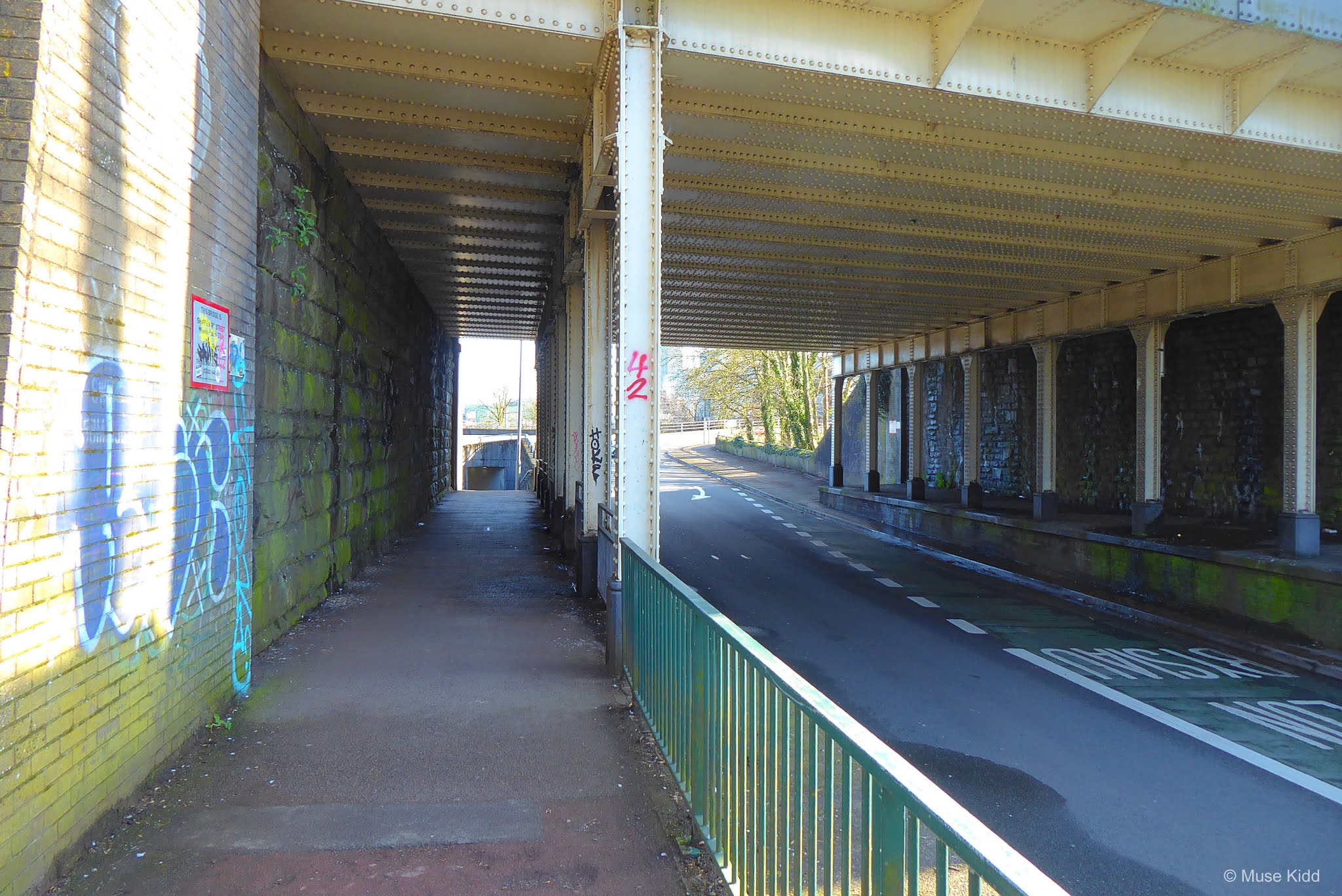
Passing under the very busy (and loud!) M4 we are rewarded with some interesting artwork.


I always stop to take photos of grafitti that I like. Once this area was dominated by the homeless and was extremely rank to cycle through. Now, it is taking on the feel of an urban art gallery. Graffiti generally has a very short lifespan, so I imagine all this will be painted over/repainted in the near future, but I'm glad I stopped to document for posterity.


There are many turns and road crossings as we near the town centre and train station. The main consideration is that there are shared-use paths all the way and as you can see below, some sections are very accessable via raised walkways.


It seems very congested with the roads heading in every direction, but it's really quite small and the train station sits just beyond Newport Castle.

So this is where my photography ends. I'll develop the details heading to the train station as I work up the route heading up to Pontymoile Boat Basin (Part One).
Summary: Raglan Ramble [ explore ]
I developed the overall route and images used in this project over the course of three seperate rides which eventually spread over two months. I took an enormous of photos (as you have seen by now!) and I've got a good start for the final project.
Note: The map above includes my entire day of cycling from Oakdale and back. When my final route is completed it will be much shorter with starting and ending points at Newport and Pontypool.
My ride included several detours, so I think I'll need one more trip to explore some of the closed sections before I can complete these three parts.
I also need to gather train station(s) details, relevant links, and local weather details - as I've included in my previous route plans.
Keep an eye out for my next report; Raglan Ramble - Part 1: Newport to Pontypool. From there I'll edit and stitch the two reports into one cohesive route.
Hopefully, the weather will clear soon so I can get back on the road and finish this little project.
I hope you enjoyed this little write-up and as always, thanks for spending your time with me & Bike Wales.
Cheers! - muse kidd
| Ride Name: | Raglan Ramble [ex] |
| Start Date: | Mon. Mar. 19, 2021 |
| Starts in: | Oakdale, Wales, GB |
| Departed: | 8:20 am |
| Distance: | 78.5 mi / 126.33 km |
| Elevation: | + 3876 / - 3875 ft |
| Max Grade: | 12.7% |
| Duration: | 13:15:23 |
| Move Time: | 07:35:16 |
| Stop Time: | 05:40:07 |
| Max. Speed: | 33.4 mph |
| Avg. Speed: | 10.3 mph |
| Weather: | sun, clouds, rain |
| Temp: | 15°c / 59°f |