Back in 2015 I had my first glimpse of this mystical place whilst on a group ride to Swansea — it just so happened to be an all-night ride and under a full moon. I have wanted to return for a proper visit ever since.
UPDATED!


- 2018 -
Overview: Ogmore-by-the-Sea Odyssey
Date: May 18, 2018
Distance: 109.7 miles / 176.22 kilometres
Elevation: + 5940 / - 5940 ft
Duration: 14 hours, 13 mins.
Distance: 109.7 miles / 176.22 kilometres
Elevation: + 5940 / - 5940 ft
Duration: 14 hours, 13 mins.
Iwas very excited about this ride, but I had no idea it would become as epic as it turned out. The weather was warm and sunny. Traffic was non-existant and I rolled along in perfect solitude for most of the day.
As I recount the day, I was quite fortunate and it feels almost dream-like in my mind. The scenery was simply stunning. I seemed to stumble upon one beautiful landscape after another. I am still in awe and eager to return.
At the end of the year, it was quite easy to select this as my ride of the year for few have possed such beauty and held such a lasting impact on my cycling experience.
You will note too that I've written this report to follow each of those stages with each stage bookmarked in the Table of Contents so that you may jump to any specific section.
2022 UPDATE: This is an updated version of a previously posted Ride Report. As part of my ongoing redesign of this website, each feature from "Rides to Remember" will be re-formatted to accomodate the new larger page layout. All of the photographs have been re-edited and when needed, the text has been re-edited for context and clarity.
Note: The map above is interactive! You may select a tab to view each specific stage of the overall route.
STAGE ONE | Oakdale to Ogmore-by-the-Sea | 41.5 miles
A long and sleepy start that opened up with several startling discoveries that amplified my excitement as I approached the coast.
STAGE TWO | Ogmore-by-the-Sea to Porthkerry | 23.6 miles
I didn't expect much and hadn't really thought much about it, but I was completely surprised to see such stunning seascapes as I traveled along the Jurassic Coast.
STAGE THREE | Porthkerry to Oakdale | 44.6 miles
Tired and wornout, head hung low, I hardly remember the ride as I made my way home slowly along a well known route.
SUMMARY | A Review and Future Plans
Reflecting back on a momentous day, epic really. My thoughts on returning, as well as a Ride Report Card for the day.
STAGE ONE
ON ROAD |
+ | NCN | 47 | 4 |  |
Oakdale to Ogmore-by-the-Sea |
Distance: 41.5 miles / 66.78 kilometres
Elevation: +2399 ft / -3046 ft
Elevation: +2399 ft / -3046 ft
I set off for Pontypridd just before daybreak. I snaked my way down the hill and across the Chartis Bridge — passing through Blackwood before the milkman.
I joined NCN Route 47 just above Maesycwmmer and pedaled my way along the old railroad line to Quakers Yard. From there I was on the road down to Pontypool where I climbed onto NCN Route 4 to Llantrisant.
It was sleepy lanes and quiet cycle paths for the first 25 miles. I didn't see hardly a soul.
I joined NCN Route 47 just above Maesycwmmer and pedaled my way along the old railroad line to Quakers Yard. From there I was on the road down to Pontypool where I climbed onto NCN Route 4 to Llantrisant.
It was sleepy lanes and quiet cycle paths for the first 25 miles. I didn't see hardly a soul.
| ▲ Back to |
| ROUTE COLOUR KEY: | Traffic-free | Quiet Road | Shared Use | Steep Hill |
It wasn't until I was leaving Misken that I even thought about taking a photo and then it was hard not to stop every few hundred yards. Cycling through the Vale of Glamorgan at the early morning was magical.
 |
| My kinda road... |
 |
| Looking across the vale... |
 |
| Zero traffic... |
Then everything fell into place - just rolling along, watching the day start and not thinking much at all.
 |
| The mist slowly rising with the sun... |
 |
| No worries, you can hear a car coming from far off... |
 |
| Miles of this... |
I passed through the village of Cowbridge, which is lovely and I thought about stopping for coffee... but the lanes were calling me.
 |
| Nearing the coast... |
 |
| Coming up along side the River Eweny the hills get more pronounced... |
And then...
 |
| A castle! |
| Sidebar of Note:
In the back of my mind, I think I knew there was a castle somewhere in Ogmore, but I was completely surprised to come across it just sitting along side the road as it does. The Normans first made claim to this area in 1116, when William de Londres built the first castle (most probably a simple ringwork or motte) at the site. The earth and timber fortification was soon reinforced with stone which included a great keep, the remains of which are visiable to this day. The rectangular great tower was probably built by William's son, Maurice de Londres, after his father's death in 1126.    ☞ Read more: CADW and Castles of Wales. |
 |
| Almost to the sea... I can smell the salt air... |
 |
| Crossing the River Eweny... |
 |
| Looking back... can you make out the castle? |
STAGE TWO
ON ROAD |
Ogmore-by-the-Sea to Porthkerry |
Distance: 23.6 miles / 37.98 kilometres
Elevation: +1,158 ft / -1,201 ft
Elevation: +1,158 ft / -1,201 ft
It was still rather early in the morning as I cycled along the coast. Folks were moving slowly as they made their way to the corner shops for coffee and newspapers, waving hello and smiling broadly as I passed. It was a perfect lazy hazy summer day.
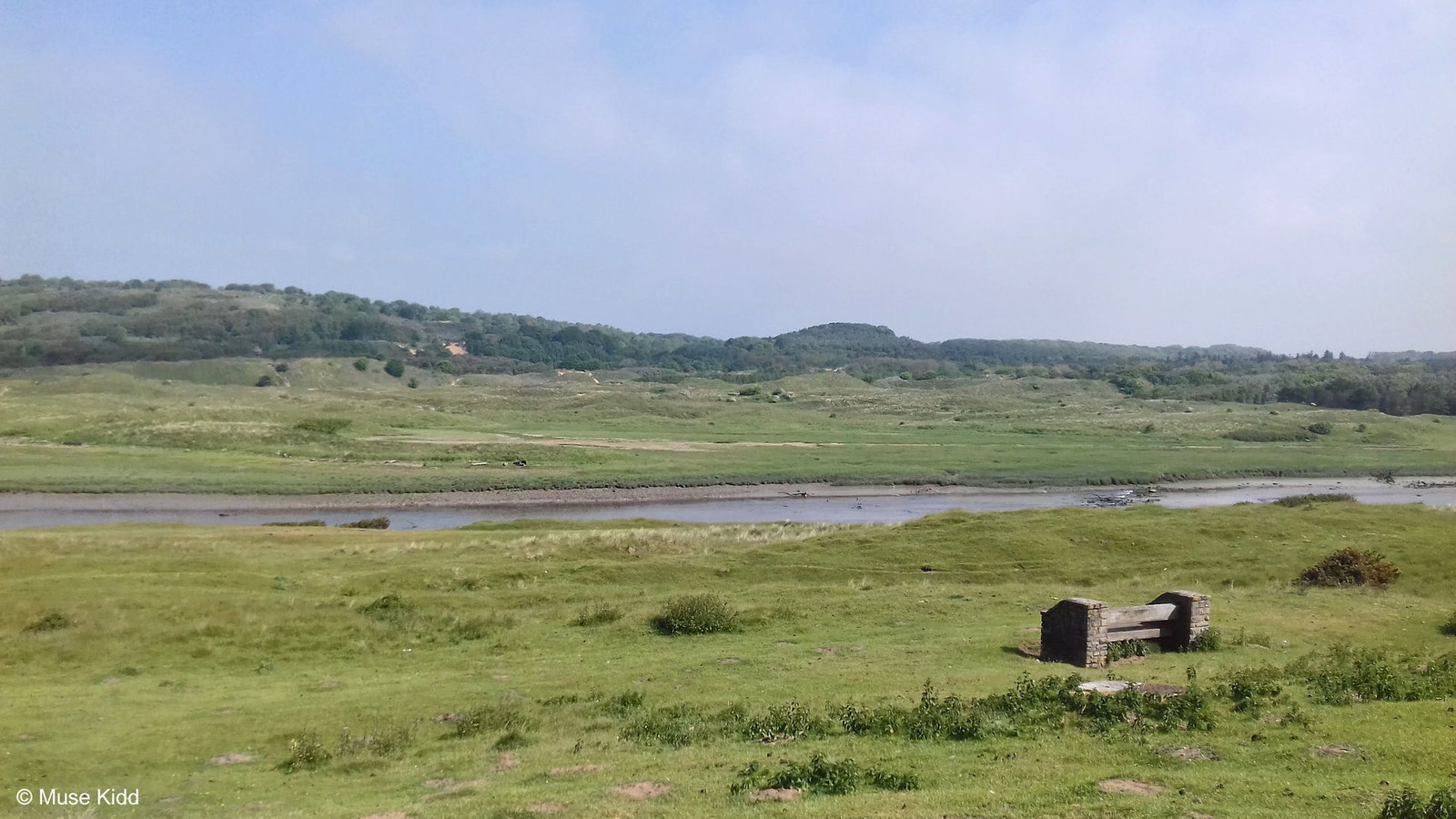
I stopped and wandered around the beach some, but I was concerned about much time I had spent exploring the castle. I could have drifted about all day. My plans were to return home that afternoon. So that's another reason to go back!
I stopped and wandered around the beach some, but I was concerned about much time I had spent exploring the castle. I could have drifted about all day. My plans were to return home that afternoon. So that's another reason to go back!
| ▲ Back to |
| ROUTE COLOUR KEY: | Traffic-free | Quiet Road | Shared Use | Steep Hill |
The route down B4245 to Southerndown is gorgeous. The views looking out over the Bristol Channel are stunning. Of course, it was a Monday morning, after rush hour, so traffic was very light which was a big plus.


It's so very quiet...
 |
| And now it's time for lunch... |
I had cycled 35 miles, wandered around a castle, and then sat down by the road for lunch. It was not quite noon.
 |
| Heading up the road toward Southerndown... |
 |
| The hills drop dramatically into the sea... |
 |
| This is farm country... |
 |
| Gratuitous bike shot with sheep and the sea... |
I can't help but think that if this were in America, there'd be houses and condiminums, hotels and shopping centers, developments piled upon more developments completely obliterating the view. Here; sheep and cattle rule.
 |
| Across the road, looking inland... |
 |
| It's warmed up nicely now... |
Then I have to get on a fairly busy road for a few miles. It's shocking and a bit frustrating. Cars zoom past whipping up heat from the road.
 |
| I wait a few moments to let cars pass and just gaze. Bees are buzzing like mad. |
 |
| But soon enough my route turns inland at St. Brides Major... |
| Sidebar of Note:
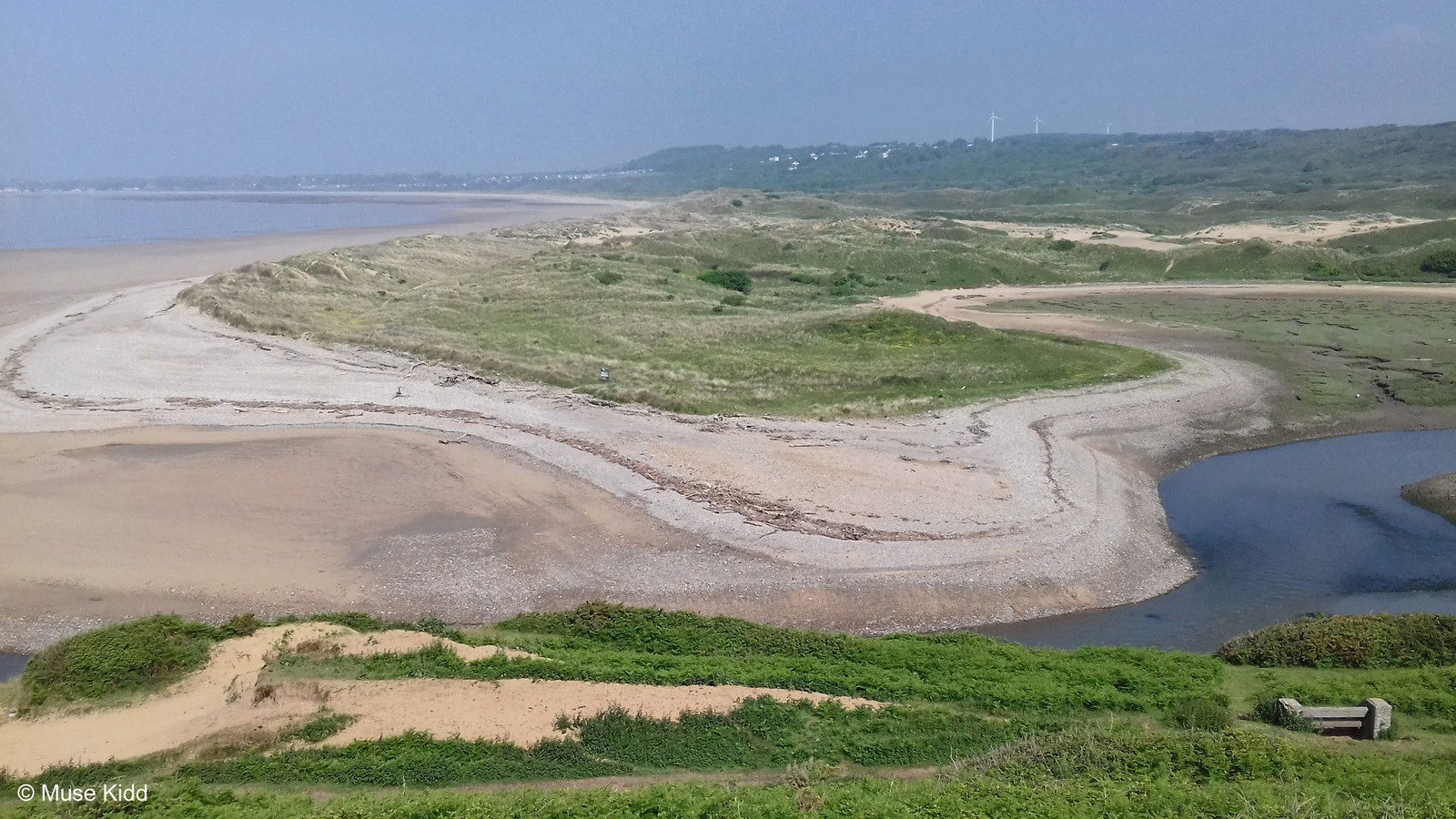
It wasn't until I came home that I realised precisely where I was and specifically what I had missed! This area is known as the Glamorgan Heritage Coastline. It is the southernmost tip of Wales and stretches for 14 miles, from Aberthaw to Porthcawl. My photos are from high above the shoreline itself and I missed all of what lays below.       |
 |
| Loving the small lanes... |
At Monknash I joined the proposed NCN Route 88 heading east toward Llantwit Major; my mid-way point (roughly 54 miles). It was my second stop. I wanted to get a coffee in one of the three shops I passed, but they were PACKED! So I sat on a wall outside of town and had another sandwich.
Note: As I cycled along, I passed several signs for NCN Route 88 and NCN Route 888. I had not planned to cycle them and I'm unsure of how well they are marked. The Sustrans site lists Route 88 as a "proposed" route and barely mentions Route 888.
 |
| Signs of civilisation... |
 |
| Communities start to take a more "gentrified" appearance... |
 |
| Incredibly quaint Llantwit Major... |
 |
| Nope... don't need you today! |

Looking across a lagoon by an abandoned quarry near Roose...

STAGE THREE
ON ROAD |
Porthkerry to Oakdale |
Distance: 44.6 miles / 77.17 kilometres
Elevation: +2,383 ft / -1,698 ft
Elevation: +2,383 ft / -1,698 ft
I don't know if I chose the best way to return to Cardiff. After I left Boverton I entered B4265 and those 4.5 miles were pretty tough. The road is mostly uninteresting and traffic is fairly heavy. I exited onto Fontygary Road and headed back to the coastline.
Planes overhead indicated that I was nearing Cardiff airport. I was getting tired and my mood was somewhat miserable and I still had a long way to go.
Planes overhead indicated that I was nearing Cardiff airport. I was getting tired and my mood was somewhat miserable and I still had a long way to go.
| ▲ Back to |
| ROUTE COLOUR KEY: | Traffic-free | Quiet Road | Shared Use | Steep Hill |
Traffic picked up and I wasn't really enjoying the ride at this point. I was unfamiliar with the area and dreading more than 20 miles of traffic to get me through Cardiff. I had no idea what was ahead.
 |
| Heading into Porthkerry Country Park... |
However, NCN Route 88 becomes traffic-free as you approach the Porthkerry Viaduct...


It was quite a surprise to see the beach in Porthkerry Park. Looking across the Bristol Channel was stunning. Oddly, finding this little jewel gave my attitude a boost.


The afternoon was setting in... the day was at its warmest. I was feeling the 65 miles and eight hours on the road. I could have stayed longer, but I needed to move on.
The next section is a combination of busy roads and shared-use walking/cycling paths as the route takes me through Barry to Penarth and Cardiff. It can be difficult.
The next section is a combination of busy roads and shared-use walking/cycling paths as the route takes me through Barry to Penarth and Cardiff. It can be difficult.

Suddenly I was in Penarth overlooking Cardiff Bay...

I made my last stop on the barrage crossing the bay. The celebrations were beginning for the Volvo Ocean Race. I took a few rather uninspired photos as I passed through, but to be honest, I was beat tired. I had cycled nearly 75 miles and I had roughly 35 more ahead of me.


And then I was heading home. It's zig-zag route through Cardiff and a series of dodging and weaving through non-descript housing estates to reach Newport. I've cycled it so often, that I didn't think to take many photographs (or I was just too tired... I don't recall, actually).
 |
| A restored barn along NCN Route 88 outside Marshfield... |
 |
| Further down the reen near Newport Golf Course... |
Summary: Ogmore-by-the-Sea Odyssey
I designed this route purely from studying Google maps. Overall, I enjoyed it, but now looking at the "proposed" NCN Routes, I will definitely follow NCN Route 88 around Roose on my next trip. B4265 is not a pleasnt ride.
Note: I've updated this report (Feb. 2022) and just looking at the photos and remembering the ride, I am anxious to return. My thoughts are that I'd like to make it a two-day ride with camping at one of the sites along the coast. See: Heritage Coast Camping
Note: The map above is interactive! You may select a tab to view each specific stage of the overall route.
I rolled my bike through the back garden gate around 8:30 pm. I had been on the road for over 14 hours. I had cycled over 100 miles and though I don't place a lot of importance on distances, this was a big one.
I was beat tired and didn't even think about my bicycle the following day.
I hope you enjoyed this little write-up and as always, thanks for spending your time with me & Bike Wales.
Cheers! - muse kidd
I was beat tired and didn't even think about my bicycle the following day.
I hope you enjoyed this little write-up and as always, thanks for spending your time with me & Bike Wales.
Cheers! - muse kidd
|
|
|||
| Ride Name: | Ogmore-by-the-Sea | ||
| Start Date: | Mon. May 28, 2018 | ||
| Starts in: | Oakdale, Wales, GB | ||
| Departed: | 6:03 am | ||
| Distance: | 109.5 mi / 176.22 km | ||
| Elevation: | + 5932 / - 5932 ft | ||
| Max Grade: | 11.1% | ||
| Duration: | 14:13:59 | ||
| Move Time: | 14:13:59 | ||
| Stop Time: | 04:39:58 | ||
| Max. Speed: | 31.5 mph | ||
| Avg. Speed: | 11.4 mph | ||
| Weather: | sun, sun, & sun | ||
| Temp: | 22°c / 72°f | ||