If you've cycled between Monmouth and Abergavenny, chances are that you've seen the little blue signs with a bicycle and four castles. Four Castles bicycle route is not well-publicized and it's a bit of challenge, but the rewards are well-worth the effort.


- 2022 -
Overview: Three Castles Tour
Date: 17 July 2022
Total Distance: 88.3 miles / 142.11 kilometres
Total Elevation: + 6244 / - 6244 ft
Duration: 16 hours, 0 mins.
Total Distance: 88.3 miles / 142.11 kilometres
Total Elevation: + 6244 / - 6244 ft
Duration: 16 hours, 0 mins.
You're probably wondering why I've called this report "Three Castles Tour", if in fact, there are four castles? My tour begins in Abergavenny; yet, I have chosen not to include Abergavenny Castle. This is because the other three; White Castle, Grosmont Castle, and Skenfrith Castle, form a historically significant "Trilateral" — that is, a common development and shared history that lasts to this day. The significance of these three medeval fortresses is outlined in my report below.
Note: You may view images from Abergavenny Castle in my gallery from an earlier visit in 2019.

White Castle

Grosmont Castle

Skenfrith Castle
An additional point to clarify, is that I didn't follow the exact Four Castles Route (shown below). I utilized many sections of the signed route, but I modified the first part by taking a more direct route to White Castle and then halfway to Skenfrith Castle, I changed direction and followed the route going to Grosmont secondly.
A final point I should make is that, because I started my ride nearly 30 miles south in Oakdale; I planned my Three Castle Tour to be slightly shorter and somewhat easier.
A final point I should make is that, because I started my ride nearly 30 miles south in Oakdale; I planned my Three Castle Tour to be slightly shorter and somewhat easier.

The "proper" 4 Castles Cycle Route as mapped by Richard Shep using Ride with GPS
My goal was to make my ride leisurely whilst allowing enough time at each location to freely wander about and take pictures. This was going to be a long day and I didn't want to worry with checking my watch — no schedule or time frame, just destinations!
I will warn you now... this is a very long read. I have divided the main route into four parts (shown in the map below) and divided the text accordingly. There are a total of 154 photos covering both the route and the castles. Additionally, I have written several small sidebars briefly describing the history of each castle.
I will warn you now... this is a very long read. I have divided the main route into four parts (shown in the map below) and divided the text accordingly. There are a total of 154 photos covering both the route and the castles. Additionally, I have written several small sidebars briefly describing the history of each castle.
Note: By default the map displays all four parts of the Three Castles Route. You may select an individual section to view a specific mini-map. You will also find each mini-map included within the four main parts discussed below.
PREFACE | Getting to the Start - Oakdale to Abergavenny | 29 miles
A brief recap of the start and the route I took to Abergavenny. Also included is a short sidebar on the history of these three castles and their unique relationship; The Three Castles
A brief recap of the start and the route I took to Abergavenny. Also included is a short sidebar on the history of these three castles and their unique relationship; The Three Castles

The beginning of my tour including photos and descriptions of the route.

The second part of my tour including photos and descriptions of the route.

The third part of my tour including photos and descriptions of the route.

The last part of my tour including photos and descriptions of the route as I return to my starting point in Abergavenny.
SUMMARY | Returning Home - Abergavenny to Oakdale | 25.2 miles
A look back at my long day in the saddle.
A look back at my long day in the saddle.
PREFACE
| NCN | 467 | 46 |  |
Oakdale to Abergavenny |
Distance: 29 miles / 46.67 kilometres
Elevation: + 1,566 ft / -2,084 ft
Elevation: + 1,566 ft / -2,084 ft
I started my day early, leaving the house at around 6:00 am and making my way up through Sirhowy Valley from Oakdale to Tredegar following NCN Route 467. I then joined NCN Route 46 heading northeast across the Heads of the Valley to Brynmawr. From there I joined Blackrock Road dropping down the valley through Clydach to Gilwern, where I continued along Abergavenny Road (B4246) into Llanfoist.
From Llanfoist it was just a short hop onto NCN Route 46 again and into Abergavenny where I followed the little red signs through town to the train station.
I didn't take any photos during my early morning start because I've documented this route numerous times and my primary goal was to just get to Abergavenny quickly. Once I left Abergavenny, I planned to photograph my ride and each of the castles.
I didn't take any photos during my early morning start because I've documented this route numerous times and my primary goal was to just get to Abergavenny quickly. Once I left Abergavenny, I planned to photograph my ride and each of the castles.

Having made my way through town to the train station to where I plan to "officially" begin my ride, I had hoped to have some coffee at the little cafe, but alas, I was too early.
So before I get started with my Three Castle Tour, let me take a moment to provide a short bit of history to put my ride into context.
So before I get started with my Three Castle Tour, let me take a moment to provide a short bit of history to put my ride into context.


For more information, be sure to check out: CADW - Places to Visit, The Trilateral of Skenfrith, Grosmont and White Castle, The Castles of Wales, Anglo-Norman Castles - Paul Martin Remfry, and Ancient and Medieval Architecture. Of particular use was the guidebook; The Three Castles, published by Cadw and available for purchase online.

It was a lovely warm July morning. The air was crisp and clear and with the exception of a few dog-walkers and joggers, I had hardly seen a soul.
I looked around and took a few photos, but not much was happening. So with a shrug, I climbed back onto my bike and said to myself; "Let's get going".
I looked around and took a few photos, but not much was happening. So with a shrug, I climbed back onto my bike and said to myself; "Let's get going".
| ▲ Back to |
PART ONE
ON ROAD |
Abergavenny to White Castle |
Distance: 7.9 miles / 12.71 kilometres
Elevation: +829 ft / -546 ft
Elevation: +829 ft / -546 ft
I left out from the station on Old Ross Road (B4521). The first couple of miles fluctuate between 4% - 8% incline, which I find particularly difficult at the start of a ride. But heading out of Abergavenny is an uphill challenge regardless of which direction you go or which road you choose. One must simply get on with it.
| ▲ Back to |

A group of weekend warriors soon passed me with such speed, it was as if I was going the other way! They all spoke as they flew by, which was nice and it motivated me to slog on.

I stopped about a mile up the hill to rest my legs and take a photo of this old watering trough (photo above). I wonder if it was placed here specifically because it's halfway? The carving reads; "A righteous man regardeth the life of his beast", from Proverbs 12:10.


Another mile further and the road leveled out becoming a series of easily cycled rolling hills. The day was looking marvelous too.


I missed another coffee stop three miles out of town at Llanddewi Skirrid. (How cute!) But the road bekoned and I rode on.


I soon realised that I was cycling along a high plateau. Wide fields and working farms fell away from both sides of the roadway.


And then I discovered a scenic overlook just past Llanvetherine. You don't see many of these now. (This one seemed hardly used. Strewn with litter and signs of a car fire implies kids and late night drinkin' followed by visits from the police.)
I remember many afternoon drives in the country as a child with my grandparents. We'd pullover at a lovely spot such as this and have a picnic. You don't hear of folks going for "Sunday drives in the country" any more. Kinda sad really, but perhaps this is why I enjoy cycling in the country so much as adult?
I remember many afternoon drives in the country as a child with my grandparents. We'd pullover at a lovely spot such as this and have a picnic. You don't hear of folks going for "Sunday drives in the country" any more. Kinda sad really, but perhaps this is why I enjoy cycling in the country so much as adult?


A mile further up the road I spot this lovely "lived-in" cottage. So many old homes in this part of the country have been "gentrified". Wealthy city-folks retire, move out to the country, buy an old farm, and a few years later the place looks like it belongs in a magazine... quaint, picture-perfect — and just like so many other places.
This house, to me, looks "real". It's lived in by real people with real lives. The back door is flung open and I can hear kids laughin' and a dog barkin' inside. That porch needs a good paintin' and the rickety clothes line is just a step away in case it rains. The grass has been mowed, but the flowers have been left on their own for awhile. This house has a story. I love it.
This house, to me, looks "real". It's lived in by real people with real lives. The back door is flung open and I can hear kids laughin' and a dog barkin' inside. That porch needs a good paintin' and the rickety clothes line is just a step away in case it rains. The grass has been mowed, but the flowers have been left on their own for awhile. This house has a story. I love it.

But the road bekons...


It's a slow and easy ride. There's hardly any traffic as I drift up and down the hills, my mind lost in thought. When just around the bend I spot the sign for my first destination. I've cycled roughly seven miles from Abergavenny and now I'm excited again.


I turned off Old Ross Road and dropped down a short hill to discover the stunning Croft Barn at Whitecastle Vineyard (photo above). Although, I didn't see the vineyards themselves, across the road, the view over the valley is incredible. I had no idea I was so high.


And then I began a long slow slog up a winding lane. I imagined medieval soldiers marching up this hill, loaded down in chain mail, marching toward an uncertain future.

Perhaps I was spoiled by the rolling countryside, but the zig-zagging and weaving up the narrow lane was exhausting. I stopped several times to to take a photograph, using the break as an excuse to catch my breath!

When I finally reached the summit, the view looking back across the hillside displayed the high ridge I had climbed. And directly ahead of me stood the infamous castle itself.

Touring White Castle
There is no visitor centre or gift shop. There are no guides to provide historical details or answer questions. White Castle stands alone overlooking the wide Monnow Valley, empty and desolate on the summit. You can walk right in and wander about as you would like. The gates are open daily 10am–4pm. Entrance is free.
| ▲ Back to |

Surprisingly, I found quite a few tourists visiting the castle, nosing around, peeking though arrow slits, like myself. As I stopped to take the photo below, a small group formed around me asking friendly questions. (They were all very interested in my bicycle journey, as well as rather shocked to hear of my plans for the day.)

I spent the remainder of my time at White Castle exploring, taking photos, and trying hard to not get any people in my shots (which is harder than you might think!)
 |
| White Castle © Crown copyright |

For more information, be sure to check out: CADW - Places to Visit, Wikipedia / White Castle, The Castles of Wales, Anglo-Norman Castles - Paul Martin Remfry, and Ancient and Medieval Architecture
| ▲ Back to |

Outer Ward and Moat
Standing at the entrance to the outer ward, the massive curtain wall for the inner ward towers to my left, while a massive stone-lined moat clearly seperates the two halves of this mighty fortress (above & below).


The gatehouse to outer ward is much smaller in comparison (above). And while much of the outer ward walls have been compromised, evidence of a significant portcullis is clearly visable (below).


The first thing you notice when entering the outer ward is its size. It feels huge. The shorter walls mostly remain intact and details within the towers are still clearly evident.
Slightly off-topic; The grass was mowed and there were several picnic tables scattered about. Overall the site is surprisingly well-maintained... good job CADW!
Slightly off-topic; The grass was mowed and there were several picnic tables scattered about. Overall the site is surprisingly well-maintained... good job CADW!


Depsite its ruiness state, I find it fascinating to stare into these towers, visualising how staircases ran and fireplaces stood. Square holes in the walls make it clear to see where floor joists once ran and rooms were supported.


Stepping through a large broken section of the outer ward wall and down to the lower ground level, the moat which surrounds the inner ward becomes much more impressive and its defensiveness more significant.


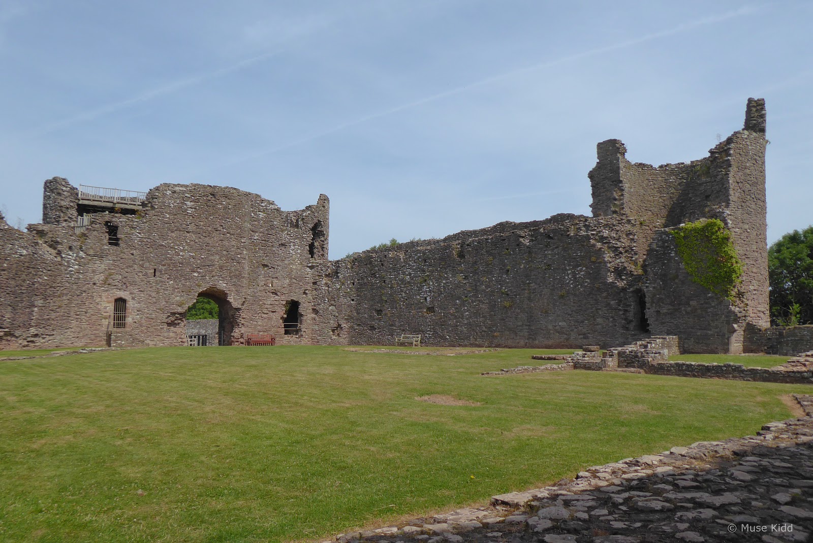
Inner Ward
Let us now leave the outer ward, across where a mighty drawbidge once stood, passing through the main gatehouse and between its massive twin-towers.


Nothing from the entrance at the main gatehouse indicates what lies within the inner ward. The shear size of the curtain walls and what remains of the towers completely dwarf those found in the outer ward.

The southern curtain wall stands at the far end of the inner ward (image above). This was once the main entrance into the castle, but during the early 13th century Hubert de Burgh, Earl of Kent re-orientated the castle by constructing the great northern gatehouse.
Additionally, the southern gatehouse and keep were demolished and replaced with the Chapel Tower and a new single D-shaped ‘Great Tower’. They were then joined by a single massive curtain wall, effectively closing off the southern end (what we see today). However, remnants of the original keep and gatehouse can still be seen (image below).
Additionally, the southern gatehouse and keep were demolished and replaced with the Chapel Tower and a new single D-shaped ‘Great Tower’. They were then joined by a single massive curtain wall, effectively closing off the southern end (what we see today). However, remnants of the original keep and gatehouse can still be seen (image below).


Looking into bottom of the the ‘Great Tower’ (above).

Looking into the remains of the Chapel Tower (above) and a detail showing the distinctive (and unique) off-centre arrow slits (below).


Foundations of the chapel and castle well are visable (above left) whilst remains of the castle brew house can be seen at the other end (above right).
Looking north toward the inside of the great gatehouse (above and below). Unfortunately, the stairs leading to the top of the gatehouse were closed (needing repair), but maybe they'll be sorted next time!


Crossing the barbican, looking into the moat as I make my escape (above and below).


Looking back from the Outer Gates (above) and then on the road again, leaving the summit (below) as I begin my ride to Grosmont.

Imagining myself a messenger, sent by the lord of the castle with urgent news for the garrison at Grosmont. Without haste, I begin my next adventure!
PART TWO
ON ROAD |
White Castle to Grosmont Castle |
Distance: 6.9 miles / 11.10 kilometres
Elevation: +685 ft / -861 ft
Elevation: +685 ft / -861 ft
Looking at my map, I am pleased to see that it's just a short ride to Grosmont. I've not cycled this route before, so I'm curious and excited.
| ▲ Back to |
Partially hidden by the tall summer grass, the Four Castles sign points my way (below). I am quietly thankful to see that my route continues across this high ridge.


Further up the road, a fabulous carved eagle looms over a reen. I love discovering things like this, but I wonder who else would ever see it way up here?


The lanes are much more narrow along this stretch. I can hear a tractor putt-putting along somewhere over the hedge, but I haven't seen a car in ages.


It's lovely and quiet. The cycling is easy and I stop regularly to look around and take photos. I turn a corner and in the distance I can now see the Skirrid (below).


"Arty" photo included at no extra charge.

Those clouds in the photo above have a name, but I cannot find them?

Roughly three miles up the road I rejoined Old Ross Road (B4521); the same one I rode out of Abergavenny (above); however, it wasn't for long...

... because in less than a mile I reached the village of Cross Ash and I changed my route again. By heading north to Grosmont first, I would avoid an arduous climb to Skenfrith. (An advantage of using a mapping/routing website prior to your ride!)


Continuing along the high ridge above the Monnow Valley, I can confirm that I'm on the Four Castle route, but I'm just cycling the route in the opposite direction (below).


The views are fabulous.

Quiet and desolate, the road moves under the trees as it descends slowly into the valley.


Another lovely home along the valley floor (above). I turn the corner and see that I'm getting close to Grosmont when I spot the steeple of Church of St Nicholas (below).

However, the keyword here is "steep", because the last tenth of a mile is quite a climb (±11%) up to the high street in Grosmont.


Touring Grosmont Castle
Grosmont Castle stands tucked behind the houses of the village in a modest field overlooking the valley. Once again, there is no visitor centre or gift shop. The gates are open daily 10am–4pm and it's free to enter.
| ▲ Back to |

From the very start, it is clear to see that this castle is much smaller and less formidable than White Castle. (It's almost cute in comparison.) Let's have a look around...

First; a short bit of history, then let's have a look around...
 |
| Grosmont Castle © Crown copyright |

For more information, be sure to check out: CADW - Places to Visit, Wikipedia / Grosmont Castle, The Castles of Wales, Anglo-Norman Castles - Paul Martin Remfry, and Ancient and Medieval Architecture
| ▲ Back to |


Whereas White Castle had a massive stone lined moat, Grosmont merely has a large ditch.

Also, the castle seems to be of two halves; the left is more typical with curtain walls and towers (above). Whilst the right side appears to be a single structure with massive walls interspersed with windows, almost like a large house (below).


The inner ward is very small, yet there are the remains of several structures along the left wall, indicating that the inner ward must have seemed even smaller in its day.


The large gate tower is still relatively intact with stairs leading to the top of the remaining curtain wall.

I wouldn't recommend climbing up if you're scared of heights. The views are amazing, but the walkway is very narrow and the handrail is quite low.
It wasn't long ago that I was looking up at that church steeple (below).
It wasn't long ago that I was looking up at that church steeple (below).


From this vantage point, the structure across the inner ward does in fact, seem to be a single large structure of two stories which was then divdied into mulitple rooms (above).


But of all the elements that characterise Grosmont Castle, the towering chimney at the far end of the inner ward stands out as the most unique (photo above).


Leaving the inner ward, I then walked out to explore the grounds surrounding the castle.


The castle is perched on a small knoll and the surronding hillside falls away steeply outside the ditch.


Trying to get all "arty" again. Set against the bue skies, the tall grass, wild garlic and buttercups, I find the views exceptionally romantic.


And with one last parting shot, it's time to leave...
PART THREE
ON ROAD |
Grosmont Castle to Skenfrith Castle |
Distance: 5.1 miles / 8.20 kilometres
Elevation: +333 ft / -536 ft
Elevation: +333 ft / -536 ft
Heading south out of Grosmont along the High Street (B4347), the road is quite narrow and by the early afternoon, traffic was starting to pick up a bit. However, this is the shortest leg on my tour so I should be arriving in Skenfrith within the next 30-45 minutes.
| ▲ Back to |
The first half mile is a rather steep descent, but as soon as it levels out, the road is lovely. The route then begins a slow climb, but it's not too hard. You can easily take your time and enjoy the scenery.


This is what cycle touring is all about. This is what I want to see, where I want to be.


And still, the road bekons...


The air is warm and dry and filled with the smell of hay and wild garlic.


The afternoon sun is high. Insects are buzzing back and forth across the lane. I could stand here for hours, just watching, seeing, breathing it all in.


The lane is full of small details. My mind imagines the writing of children's stories.

Just as I was entering the village of Skenfrith from the western side, I passed the very handsome St. Bridget's Church (below). Dating back as far as 1166, this Grade I listed medieval building is as old as the castle standing to its side and yet it is still an active parish church.

Had I known about this church before embarking on my little adventure, I would have certainly explored it more. Another reason for another visit.
Touring Skenfrith Castle
The first feature that is noticably different as you approach Skenfrith Castle is it's low position along the valley floor. Whilst White Castle and Grosmont are perched high upon hills overlooking the Monnow Valley, Skenfrith Castle is sitting right along the Monnow River itself.
And again, as with the other two castles, Skenfrith has no visitor centre or gift shop. The grounds are open daily from 10am–4pm and it's free to enter.
And again, as with the other two castles, Skenfrith has no visitor centre or gift shop. The grounds are open daily from 10am–4pm and it's free to enter.
| ▲ Back to |

The second thing I noticed as I cycled up to the entrance, was the large number of people that had come out to picnic, sun-bathe, and simply relax around the grounds of the castle.
There were people almost everywhere — which I found equally shocking and somewhat frustrating. I had wanted to wander around and photograph as I pleased, but it was not to be the case on this day. Let's take a moment to read some history...
There were people almost everywhere — which I found equally shocking and somewhat frustrating. I had wanted to wander around and photograph as I pleased, but it was not to be the case on this day. Let's take a moment to read some history...
 |
| Skenfrith Castle © Crown copyright |

For more information, be sure to check out: CADW - Places to Visit, Wikipedia / Skenfrith Castle, The Castles of Wales, Anglo-Norman Castles - Paul Martin Remfry, and Ancient and Medieval Architecture
| ▲ Back to |


The photos I have here are an odd assortment. I tried as best I could to capture the castle whilst not photographing any people, but I wasn't very successful. Children were running about wildly everywhere.


Some shots work, as with the main keep from the back (above). But the back wall facing the river (below) is hard to relate to the rest of the castle.


The river access is one of the more unique elements to the castle (inside above and outside below).

In fact, there are several unique elements to Skenfrith Castle, however; I simply couldn't photograph them with all the kids running about.

I took the photo above whilst standing on the front castle stairs looking out across the lawn. Perhaps I was just tired, but I found the situation quite exasperating. Looking back now that I've returned, I should have included the people. It was such a unique experience.


Then as I was leaving, I discovered a couple of buldings just outside the castle, seemingly ignored and mostly over-looked by the visitors, yet I found them exceptionally intriguing and full of character.


Looking back over my shoulder as get on the road again (above), there's a monument in the distance I failed to investigate and another watering trough. I definitely need to return.
PART FOUR
ON ROAD |
Skenfrith Castle to Abergavenny |
Distance: 12.7 miles / 20.43 kilometres
Elevation: +1,081 ft / -985 ft
Elevation: +1,081 ft / -985 ft
It was late in the afternoon as I pulled out of Skenfrith. I was tired and ready to get away from the crowds. Fortunately, it is only a little over 12 miles back to Abergavenny.
Surprsingly too, as I was was getting on the road, I met another couple who were out cycling for the day, so we pedaled along, chatting together for a couple of miles before they turned off toward Grosmont.
Surprsingly too, as I was was getting on the road, I met another couple who were out cycling for the day, so we pedaled along, chatting together for a couple of miles before they turned off toward Grosmont.
| ▲ Back to |
I should have taken a photo or gotten their names, at the very least, but I was dragging by this point and not thinking about much more than getting home.

I look up and see the Skirrid along the horizon again (below).


It's a shame too that I was feeling so tired because the light became quite lovely in the late afternoon. My head was hanging low and my mind was someplace else.


Fortunately, all I had to do was sit back and relax as the last couple of miles are a wonderfully fast and easy glide into Abergavenny (above and below).

The wind and the speed and the notion that this part of my adventure was nearing an end revitalised me somewhat, yet I had nearly another 30 miles ahead of me.
Summary - Three Castles Tour
It was well after 6:00 pm when I pulled into Abergavenny. I was tired. I was sweaty. I was a worn out boy. I stopped at the Tesco petrol station and bought myself a chicken pasta salad, a big bag of crisps, and two bottles of sugary soda.
I then cycled a short distance to the entrance of NCN Route 46 in Llanfoist and plopped down on the ground. For 45 minutes I just sat there and stuffed my face. My day was far from over.
My original plan had been to take the Monmouthshire & Brecon Canal back to Pontypool, but as easy as that route is, it is much longer. I was ready to be home, so I decided that I'd take the harder, but shorter route climbing up through Clydach Gorge. Still, it would take me another four hours to reach home.
If you are unfamiliar with Clydach Gorge, check out Part Two of my route; Clydach Gorge. It's a slog, but a beautiful slog. I didn't have any creative juices left in me for the camera on the ride home.
Looking at the ride Report Card (shown on the right), you'll see that my total distance was over 88 miles, I climbed over 6,200 ft. and my ride duration lasted over 16 hours. It was dark when I pulled into our back garden. I don't remember much after that.
It had been a magnificient day — one of my biggest, single day events, and one that I'll be hard pressed to surpass.
If you made it this far, Thank you! I hope you enjoyed this lengthy report.
Seeya down the road... Cheers! - cm
