An exploration for a future ride and campout

I had a notion floating around in the back of my mind that I'd like to cycle across the Brecon Beacons (now called Bannau Brecheiniog). It would take several days to complete and I was unsure of my route. This was my first exploration of what would become the first leg of that journey.
Overview: Talybont-on-Usk [ explore ]
Date: 02 October 2022
Distance: 74.3 miles / 119.57 kilometres
Elevation: + 3,814 / - 3,814 ft
Duration: ±12 hours
Distance: 74.3 miles / 119.57 kilometres
Elevation: + 3,814 / - 3,814 ft
Duration: ±12 hours
There is a specific cycle route across the Brecon Beacons National Park; Cycle Across the Beacons. It was designed by the folks at Sustrans and it starts in Llandeilo, on the western edge of the park and travels east to Abergavenny.
My dilema was that I wished to go the other direction; starting in Abergavenny and traveling west to Llandilo. The website noted above, provides some basic guidance, but the map (now missing from the site) was completely useless. The site seemed as if it hadn't been updated in a while, which is not terribly surprising. I would, therefore, need to plot my own course.
This was a good exploration of the M&B Canal between Gilwern and Talybont-on-Usk and the beginning of my design for a route across the Brecon Beacons National Park.
I set out with what I thought was a modest goal: to cycle to Brecon along the Monmouthshire & Brecon Canal towpath (NCN Route 49) and return. I had cycled this route previously and it seemed reasonable to achieve.
What I didn't consider was the time it would take. Between the distance, my photography, and the obstacles I encoutered, I wholly underestimated this journey.
What I didn't consider was the time it would take. Between the distance, my photography, and the obstacles I encoutered, I wholly underestimated this journey.
Brynmawr to Gilwern
I had several options on how to first reach the Monmouthshire & Brecon Canal. The fastest and easiest way from Oakdale is to cycle over to Pontypool, but then I'd be on the canal path for a very long time. I wanted to start further up and avoid much of the meandering between Pontypool and Gilwern.
I decided to cycle north up the Ebbw Fach Valley along NCN Route 465; from Aberbeeg to Brynmawr. This would put me at the Heads of the Valley where I could then easily drop down to Gilwern and join the canal.
I decided to cycle north up the Ebbw Fach Valley along NCN Route 465; from Aberbeeg to Brynmawr. This would put me at the Heads of the Valley where I could then easily drop down to Gilwern and join the canal.

This sleepy town at the Heads of the Valley is a common stop for many of my rides. NCN Route 46 passes through here and it's a connector to NCN Route 492 as well.
However, I've got other plans. It's less than a mile across town and out onto the old road heading down to the village of Clydach and then Gilwern.
However, I've got other plans. It's less than a mile across town and out onto the old road heading down to the village of Clydach and then Gilwern.

And this old road deserves attention, beacuse it's a fabulous ride back through time.


From Brynmawr to Gilwern, the enitire way — is all downhill. The road just weaves and drops along the valley hillside for nearly four miles.


A few sections of the roadway have been widened and re-tarmacked due to the improvements to the dual-carriageway below (A465). But for the majority of the way, it's just this lovely little road weaving down the mountain with very little traffic.


The village of Clydach feels as if it's just clinging to the side of the mountain. I can assure you too, the road is much steeper than it appears in these photos.
The Blorenge makes an appearance (above) and then a few minutes later, Sugar Loaf stands out against the horizon (below).
The Blorenge makes an appearance (above) and then a few minutes later, Sugar Loaf stands out against the horizon (below).


The main road continues downhill sharply before crossing under the A465 and onto the opposite side of the valley. But as I bear left onto Maesygwartha Road, I will continue down the northern side of the valley.


This route down from Brynmawr is not as dramatic as climbing over Llangynidr Commons (see my gallery: Llangynidr Commons II), but this way is incredibly quaint.


Looks like a mountain, but it's not! At 1,955 feet, Sugar Loaf (far off in the distance above) is 45 feet shy of having the necessary height of 2,000 feet above sea level to be officially declared a mountain.


Almost down the mountain you enter the small village of Maesygwartha. Blink and you're back under the canopy of trees for the last half mile to Gilwern.


And just like that, I'm down the mountain. I turn right at the junction (above) and immediately cross over the lovely Monmouthshire & Brecon Canal (below).

Access to the towpath is just over the bridge on the left-hand side of the road. Now it's time to begin the primary part of my adventure.

Gilwern to Talybont-on-Usk
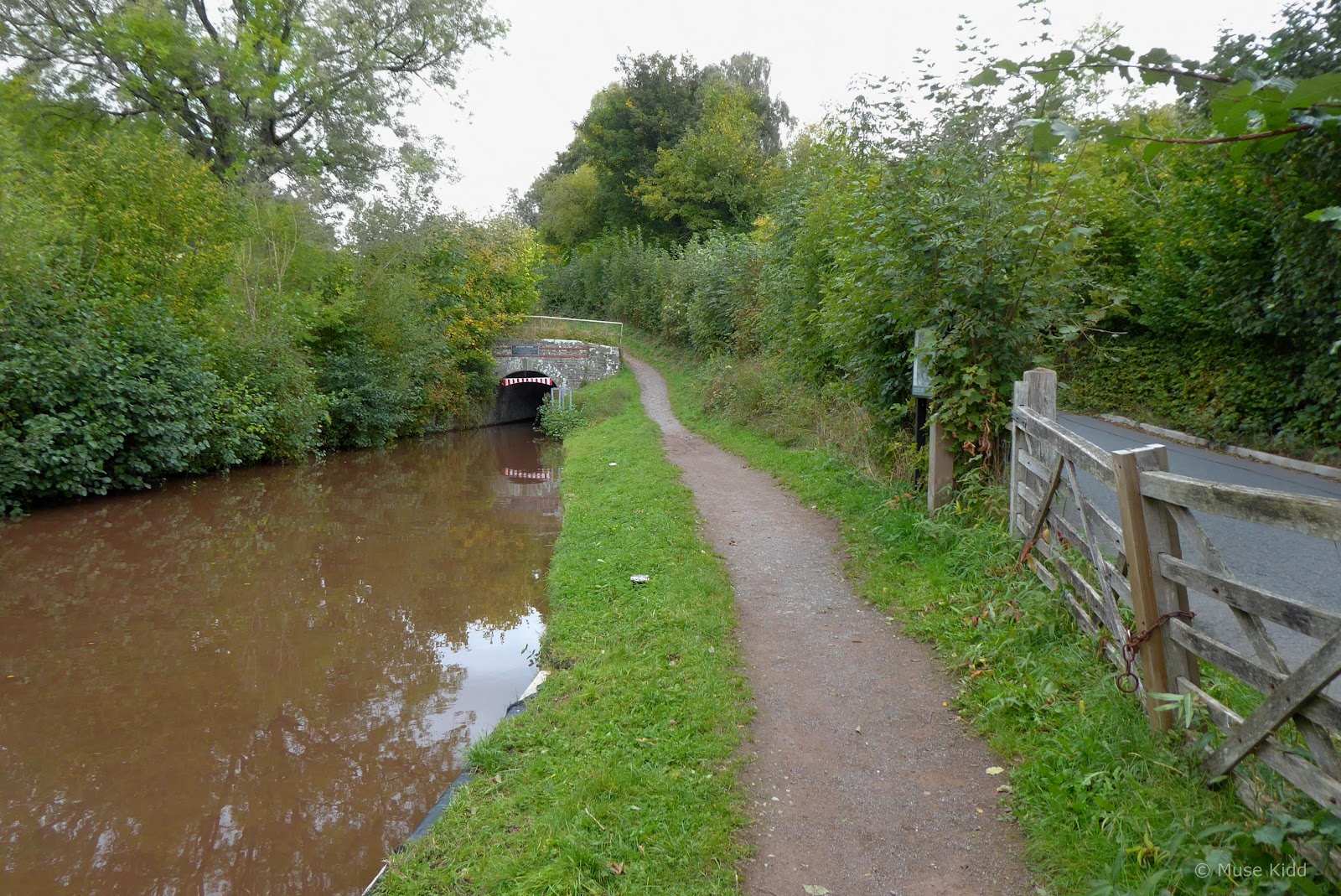
The towpath is narrow in places, but it is flat, so I can sit back and be a little lazy. The surface is mostly crushed stone (my favourite) and I've roughly 12 miles along the canal before reaching Talybont-on-Usk.


Then as I passed under bridge #113, I came across this beauty sitting right along side the towpath. Who would have thought that there is an American Giant Sequoia here in Wales?
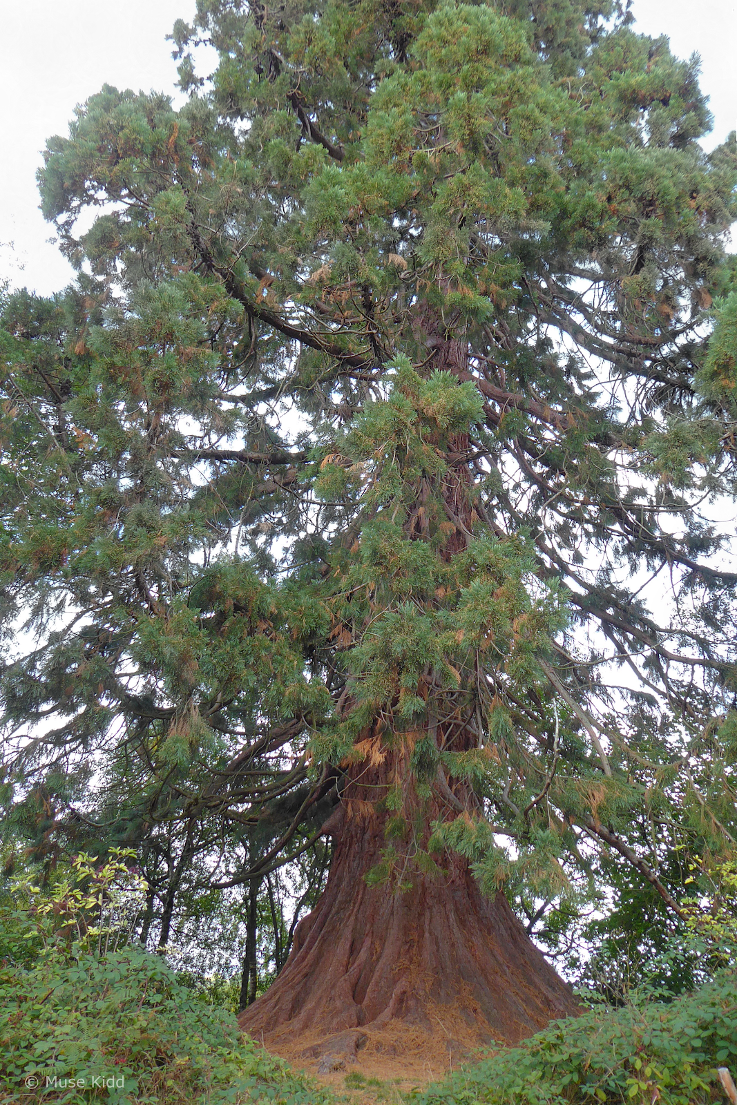
It's actually listed on the UK website for monmental trees. See: Giant Sequoia close to Bridge 113 in Llangattock, Wales, United Kingdom.


How cool is that?

Looking back at bridge #113 to record its location (below).


Ya gotta love the Canal & River Trust. Not only do they do a wonderful job taking care of this lovely canal, but they seem to enjoy the work as well (below). This little scene has a modern-day "Huck Finn" feel to me.


I think there are 4 or 5 different wharfs along the canal where you can rent narrowboats? Most of the one's here have been rented out and are puttering up and down the canal. I'd like to rent one sometime, but they're very pricey. I guess I'll just admire them from the shore.


Then just around the corner, I came across the Lime Kilns of Llangattock. I just love how they've preserved so much of the history in Wales. Places like this fascinate me. (And thank god for the Internet... It's wonderful to come home and research these places. It's no wonder why it takes me so long to publish a ride report!)


So I continue on... the path becomes rather gentrified as I approach Llangattock (above). And the estates a bit more grand, as this private footbridge suggests (below).


The view through the trees overlooking Llagattock and Crickhowell, with Table Mountain far on the horizon (above).
Bridge 118 (below) is a significant trailhead. Here the Cycle Across the Beacons route turns off the canal and drops down onto Cwm Crawnon Road (B4558).
Bridge 118 (below) is a significant trailhead. Here the Cycle Across the Beacons route turns off the canal and drops down onto Cwm Crawnon Road (B4558).


In actuality, the route along the road is quite nice. Plus, it has the bonus feature of being somewhat faster (not that it matters to me most of the time). My speed on the road is generally 12-17 mph, whilst along the canal, I'm pushing 7-8 mph.


But as you can see, the towpath ain't too shabby.


Then a couple of miles further along at Bridge 132, things get interesting again as I came up to a series of small locks just north of the village of Llangynidr.
Since getting onto the canal towpath, I've traveled a whopping 8.5 mi. and shot over 40 photographs (that's about 5 per mile and at this point I began to wonder about my time).
Since getting onto the canal towpath, I've traveled a whopping 8.5 mi. and shot over 40 photographs (that's about 5 per mile and at this point I began to wonder about my time).


But the excitement soon ended and I was back to just rolling along, enjoying the scenery.


Next, I encountered the Ashford Tunnel. It's 300 yards long and without a towpath I have to enter the roadway for a short bit.
Here's a great little video clip with it's history from the BBC: The Ashford Tunnel.

A mile further and houses started to appear again. I had finally made it to Talybont-on-Usk and I really like this little village.


There are two pubs along the canal as you come into Talybont-on-Usk; the Star Inn and the White Hart Tavern. Both offer outdoor seating and look quite festive with colourful bunting, picnic tables, and umbrellas.


However, it was Sunday and late afternoon. The village was quiet. I saw no one. As I looked around, I thought to myself; "man, this is sombre".

Brecon is 7 miles north. I looked at my watch. I cannot make it there and return home at a reasonable hour. I must turn around.

With a heavy sigh, I cycled down to the High Street and turned back through the village... looking in the windows of the houses as I passed. I wasn't ready to go. Urgh.
Talybont-on-Usk to Oakdale
I decided to take the main road (Cwn Crawnon) back to Gilwern. I wouldn't stop to take any photos and I could make up some time. Urgh.

I cycled 6 or so miles, as far as Glanusk before the rain finally came. It had been threatening most all afternoon and I had been avoiding thinking about it too much. But here it was and I was in no mood for it either. I decided to climb back up to the canal where I could hunker down under the bridges if it got too bad.

As typical for Wales and after dashing from bridge to bridge for nearly 12 miles — the rain stopped, the skys cleared, and the sun re-emerged. It was like a different day altogether.


Then as I slowly dried out, my mood changed. No longer was I worried about the weather or the time or when I got home. I even shot a few more photographs too.


The late afternoon became absolutely beautiful. I decided to let go of all my worries and to focus on one of the reasons why I cycle... to just be.


Then just as I was feeling groovy again, real-world concerns befell my adventure...

At first, it looked pretty severe, but as I got closer, I could see that other cyclists and walkers had made it through. I would need to hoist my bike quite a bit to get over some of the larger sections, but it looked doable.

However, the last bit was through a tangle of many smaller branches that proved to be the most difficult. The rain had made everything quite slippery and as I was stepping over what seemed to be a simple log, my foot slipped, snagged on an unseen branch, and I went flying. My bike inturn, hit the log I was trying to cross, ripped loose from my grip and bounced into the thicket of leaves and branches.
Fortunately, both myself and my bike avoided an afternoon swim and importantly too, I was unhurt. I'm sure it looked ridiculous. And of course, I looked around to see if anyone had witnessed my performance. It was after I had composed myself and retrieved my bike that I discovered the real casualty of my blunder.
Fortunately, both myself and my bike avoided an afternoon swim and importantly too, I was unhurt. I'm sure it looked ridiculous. And of course, I looked around to see if anyone had witnessed my performance. It was after I had composed myself and retrieved my bike that I discovered the real casualty of my blunder.

Yup. It was dead. I had bought the rubber protector thinking it would help in case of a fall, but it was pretty useless against my acrobatics.
So much for feelin' groovy. I loved my little Garmin. It had traveled thousands of miles with me all over Wales. I was gutted.
So much for feelin' groovy. I loved my little Garmin. It had traveled thousands of miles with me all over Wales. I was gutted.

And on that sad note, I climbed back on my bike and headed home. I rode the remainder of the towpath (NCN Route 49) all the way down to Newport where I then turned back up the Crumlin Arm of the M&B Canal (NCN Route 47). What a day.
Summary - Talybont-on-Usk [ explore ]
The campground was closed, so I didn't get any photos, but Talybont-on-Usk looks to be the perfect distance for the first night of a longer trip across the Brecon Beacons. There are shops, pubs and even a bike shop. Plus, I really like the vibe of the village.
Overall, it had been quite a day... full of ups and downs. The main part of the ride from Gilwern to Talybont-on-Usk had been brilliant. I didn't make it all the way to Brecon, but I made some solid research with some great photos.
Overall, it had been quite a day... full of ups and downs. The main part of the ride from Gilwern to Talybont-on-Usk had been brilliant. I didn't make it all the way to Brecon, but I made some solid research with some great photos.
The ride home was not so great. I got soaking wet and I lost all my data from the ride when I broke my Garmin. The map I've embeded here is a re-creation without the details of time and speed. I went pretty far and it was a long day.
How I record my rides going forward will need to be investigated.
Despite ending kinda down, it was a successful exploration and I hope you enjoyed my report. Thanks as always, for spending your time with me.
Seeya down the road... Cheers! - cm
How I record my rides going forward will need to be investigated.
Despite ending kinda down, it was a successful exploration and I hope you enjoyed my report. Thanks as always, for spending your time with me.
Seeya down the road... Cheers! - cm