This was a shortish training ride for a much longer effort I have planned for later in the month. I often cycle parts of this route individually, but for this ride I've combined them into a longer single route.
Overview: Pen-y-Fan Pond & 14 Locks
Date: March 17, 2021
Distance: 53.9 miles / 86.74 kilometres
Elevation: + 2985 / - 2988 ft
Duration: 8 hours, 22 mins.
Distance: 53.9 miles / 86.74 kilometres
Elevation: + 2985 / - 2988 ft
Duration: 8 hours, 22 mins.
There were no specific plans for this ride, I just left the house early and headed up to the pond above our home. As I pedaled along, I thought about where I'd like to go for the day. When I had circled the pond, I had a general idea.
I dropped down to Blackwood and turned north on the cycle path up through Coits Wood to Holly Bush. Then I simply turned around and went back as I had come. From Blackwood, I cycled out to Pengam where I entered the Nature Reserve back to Maesycwmmer. Leaving the Nature reserve, I glided down through Sirhowy Parc to 14 Locks where I once again turned around and simply came back home.
I followed a few NCN Routes, specifically; NCN Route 467 through Coits Wood from Blackwood to Hollybush, NCN Route 468 through Bargoed Woodland Parc, and NCN Route 47 from Gelligroes through Sirhowy Parc and down to 14 Locks. I was on medium to quiet roads for approximately 50% of the ride.
The weather forecast wasn't the best, but I did take my camera along and shot a few photos just for practice. Surprisingly, the day turned out rather nice and my ride quite relaxing.
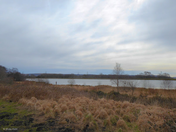
Pen-y-Fan Pond
I started cycling up to Pen-y-Fan Pond during the pandemic. It's just up the hill behind our house and makes for a nice little climb and warm-up. The only down-side is that many other folks started coming up here as well and now the small path around the pond can be rather crowded to comfortably cycle.
The pond itself is actually an old feeder reservoir for the Crumlin Arm of the Monmouthshire & Brecon Canal. There's an angler's club, as well as a small boating group that utilize the pond during the summer months. The area is managed by Caerphilly Green Spaces.
The pond itself is actually an old feeder reservoir for the Crumlin Arm of the Monmouthshire & Brecon Canal. There's an angler's club, as well as a small boating group that utilize the pond during the summer months. The area is managed by Caerphilly Green Spaces.


Had I thought about the lighting, I would have come earlier. As it turned out, I was quite pleased to have caught the last of the sunrise with some fishermen out in the water and a few geese lingering about.


The geese seemed to know I was taking their picture.


There is always a loon sitting on this post. Same one or a different one? I haven't a clue, but I always take a picture of him/her (above). And a new little pond beside has started to form beside the main pond (below).

What are these strange little grass humps? (below) They look like a group of strange creatures from the Adams Family. The lighting was just right to make them almost glow.

Quoits Wood and Hollybush
Following my short loop around the pond, I returned back down the hill to Oakdale where I continued further down the hill to Blackwood. It's a nice little drop of nearly 500 feet in just under 2 miles. I crossed the Chartist Bridge where I turned north again leaving civilisation and entered Quoits Wood.
NCN Route 467 runs uninterupted for three miles between Blackwood and Hollybush. It's a pretty isolated little route following along the old rail line of the Sirhowy Valley.
NCN Route 467 runs uninterupted for three miles between Blackwood and Hollybush. It's a pretty isolated little route following along the old rail line of the Sirhowy Valley.

If you look closely, you can make out the viaduct that once ran across the adjacent hillside (above). At one point in time trains ran on both sides of the valley... now there are none. The Abernant-y-felin Viaduct had six arches of fine cut stone and was quite attractive.
| Sidebar of Note:
Built in 1900 and buried in 1918, it was but a brief existance for the Abernant-y-felin viaduct. Servicing the Markham Colliery, the viaduct began to subside soon after it was completed, so the valley behind it was filled in. This photograph was taken at Manmoel Crossing with the old Tredegar to Newport railway line in the foreground.  Content provided by www.industrialgwent.co.uk and Argoed Community Council |

Abernant Colliery opened here in 1890 and at it's peak employed over 500 workers. By 1932 however, the colliery closed and today the council is attempting to revitalise the area with a few sparse trees and shrubs. Unfortunately, it's a popular spot for dirt bikes and atvs which run amok of the place on weekends.

You might find it interesting to take a look at a document I discovered while researching Sirhowy Valley, because it is essentially the same photographic journey I'm guiding you along today — only these images span 60 years of the late 19th early 20th centuries; A Stroll Between Argoed and Hollybush.


The opposite hillside has been clearcut for timber (above). While a mysetrious wooden figure adorns the end of the cycle path at Hollybush (below). Oddly, there is no explanation for the sculpture and we're left to wonder on the identity of this finely dressed man with his book and stout chapeau.


Turning around and heading back down the path we encounter two more totems of unknown significance. Thank you Caerphilly Council. They look very nice. May we have a bit of explanation, please?

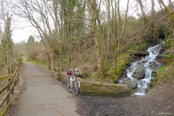
I stopped to take this photo because along the route there are many small yet charming waterfalls. It's hard to imagine this area as being an industrial landscape when it is so pristine and wooded now.
And lastly we have this fine chap. I have been told (unconfirmed) that this was once the route Druids followed on their pilgrammages north to Brecon. Could this sculpture reference that? Perhaps the council could enlighten us?
And lastly we have this fine chap. I have been told (unconfirmed) that this was once the route Druids followed on their pilgrammages north to Brecon. Could this sculpture reference that? Perhaps the council could enlighten us?


I often see older men walking along this route, carrying those odd forked sticks, perhaps they've brought along their dogs, but I haven't seen a soul today and I feel as if the valley belongs just to me.
Spring is just around the corner, but today it's still rather chilly and looks quite wintry as I ponder the lost mysteries of this ancient valley.
Spring is just around the corner, but today it's still rather chilly and looks quite wintry as I ponder the lost mysteries of this ancient valley.

Sustrans built a lovely bridge at Argoed and installed this portrait bench to coincide with the path improvements (below). It celebrates the lives of three local heroes. On the right is International Quoits Champion; Jack Price depicted playing the game, in the middle is Zephania Williams who was one of the founders of the Chartist Movement, while on the left is Mrs Jill Crandon who was head teacher at Markham Primary School for many years.


Once I was back down the hill, I re-joined the road through Blackwood along the busy High Street, through Pontllanfraith and into Pengam. It's a fairly busy road at times with several tricky roundabouts to navigate, but it's mostly flat to gentle rolling hills. Cyclists are often seen peddaling along it's sides, so drivers are aware and generally quite accomodating.
Bargoed Woodland Parc & Gelligroes
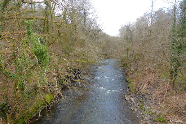
After passing a number of uninteresting industrial estates, car dealerships, and the like, I turned into Bargoed Woodland Park at Pengam to follow traffic-free NCN Route 468.
They've been working on this park for quite a while and it has changed significantly over the past few years (for the better!) It's a squirrel's nest of paths and walkways which wrap around the Rhymney River. I'll be interested to see how it progresses.
They've been working on this park for quite a while and it has changed significantly over the past few years (for the better!) It's a squirrel's nest of paths and walkways which wrap around the Rhymney River. I'll be interested to see how it progresses.

Hey Sustrans! Which way do I go? A sign sure would be helpful here (below). Fortunately, I know this route... so bear right kids! We're off to see a cool bridge!

Sitting at the base of a short hill where the two sides of the valley narrow, this lovely bit of engineering is a real showpiece of walking & cycling infrastructure. Wales excels at this.

Does this cool bridge have a name? No! Should this bridge have a name? YES! YES! YES!


This is the magnificient River Rhymney.
It's a short little loop of not much more than a mile, but it is lovely. For more photos of this stunning woodland park, be sure to check out my report: Fochriw Highlands.
I then exited the park at Fleur de Lis and re-entered the roadway for a short .5 cycle along the narrow and busy High Street.
I then exited the park at Fleur de Lis and re-entered the roadway for a short .5 cycle along the narrow and busy High Street.

Generally speaking, it's the pedestrians that make this section of particular concern. There are quite a few busy little shops, cars parked along both sides of the road, room for only one car to drive, people randomly crossing the road, opening car doors and essentially, not looking out for cyclists which makes this short section surprisingly hazardous.
Once having safely navigated Fleur de Lis, it's then another 1.5 miles to Maescymmer where I passed under the Hengoed Viaduct and climbed up onto NCN Route 47.
Here you can find another object I find myself photographing over and over; the Wheel of Drams (below). This isn't a particularly good image, but it's a popular hangout for kids and folks taking a break, so I took advantage of having it all to myself!

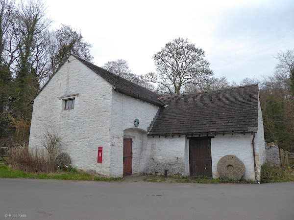
I left the cycle path again at Gelligroes where I paused at the Old Mill and Candleshop (once the candle maker for the Queen). It's an interesting place I've photographed several times before, but it holds a particular interest to me for it seems to be slowly fading out of use.


I'm sure this was once a well-groomed little garden (above) and this trail (below) looks as if was once better maintained... These places fascinate me.

From Gelligroes I continued down the eastern side of Sirhowy Valley on the busy little B4251 road. It's wide in most places which provides ample room for cars to pass and it's a speedy little ride. Plus, most traffic follows the much busier bypass road.

This route takes me through the small villages of Ynysddu, Cwmfelinfach, and Wattsville — all the way down to Crosskeys. I didn't shoot any photos through here on this particular ride, but I have previously. You can find those images on my other report; Daffodils & Disasters.
Monmouthshire & Brecon Canal and 14 Locks
At Crosskeys I climbed up onto NCN Route 47 again! This section follows along the Crumlin Arm of the Monmouthsire & Brecon Canal; roughly four fabulous miles down to 14 Locks.

Since the Covid restrictions have been eased, people are slowly starting to make their way back onto the walking and cycling paths. I was pleasantly surprised to see the number of people at the Canal Centre & Cafe and just sitting about the pond (below).

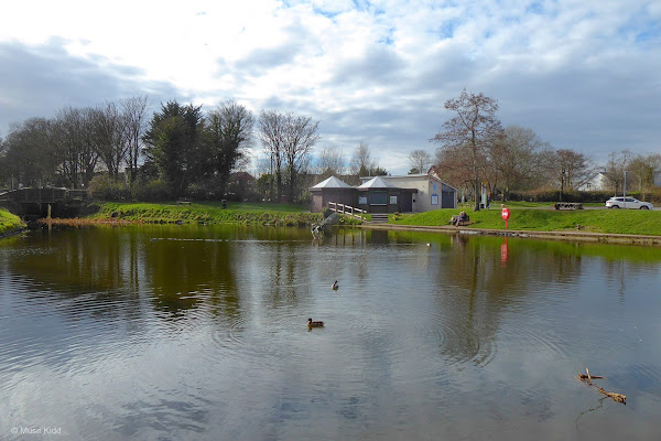
A couple of years back, the Canal & River Trust decided two massive trees along the pond banks needed to be cut down (for unkown reasons?). Whomever thought of this response deserves a special thank you.


It had become quite a nice day. The temperature had warmed and the rain held off as well. I had cycled just under 40 miles, so after my lunch and with one last look over the fence toward Malpas; I thought it time to turn around and head home.

Some folks are quite serious with their landscaping along the canal. There are many formal and elegant presentations. Some folks however, take a much more light-hearted approach to their waterside displays.

This fella has taken the idea of a "whimsical garden" to an entirely different level. (Can you spot Elvis?)


I've not seen algae this colour before (below) and I must say that I found it a little alarming.

Fortunately, that was the only place where I saw red algae and the remainder of the ride along the canal was simply stunning in the late afternoon sun.


Above the village of Risca you get perhaps the best view looking northwest (below). The large hump in the middle of the image seperates the Sirhowy Valley from the Ebbw Valley. You can also make out how this canal route snakes along the right edge hill.
Just before the hump (at Crosskeys), I'll drop down to the valley floor where I will begin cycling north up western side of Sirhowy Valley.
Just before the hump (at Crosskeys), I'll drop down to the valley floor where I will begin cycling north up western side of Sirhowy Valley.


Parc Waunfawr and Sirhowy Park
NCN Route 47 leaves the canal just below Crosskeys where it then crosses the High Street and enters the cute and Green Flag winning Parc Waunfawr
Unfortunately, my poor photos don't really serve the park justice and deserve a better attempt. Also of particular note, Parc Waunfawr sits at the confluence of the Sirhowy and Ebbw rivers.
Unfortunately, my poor photos don't really serve the park justice and deserve a better attempt. Also of particular note, Parc Waunfawr sits at the confluence of the Sirhowy and Ebbw rivers.


The pentultimate section is perhaps my most common route to cycle. It seems to be at the end of most rides and I am very fortunate to have this bit of relaxed cycling before heading through Blackwood and making the final push up the hill to home. This is Sirhowy Parc.


Looking down onto the Sirhowy River from near the park entrance (above). At this time of day, it's hard to photograph, but this is how I often see it and it's lovely.
Summary - Pen-y-Fan Pond & 14 Locks
Essentially, this ride was a combination of all my shorter "go-to" routes. Most every ride I make includes at least one part of the this overall route.
Today it's a frigid 4° and quite windy — too cold for me to venture out on even a short jaunt. It's been six months since I made this ride and as I sit here writing this little report, warmed by the fire, I long for those early spring days again.
We are very fortunate to have so many wonderful cycle routes so near and so easily accessable. Thank you National Cycle Network and Sustrans.
I hope you enjoyed this little write-up and as always, thanks for spending your time with me & Bike Wales.
Cheers! - muse kidd
We are very fortunate to have so many wonderful cycle routes so near and so easily accessable. Thank you National Cycle Network and Sustrans.
I hope you enjoyed this little write-up and as always, thanks for spending your time with me & Bike Wales.
Cheers! - muse kidd
| Ride Name: | Pen-y-Fan & 14 Locks |
| Start Date: | Wed. Mar. 17, 2021 |
| Starts in: | Oakdale, Wales, GB |
| Departed: | 6:55 am |
| Distance: | 53.9 mi / 86.74 km |
| Elevation: | + 2985 / - 2988 |
| Max Grade: | 9.6% |
| Duration: | 08:22:40 |
| Move Time: | 05:09:46 |
| Stop Time: | 03:12:54 |
| Max. Speed: | 31.9 mph |
| Avg. Speed: | 10.4 mph |
| Weather: | clouds, some sun |
| Temp: | 11°c / 52°f |