This report is from a combination of several rides I made up the Ebbw Fach Valley.
I encountered road closures and detours. I missed a couple of things, yet discovered a couple more — and now I've got two projects instead of one!
I encountered road closures and detours. I missed a couple of things, yet discovered a couple more — and now I've got two projects instead of one!

Overview: Blaenavon Ramble [ explore ]
Date: April 10, 2021
Distance: 53.4 miles / 85.94 kilometres
Elevation: +3,325 ft / -3,319 ft
Duration: 10 hours, 23 mins.
Distance: 53.4 miles / 85.94 kilometres
Elevation: +3,325 ft / -3,319 ft
Duration: 10 hours, 23 mins.
The primary goal of this route is utilise and connect well-known cycle paths of the National Cycle Network into a single circular loop. It should be noted, that the first section of this route is very similar to my "Cordell Country" route with the difference being an expanded section leaving out at Blaenavon to climb the back-side of the Blorenge over to the adjacent Usk Valley.
The route travels in a clock-wise direction which can start at either Pontypool/New Inn Train Station or Llanhilleth Train Station. However, I've chosen to start in Pontypool so that I cycle the section to Llanhilleth first — primarily because I think it is the least interesting section and I'd rather see it at the beginning of the ride than at the end.
My layout and route map(s) are a work in progress, so bear with me as I sort out the thorny details. Warning: This is a long read. I'm sure that I'll need to cut back on the number of images for the final version.
Lastly, I've divided the overall route into three sections to make navigation somewhat easier. The sections are bookmarked so that you may jump ahead or return to a specific part.
Note: The map above includes my entire day of cycling from Oakdale through Blaenavon and then back home to Oakdale. The final version will be signifcantly shorter by approximately 18 miles.
PART ONE | Pontypool to Llanhilleth | 8.2 miles
A combination of traffic-free and on-road cycling that follows NCN Route 466 through Pontypool Park and town centre to Hafodyrynys via the Old Crumlin Road. At Swffryd the route turns down a re-purposed train line to a quiet road heading up the Ebbw Valley into Llanhilleth.
PART TWO | Llanhilleth to Blaenavon | 14.1 miles
In Llanhilleth the ride turns north onto NCN Route 465 following quiet lanes, traffic-free paths, and shared-use paths before joining NCN Route 46 outside Brynmawr. From Brynmawr the route follows NCN Route 46 a short distance out of town before joining NCN Route 492 south to Blaenavon.
PART THREE | Blaenavon to Pontypool/New Inn | 12.6 miles
Ride climbs through Blaenavon and over the high ridge before dropping into the Vale of Usk. The route then winds behind Llanover and back onto Old Abergavenny Road at Maerdy. The route continues along Old Abergavenny Road to joins the Monmouth & Brecon Canal (NCN Route 49) to return to start at Pontypool.
SUMMARY | A Look Back and Future Plans
I begin with my thoughts of the day and what I liked or disliked about the ride. I also include my ideas for improvement as well as a Ride Report Card for the day.
PART ONE
| NCN | 49 | 466 | 465 |  |
Pontypool - Llanhilleth |
Distance: 8.2 miles / 13.19 kilometres
Elevation: +428 ft / -482 ft
Elevation: +428 ft / -482 ft
The beginning section which runs from Pontypool/New Inn Train Station to Llanhilleth is a combination of on-road travel and traffic-free cycle paths. The route very briefly joins the Monmouth & Brecon Canal (NCN Route 49), but then for the next 2 miles it snakes it's way through Pontypool Park and the High Street of the town proper.
Leaving town on Old Crumlin Road (NCN Route 466) the ride travels 4.5 miles to just outside Hafodyrynys. The path briefly becomes traffic-free, but then merges back onto the road passing through several housing estates before changing once again to traffic-free heading down into Llanhilleth. The very last part joins the road yet again for the short distance to just outside Llanhilleth Train Station at the Miner's Institute.
Leaving town on Old Crumlin Road (NCN Route 466) the ride travels 4.5 miles to just outside Hafodyrynys. The path briefly becomes traffic-free, but then merges back onto the road passing through several housing estates before changing once again to traffic-free heading down into Llanhilleth. The very last part joins the road yet again for the short distance to just outside Llanhilleth Train Station at the Miner's Institute.
| ▲ Back to |
| ROUTE COLOUR KEY: | Traffic-free | Quiet Road | Shared Use | Steep Hill |
From the Pontypool/New Inn Train Station we begin our journey by making our way .25 mile to the Monmouth & Brecon Canal. The entrance is just before the bridge crosses the canal.

The start of the day was looking rather grey. The temperature was a cool 7°c and it was surprisingly quiet for a Saturday morning.


However inviting the canal looks, we're not on it for long as we exit by the boat docks and snake our way down a short lane to the entrance of Pontypool Park.
Pontypool Park itself has an interesting history as it was private estate of the Hanbury family for nearly 250 years. You can read about the park and the "Sally Gates" as well.
Pontypool Park itself has an interesting history as it was private estate of the Hanbury family for nearly 250 years. You can read about the park and the "Sally Gates" as well.


Note: I need a description of the ride through town along with a few photos of Pontypool High Street. It's a short distance but kinda tricky and the route is not sign-posted at all.

Once through town the ride begins in earnest along Old Crumlin Road. There are a few mild climbs, but the road is generally very quiet. (I don't recall if this section is sign-posted? However, this is NCN Route 466 and occasionaly there are cyclists painted on the tarmac.)
Note: NCN Route 466 is actually broken into two parts; the section we're riding runs east to west between Pontypool and Llanhilleth, while the second section runs south to north from just above Llanhilleth at Aberbeeg to Ebbw Vale. The description on the Sustrans website is poorly written and doesn't explain the route(s) and their differences clearly.

The old coal washery is about the only building you'll pass along this section and it's certainly the most unusual. There is a short description of the Hafodyrynys colliery with some additional information about the washery itself here: Read more....
After 2.7 miles Old Crumlin Road ends at a very busy (and dangerous!) road crossing over the A472. Once on the other side the route becomes traffic-free for just over a mile before rejoining the road.
After 2.7 miles Old Crumlin Road ends at a very busy (and dangerous!) road crossing over the A472. Once on the other side the route becomes traffic-free for just over a mile before rejoining the road.


We cross the A472 one more time (with a traffic light!) and leave the busy-ness of all that traffic behind as we as we cycle through sleepy Hafodyrynys and into Swffryd. The sun is starting to come out and the morning is warming up nicely too.


Looking out across the Ebbw Valley toward Crumlin; the photo above captures my idea of "The Valleys" perfectly. Below, leaving Swffryd we move onto a short section of re-purposed train line which leads down to Llanhilleth. (I love the old railroad bits left behind.)


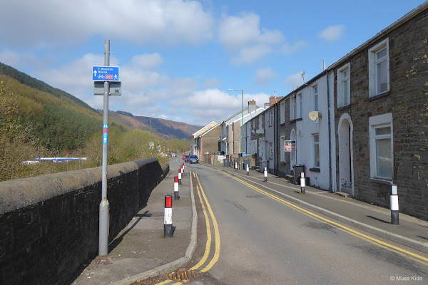
NCN Route 466 ends at a cul-de-sac in Llanhilleth. Here we join NCN Route 465 to continue up the road past a very sleepy row of houses.


The valley is quite narrow through here and the road weaves and climbs for just over a mile before dropping steeply into the village proper.


Just ahead is Llanhilleth Train Station, but we need to take a sharp left turn and head over the bridge. We'll end Part One of our ride by the Miner's Institute where there are public toilets and a small cafe (limited hours). Additionally, There are several small shops around the village for snacks or drinks. By the way, can you spot the NCN Route 465 route sticker on the pole to the right?
PART TWO
| NCN | 465 | 46 | 492 | |
Llanhilleth - Blaenavon |
Distance: 14.1 miles / 22.69 kilometres
Elevation: 1,165 ft / -581 ft
Elevation: 1,165 ft / -581 ft
The second section of our ride today is the longest and most diverse. First, we will continue our ride along NCN Route 465 with a slow and steady climb up the Ebbw Fach Valley. We'll pass through the small villages and towns of Aberbeeg, Six Bells (including a short visit to the Guardian!), Abertillery, Blaina, and Nantyglo — as we make our way north to the Heads of the Valley. Out next stop will be at the town of Brynmawr.
From Brynmawr, we will briefly join NCN Route 46 as we head east across the high ridge toward the Blorenge where we'll split off to join NCN Route 492. This route will first lead out us across the vast open plateau above the Afon Llwyd Valley before turning south and dropping dramatically through the scenic Garn Lakes and into the town of Blaenavon.
From Brynmawr, we will briefly join NCN Route 46 as we head east across the high ridge toward the Blorenge where we'll split off to join NCN Route 492. This route will first lead out us across the vast open plateau above the Afon Llwyd Valley before turning south and dropping dramatically through the scenic Garn Lakes and into the town of Blaenavon.
| ▲ Back to |
| ROUTE COLOUR KEY: | Traffic-free | Quiet Road | Shared Use | Steep Hill |
Part Two begins by turning north through the housing estate in Llanhilleth on NCN Route 465. Our ride alternates between quiet lanes and traffic-free paths as we weave our way for 3 miles through several parks and the villages of Aberbeeg, Six Bells, and Abertillery.

I think it's important to take your time and look at your surroundings... sometimes you'll be surprised at the view. This is a pretty unusal perspective (below).


The route takes you right down along side the Ebbw Fach river in Aberbeeg. The houses through here haven't been rendered and still retain their original stone exteriors. The gardens too are super cute.


Leaving Aberbeeg the route climbs onto the old rail line and heads into the woods. The old passenger platform seems long forgotten.

NCN Route 465 shares much of the same path as that of the Ebbw Fach Trail. It's a shame that Sustrans Cymru and the Blaenau Gwent County Borough Council didn't work together on this, because essentially we have two groups producing two unique sets of signs, promotional materials, and websites all for one route.


At Parc Arael Griffin we reach a highlight of this route; The Guardian. This monumental sculpture was erected to commemorate 45 men and boys who lost their lives in 1960 from an underground explosion at the Six Bells colliery which once stood here.


It's worthwhile to take the very short detour off the main route to see this magnificient sculpture up close and appreciate it's significance. The information boards around the park offer great insight into it's importance and explain the impact felt by the community following this tragic event.


It's powerful stuff.


But we must move on... continuing up the path, we next enter the town of Abertillery. Here the route leaves the woods and re-enters the road as we snake through the Tesco car park and into the housing estate back along the river.

From the housing estate we enter Abertillery Town Park. Although some imporvements have been made over the past few years, the park itself is rather desolate and I've rarely seen more than a few people at a time whilst cycling through.

It's actually rather sad because the park has an extensive history and was very popular having sporting fields, a band stand, and at one point even a cycle track for local racing of which the remnants can still be seen. Read more... (Insert photos of Abertillary cycle track.)

As we leave the park and enter the woods, the route narrows. For the next mile we closely follow the river, even crossing it a couple of times before reaching the village of Blaina.


There's a picturesque little bridge straddling the river banks where herons can often be seen carefully stepping at the water's edge as it seems a popular spot for them to fish.


I took my first detour as I left the woods by the small car park. Heading off to my left is a narrow road that I felt compelled to explore... just a bit.


After a short distance I could tell that I was simply heading back toward Abertillery on the opposite side of the river. It's an interesting route and one I might choose if the lower path through the woods is muddy... as is often the case being so closely situated to the river.

Today, it was just a short explore and I turned around to continue along my planned route.

And the day was beginning to look spectacular.


Just below Blaina the route enters a small service road for the town park and then passes under the very busy A467. I find that there's something quite charming about the contrast of the playground equipment to the barren hillside in the background.

Next we've a nastly little underpass that is often be littered with shards of broken glass. (I would recommend walking your bike through...) Unfortunately, this is a common attribute with most all of these under passes you so often see in the Southeast Valleys.
Originally built with a sense of pride, these convenient little subways can be found throughout the Valleys. When many of the new bypass roads were built, these underpasses provided communities safe access to adjoining parks or greenspaces. The tunnels were often decorated with tiled mosaics depicting features of the community, but now most have fallen into disrepair and disgrace — victims of pointless youthful aggression, empty meaningless graffiti, and a council budget stretched thin.
Originally built with a sense of pride, these convenient little subways can be found throughout the Valleys. When many of the new bypass roads were built, these underpasses provided communities safe access to adjoining parks or greenspaces. The tunnels were often decorated with tiled mosaics depicting features of the community, but now most have fallen into disrepair and disgrace — victims of pointless youthful aggression, empty meaningless graffiti, and a council budget stretched thin.

But I digress. Let's move on as our route now saddles alongside the very busy A467. From here we've got two miles of uninteresting shared-use pathway to pedal before reaching the village of Nantyglo.

Here at my desk, looking back at my photos of the dull cycle path, I'm thinking; "next time I'm going through the villages..."
No drones were used in the taking of the photograph shown below. I'm simply on the footbridge crossing the A467, looking south back toward Blaina.
No drones were used in the taking of the photograph shown below. I'm simply on the footbridge crossing the A467, looking south back toward Blaina.


Always on the lookout for a pretty girl, I spotted this gal far off on the crest of the hill as I was entering Nantyglo.

And just like pretty girls know when you're looking at them, she puts on a pose for the camera... but in my still-young heart, I'm hoping it's for me. What a looker.

I stopped to see the Roundhouses outside Nantyglo, but these fascinating structures are privately owned and the folks working about didn't seem too keen on me poking my nose around. I only took one quick photo, but these too have an interesting history and are well-worth another visit. Read more...

So with a nod and smile, I moved on down the path.

You could probably throw a rock across the width of Nantyglo and hit someone standing in Brynmawr... they're right up against each other, blink and you'd miss them both.


NCN Route 465 comes to an end at Brynmawr. Here we turn right onto NCN Route 46 and head east into town. (I think it's time for a short break...)
This area is unofficially called the Heads of the Valley, mostly becausue of the A465 that runs from Swansea and on into England.
Brynmawr is also known for being the coldest spot in the Valleys and it certainly feels like it today. The temperature on my Garmin reads 4°c and the wind is howling. It was difficult to sit and have coffee, but it's a good spot by the town square and there's not much after this until we get down to Blaenavon.

Note: Insert more photos of Brynmawr, especially; the Market Hall Cinema.

Coffee and snacks consummed, it's time to head off again. Leaving the windy square, the route passes through one more small housing estate before winding its way toward the high ridge looming on the outskirts of town.
They've been working on the Heads of the Valley Road for over 10 years and they have completely transformed the surrounding landscape. What was once a fertile green hillside now appears like the surface of a strange and distant planet. Read more...
They've been working on the Heads of the Valley Road for over 10 years and they have completely transformed the surrounding landscape. What was once a fertile green hillside now appears like the surface of a strange and distant planet. Read more...

However, NCN Route 46 soon opens up as it heads out acoss the high ridge above Clydach Gorge. To our left, the Heads of the Valley Road is hidden deep along the valley floor.
In the distance you can see the Blorenge (centre, highlighted by the sun), and the farthest mountain peaking into the clouds is the Sugarloaf. Of particular interest is that we are slowly approaching the highest elevation of our ride.
In the distance you can see the Blorenge (centre, highlighted by the sun), and the farthest mountain peaking into the clouds is the Sugarloaf. Of particular interest is that we are slowly approaching the highest elevation of our ride.

Way up here, seemingly-like the middle of nowhere, we merge onto NCN Route 492 and continue our climb further up the ridge. Whilst to our left, NCN Route 46 drops down dramatically into Clydach Gorge making it's way east toward Abergavenny.


Yes, I'm talkin' to you.

Windswept and leaning left, the landscape appears shaped by the sky.

Then after crossing the busy Blaen-Afon Road (B4248) we're at the highest point of our journey; 1,413 ft. above sea level. Not terribly difficult, but we've climbed over 1,150 feet in just under 12 miles.

And then we get this...

High up on this desolate plateau — it's big sky country and it reminds me of Montana. I've heard some cyclists complain about the path being unpaved but, I think it's perfect.

This is awesome cycling country.

Looking down the valley toward civilisation; Garn Lakes lies just ahead, then Big Pit and Blaenavon, Pontypool, and everything else all the way to Newport.


Who were the people that built this house? Why did they choose to live in such a desolate place? Where have they now gone? What is their story?
A dog barks at me lasily. "Howdy pup. Good day to you."
Looking down at the railline, I suppose this might be more interesting to photograph on the weekend when the old-restored steam locomotive has stopped here. There is always such excitement when families are out with their children — laughing and running about on their day out. But then, this what you see up here most of the time. This is the Valleys, lonely, largely forgotten... waiting.


It's hard to envision this area as once a massive coal mining complex, but Garn Lakes Nature Reserve is another wonderful example of how Wales is working to regenerate it's dark and dirty industrial past into a lovely green future.


Then too quickly it seems, I am down the hill, past the lakes and the nature reserve, down the path to the end of Part Two of my adventure.

Were I to continue straight on; NCN Route 492 heads down to Pontypool and Cwmbran. Were I to turn right; I'd head up to Big Pit National Coal Museum where I could spend a day (or more) exploring the history of coal mining in the Southeast Valleys.
But today, we're going to turn left and head into the town of Blaenavon... the heart of this industrial landscape inscribed by UNESCO in 2000 as a World Heritage Site.
But today, we're going to turn left and head into the town of Blaenavon... the heart of this industrial landscape inscribed by UNESCO in 2000 as a World Heritage Site.
PART THREE
ON ROAD |
+ | NCN | 49 | |
Blaenavon - Pontypool |
Distance: 12.6 miles / 20.27 kilometres
Elevation: +868 ft / -1,550 ft
Elevation: +868 ft / -1,550 ft
The third part begins by entering Blaenavon and winding our way through the town centre. After leaving the High Street, we'll slowly climb through out of town passing through several housing estates before entering the countryside again.
Once outside of town, the route continues to climb along the south-western edge of Mynydd Garnclochdy ridge before dropping dramatically into the Vale of Usk just outside Llanover.
Crossing the A4042, our route winds behind Llanover before joining Abergavenny Road. The route finally climbs onto the Monmouthshire & Brecon Canal (NCN Route 49) at Croes-y-Pant for the remaining trek back to Pontymoile Boat Basin.
| ▲ Back to |
| ROUTE COLOUR KEY: | Traffic-free | Quiet Road | Shared Use | Steep Hill |
For those unfamiliar with this part of Wales, you can (and should!) spend an enormous amount of time exploring the many interesting features of the Blaenavon World Heritage Site. The Blaenavon Ironworks shown below is just one part of the massive industrial complex that deserves it's own feature. But for us... we've got to keep pedaling.

We start by heading up the quaint High Street passing an assortment of enticing local shops. Regardless of which road you choose, nothing can be done about the hill... it's just a steep climb out of town.


Fortunately, the incline levels off somewhat as we leave the last set of houses. This is the Mynydd Garnclochdy ridge and we've just a little more climbing ahead of us.


Along the way, we come across this mysterious place beside the road. I've been told several differing tales; some say it is where a WWII plane crashed, while others say it is where a young boys' body was found after he had been lost wandering on the hill.
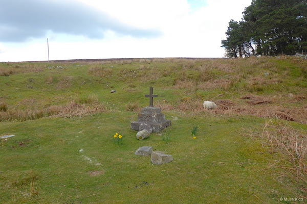
There is a small marker, but it hasn't any inscription on the stone. What does this place signify? Why is it here? I've searched the Internet and found nothing.

There is a bench under the tree... ribbons, flowers, and photographs adorn its trunk commemorating recently lost loved ones. However, they don't seem connected to the marker over in the field? It is all very solomn yet, odd. If you know something more, drop me a line.


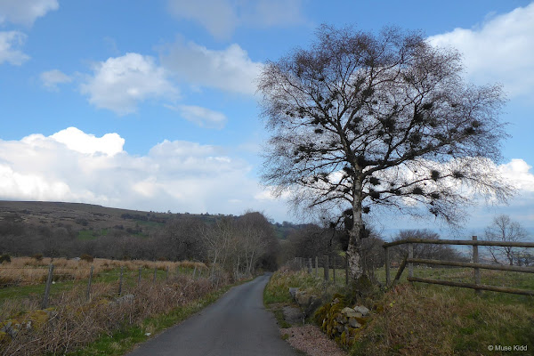
So I carry on. The day is lovely. The clouds are racing past and the light changes from sun to shadow and back to sun before I can get my camera focused.


There is no one about... no cars pass, no walkers wave hello. It's just me and the wind whispering across this stunning landscape.

Than I came to a fork in the road where I had planned to turn right, but there is now a gate blocking my path with a "No Access" sign. It appears to be closed for logging. Oh well, this changes my plans as I begin detour number 2.
I haven't been down this road before, but I'm not one to shy away from exploring. (Btw, that's a lot of squirrel's nests in that tree!)
The start of the decent wasn't terribly long, but it was very, very steep.
The start of the decent wasn't terribly long, but it was very, very steep.


As the road leveled off, I had a much needed respite... long enough to appreciate this lovely farm. Anyone have a clue what the conical building is used for?
Note: Upon my return while putting this report together, I discovered that you can stay at this lovely farm... check it out: Hill Farm AirBnB.


And the views are stunning. It was at this point that I realised I was across the valley from the road I had planned to ride. (And I think one of those white buildings far off on the opposite hillside might be the famous Goose & Cuckoo Pub?)


I also realised that I much prefer this side of the valley. Yes, the road is incredibly steep in places, but it's worth stopping every now and again to get off your bike, climb one of the nearby stiles and just look... the views speak for themselves.


And then the road leveled off again by yet another farm tucked into the hillside.

This time however, I was provided with views up the valley to my left. Looking north past the remnants of some long forgotten architecture; the Skirrid proudly stands on the horizon.


Whilst witing this report I stumbled across this little cottage (shown below) as it is listed on the Llanover Estate website... Yup, I'd like to see inside this one, please. View lisitng...

With one last drop I was down by the very busy A4042 in Llanover. It's a shocking change from the narrow lanes and leafy canopy I've had coming down the mountain. I'll cross the road and head into the countryside as I snake my way behind the impressively large Llanover Estate.


From what I can gather from reading on the Internet and referencing online maps, all of the land to my right is part of the Llanover Estate. It is roughly 27 acres in size.


The estate maintains a flock of Welsh Black Mountain sheep. The bloodline dates back to the early 1800's when pedigree stock was brought here from West Wales. Read more...


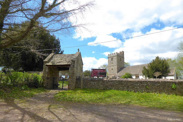
Squeezed between the River Usk and the rolling pastures of Llanover Estate, St Bartholomew church contains the elaborate grave of Benjamin Hall, 1st Baron Llanover and his wife, Augusta Hall, Baroness Llanover.
Benjamin Hall oversaw the rebuilding of the Houses of Parliament in 1859, including installation of the 15-ton bell in the clock tower. The Baron was quite a tall man and many attribute the clock's name; "Big Ben" to him. Lady Llanover was quite a character. Along with being a fervent supporter of the temperance movement, she is credited with revitalising the Welsh language as well as creating the "so-called" traditional Welsh costume.
Benjamin Hall oversaw the rebuilding of the Houses of Parliament in 1859, including installation of the 15-ton bell in the clock tower. The Baron was quite a tall man and many attribute the clock's name; "Big Ben" to him. Lady Llanover was quite a character. Along with being a fervent supporter of the temperance movement, she is credited with revitalising the Welsh language as well as creating the "so-called" traditional Welsh costume.
Llanover Estate owned cottages can be spotted thoughout the area by their distinctive bright white with grey trim paint schemes. Tidy!


The sun has come out and the afternoon is a delight. The day looks and feels so different than when we were high up above Garn Lakes just a couple of hours ago.

About a mile up the road, we turn right onto Abergavenny Road and head up toward Llanover House itself. Behind the rough stone wall at the edge of the lane you can see a second wall, much taller and made of brick... that is their vegetable garden. Peasants KEEP OUT!

A short distance up the lane you can peek over the smaller stone wall to see into the famous Llanover Gardens. Check out this stunning video footage of Llanover Gardens.


Continuing up Old Abergavenny Road, I soon crossed the A4042 (again) and then passed over the Monmouth & Brecon Canal (again) and it's the perfect time and place to stop for lunch.

Burried deep beneath a thick canopy of trees, the sunlight can hardly get through to the lush canal below. Check out the Swiss Family Robinson style walkway on the left. That leads to a cool gazebo-like treehouse!


With lunch in my belly, it's time for a leisurely ride up the road. The afternoon sun has warmed up the day nicely and I can relax whilst cycling along at an easy-peazy pace.


The road turns slightly to cross over the canal again, so I make my way down onto the towpath. I'm feeling completely lathargic and with six miles to reach Pontymoile Basin, I decide that it's time to just glide along and enjoy the views.


And just look at the views...


The only sounds are of my tyres sofly crunching over the fine gravel and the water gently lapping at the sides of the canal boat.


Everything feels lazy as I drift into Goytre Wharf. Slower than a slow cyclist, a small boat gurgles along to the hum of it's electric engine.
Goytre Wharf hosts a number of activities, from longboat hire, canoe hire, fishing, and yes, you can even rent a bike! Across the canal there's a lovely cafe with public toilets and plenty of picnic tables scattered throughout the area.
The canal dates back to the early 1700's, whilst the wharf and adjoining restored lime kilns are over 250 years old. Read more...
The canal dates back to the early 1700's, whilst the wharf and adjoining restored lime kilns are over 250 years old. Read more...

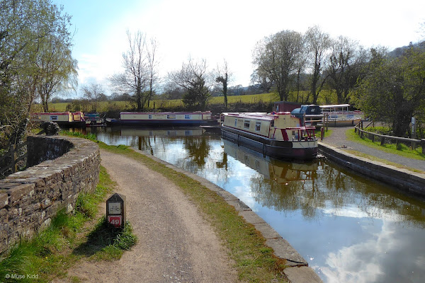
The canal path is also NCN Route 49 which runs all the way from Newport in the south to Brecon in the north. Some parts are a bit hilly as you come up through the locks below Pontymoile and a few sections can be muddy, north of Llanfoist, but overall, it's a brilliant cycle route for all ages and every skill level. It is simply a "must ride" for every cyclist.

I have photographed this section of the canal more than any other place I've cycled in Wales. It's just so lovely and to be fair it's impossible to take a bad photo.


Hello little one...


I just happened to be here at the right time of day to catch the shadows from the fences aligning perfectly with the paths (above) and high on the hill to my right, Pontypool Folly stands silouetted in the late afternoon sun (below).


It's been a glorious day and I've only a short distance now to reach Pontymoile Basin.


And there we have it. We're back to Pontymoile Basin. Our ride is complete!
Summary: A Look Back and Future Plans
Blaenavon Ramble [ explore ] - I developed this route from a couple of different rides that I thought I would link together nicely. Working from my Cordell Country route, I wanted something a bit longer which would include some cycling in the Vale of Usk.
Most of the images I shot from the ride I made in April, however I supplemented the set with a few I from previous rides. When I repurpose this into my Routes to Ride section, I'll cut down on the total number of images, but for now I wanted to see everything together.
Most of the images I shot from the ride I made in April, however I supplemented the set with a few I from previous rides. When I repurpose this into my Routes to Ride section, I'll cut down on the total number of images, but for now I wanted to see everything together.
Note: The map above includes my entire day of cycling from Oakdale through Blaenavon and then back home to Oakdale. The final version will be signifcantly shorter by approximately 18 miles.
This ride included a couple of detours, the last of which I plan to keep for my Routes to Ride section. I really enjoyed cycling down the northern side of the valley to Llanover. I'll include the sidebars regarding the Blaenavon World Heritage Site, as well as the train station and weather details. I foresee these as elements which can be shared across multiple routes.
An interesting figure to note about this ride is that my stopped time was almost as long as my moving time.
Overall it was a good day out and this method of compiling several rides into a longer route is an interesting process. I've got several additional ideas floating in the back of my mind. Meanwhile, look for a condensed version of this route to be added to my Routes to Ride section soon.
I hope you enjoyed this little write-up and as always, thanks for spending your time with me & Bike Wales.
Cheers! - muse kidd
| Ride Name: | Blaenavon Ramble [ex] |
| Start Date: | Sat. Apr. 10, 2021 |
| Starts in: | Oakdale, Wales, GB |
| Departed: | 9:03 am |
| Distance: | 53.4 mi / 85.94 km |
| Elevation: | + 3325 / - 3319 ft |
| Max Grade: | 8.9% |
| Duration: | 10:23:25 |
| Move Time: | 05:45:02 |
| Stop Time: | 04:38:23 |
| Max. Speed: | 30.5 mph |
| Avg. Speed: | 9.3 mph |
| Weather: | sun, some clouds |
| Temp: | 9°c / 48°f |