Just by chance, I discovered that a new walking and cycling route had opened between Tintern and Chepstow. The most exciting aspect of this discovery is that part of the new route makes use of a re-purposed train tunnel!

Overview: Wye Valley Greenway [ explore ]
Date: June 16, 2021
Distance: 104.8 miles / 168.66 kilometres
Elevation: 168.66
Duration: 14 hours, 11 mins.
Distance: 104.8 miles / 168.66 kilometres
Elevation: 168.66
Duration: 14 hours, 11 mins.
Repurposing disused train tunnels for walking and cycling is starting to become a thing here in the UK. The first big tunnel opening happened back in 2013 and actually involved two tunnels; Bath Two Tunnels. The opening festival was extremely popular with well over a thousand cyclists showing up and created one of the most unique cycling events I have ever experienced.
However, Wye Valley Greenway opened to the public on 01 April, 2021 with little fanfare. I like to think that I keep on top of cycle routes and their development, but this one came as quite a surprise. However, as soon as I read about it — I had to go see it for myself.
Along with offering cyclists a 1080 meter ride through Tidenham Tunnel, this new route would also offer cyclists an alternatative to the long slow slog up from Tintern to St. Arvan's along the very busy A466 as well as avoiding the remainder of the road into Chepstow.
I've cycled this overall route numerous times, but exploring the Wye Valley Greenway and cycling through the Tidenham Tunnel was the premise of my journey.
Note: The map above includes my entire day of cycling from Oakdale to Monmouth, Chepstow and back. The map shown below is just the Wye Valley Greenway.
PART ONE | Oakdale to Tintern | 53.3 miles
A great cycle route through the Vale of Usk then down through the Wye Valley, including some notes, some photos, with the premise of getting to Tintern.
PART TWO | Wye Valley Greenway | 5.5 miles
4.2 miles from Tintern to Tidenham along the greenway, the core of this report. Then a short 1.3 miles from Tidenham into Chepstow.
PART THREE | Chepstow to Oakdale | 45.4 miles
Again, this follows my favourite ride back, mostly along NCN Route 4 to Newport, then NCN Route 47 back up the Crumlin Arm of the Monmouthsire & Brecon Canal.
SUMMARY | A Look Back and Future Plans
What works and what I'll do differently on my next version of this ride. And then what route will I use to get back to Newport for Part Three?
PART ONE
ON ROAD |
+ | NCN | 49 |  |
Oakdale to Tintern |
Distance: 53.3 miles / 85.77 kilometres
Elevation: +2717 ft / -3426 ft
Elevation: +2717 ft / -3426 ft
This first section is one of my overall favourite routes. In fact, if you look at the list of All My Solitaires, you'll quickly notice that my "Monmouth & Chepstow Classic" is the route I cycle most often which is 100 miles or more.
| ▲ Back to |

And of course, I cannot help myself from taking snaps along the Monmouthshire & Brecon Canal (NCN Route 49). I'm only on this route from Pontymoile Basin to Goytre, but those five miles are usually stunning.
At Goytre I leave the canal and begin cycling out into the Vale of Usk. This countryside too offers an unlimited amount of photographic attention, but I try to limit myself to those I find the most demanding.
At Goytre I leave the canal and begin cycling out into the Vale of Usk. This countryside too offers an unlimited amount of photographic attention, but I try to limit myself to those I find the most demanding.


There are few places where you can cross the River Usk. In fact, there are only about 14-15 bridges. And yes, this is another one of my many goals; to cycle, photograph, and document the bridges that cross the River Usk. Too many projects, not enough time!


But this countryside is too demanding! And especially on a summer day such as this. Urgh! Too much beauty!

So I race like the wind... stop, take a photo, race again.

It's roughly 35 miles to Monmouth, from there another 15 down to Tintern. I want to focus my attentions on the Wye Valley Greenway - which is just 4.2 miles long. Once that is done, I'll then have another 50 miles to get back home.

I stopped briefly in Monmouth to snap a photo of my bike beneath the statue of Charles Rolls. There's a connection here with Mr. Rolls, the Wright Brothers, and myself — from North Carolina (which deserves a sidebar at somepoint.)

Heading down the Wye Valley, I soon enter England and find myself standing along the side of the road again. Thankfully the summer days are long, but I'm feeling anxious. It's just past noon and I'm already chasing daylight.


I had cycled 45 miles by the time I reached Redhook and needed to eat. There's a perfect spot in the little town park which sits right along the banks of the Wye River.


But I cannot dawdle. I give myself 30 minutes and I'm back on the road with every intention of not stopping again until I reach Tintern...

but on a day like this I cannot help myself. It's just spectacular.


As I stand on the bridge leading back into Wales, cars pass, blank faces staring, emotionless, and I think how fortunate I am to be here on my bicycle, out in the summer air and sunshine.


I stick to my resolve and cycle through the quaint village of Llandogo without stopping. It's a lovely area deserving attention, but soon I am coming into the village of Tintern where the Wye Valley Greenway begins.


Tintern and the famous Tintern Abbey is quite a hive of activity, especially on a fine day. There are several interesting places to stop for coffee and cake, but I only pause to take a few snaps (as tempting as a coffee sounds). I must find the entrance to this new cycle path!

PART TWO
GREENWAY |
+ | ON ROAD |
Wye Valley Greenway |
Distance: 4.2 (on greenway) + 1.7 (on road) = 5.9 miles / 9.49 kilometres
Elevation: +372 ft / -382 ft
Elevation: +372 ft / -382 ft
It took a few minutes to find the entrance to the greenway. I asked a group of walkers coming off the bridge who pointed me in a different direction. But when I returned to the main square and asked at a cafe, they sent me right back to this bridge! (Yup, the walkers had said bicycles were not allowed on the path!)
There on the right side of the bridge is a small sign for the route. (The walkers had been standing directly in front of it. Urgh!) Hardly a noteworthy beginning and not the most obvious entrance to something so significant. I would have thought that there might be something more pronounced and then too, maybe some type of sign along the main road?
There on the right side of the bridge is a small sign for the route. (The walkers had been standing directly in front of it. Urgh!) Hardly a noteworthy beginning and not the most obvious entrance to something so significant. I would have thought that there might be something more pronounced and then too, maybe some type of sign along the main road?
| ▲ Back to |

| ROUTE COLOUR KEY: | Traffic-free | Quiet Road | Shared Use | Steep Hill |
Before we continue, a major feature of the route is the Tidenham Tunnel. It's crucial to understand the opening times and dates of the tunnel before you make your journey. (You can still make the trip when the tunnel is closed, but it involves a 3.5 mile diversion!) To find the details of the tunnel hours of operation and latest updates be sure to: ► Visit the Wye Valley Greenway website.
Also, whilst doing research on the Greenway, I ran across this document that details the planned construction of the path which you may find of interest. ► Read more
Also, whilst doing research on the Greenway, I ran across this document that details the planned construction of the path which you may find of interest. ► Read more


A couple of quick snaps looking upstream toward the village and then downstream toward the abbey (you can see the abbey peeking out from behind the trees.) Then on the other side of the bridge, the path heads directly into the woods.


The greenway certainly earns its name — the thick canopy of the trees is fabulous. It starts out rather rough and can get quite narrow in places (I was definately pushing the limits of my 32c width tyres and several mountain-bikers passed me with little notice.)
However, slow is the way to go and pausing to look through the brush to your right offers wonderful glimpses of Tintern Abbey on the opposite side of the river.
However, slow is the way to go and pausing to look through the brush to your right offers wonderful glimpses of Tintern Abbey on the opposite side of the river.


1.7 miles down the path you reach an important junction; the tunnel diversion. As I mentioned earlier, it's crucial to understand the opening times and dates of the tunnel before you make your journey. To find the details and latest updates be sure to: ► Visit the Wye Valley Greenway website.


I plan to take the diversion on my next trip — so that I can fully evaluate the difficulty, but from looking at the route profile (shown below), the begining section along the forestry road is at an 11.5% grade in places! Plus, it takes you 3.5 miles out of the way and completely defeats the purpose of the Greenway for a cyclist.
| ROUTE COLOUR KEY: | Traffic-free | Quiet Road | Shared Use | Steep Hill |
However, today I continued straight ahead and much to my delight, the path surface improved significantly. I could cycle all day on crushed stone.


I would guess all the old railway detritus will be eventually removed, but I love it. I think over time they'd become even more interesting as they are overtaken by the undergrowth.


And using the old sleepers for a retaining wall is a great re-purposing of materials and it adds wonderful character to the path.


Tidenham Tunnel
Then roughly .85 mile (1380m) from the diversion we reach the northern entrance to the tunnel itself, and the highlight of my exploration.
Tidenham Tunnel was built as part of the original Wye Valley Railway line running between Chepstow and Monmouth. The rail line opened to traffic on November 1st, 1876 and closed to commercial traffic in January of 1964. However, the southern part of the line, (including the tunnel) remained in use as a private siding for the nearby Tintern and Dayhouse quarries. The last train to pass through the tunnel was in 1981.
The tunnel is 100m below the surface at its deepest point and features low-level lighting to specifically protect the Lesser Horseshoe Bats which roost in the tunnel.
At the time of it's re-opening in 2021, Tidenham Tunnel is the second longest tunnel in the UK's cycle network with a length of 1,188 metres (nearly .75 of a mile).

Before we continue, take a few moments to watch this video provided by Forgotten Relics which highlights how the tunnel was restored by local contractors and over 70 volunteers who worked over 300 days. Many of the volunteers camped out around the site as they erected fences, installed lighting and built bespoke bat shelters.

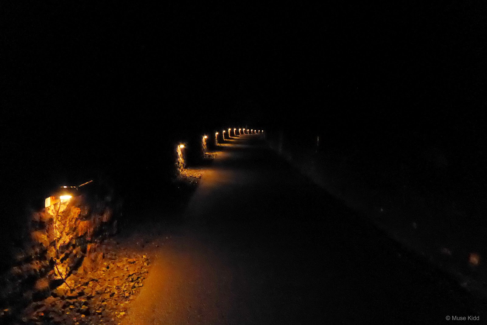
Entering the tunnel is pretty exciting. It's suprisingly dark despite the lights along the side and it's much more narrow than I was expecting.

However, the real surprise was the temperature change... it got quite chilly within a hundred feet of the entrance. Then by the time I had cycled for roughly 5 mins the temperature on my Garmin registered 4°c!
Lights of any sort are not allowed in the tunnel and cyclists or walkers coming from the opposite direction are nearly impossible to see. Be forewarned, it can be quite startling. (Photo above illuminated with a torch, photo below as it actually appears.)
Lights of any sort are not allowed in the tunnel and cyclists or walkers coming from the opposite direction are nearly impossible to see. Be forewarned, it can be quite startling. (Photo above illuminated with a torch, photo below as it actually appears.)

It takes about 10 minutes to cycle the 1,080 metre tunnel and it's a great experience. Riding down from Tintern was well worth the effort.
On the day that I rode the path, the outside temperature was around 21°c and I was just wearing shorts and a t-shirt. By the time I reached the far end of the tunnel, I was freezing. So be prepared!
On the day that I rode the path, the outside temperature was around 21°c and I was just wearing shorts and a t-shirt. By the time I reached the far end of the tunnel, I was freezing. So be prepared!

If you'd like to read more about this fascinating project, be sure to check out: The Forest of Dean & Wye Valley Tourism website.

Looking back at the southern entrance before continuing.


The restoration and repair of this disused bridge makes a lovely decorative feature. Then surprisingly, the route passes through the National Diving & Activity Centre grounds.


After leaving the diving centre, the route enters a high wide plateau which provides a surprsing view across to the River Severn and estuary. Then sadly, the traffic-free section ends at Sedbury Lane.
This part of the Greenway is 4.2 miles long and it took me about 2 hours to cycle with lots of stops to photograph and explore. Some may think that's an awful long time for such a short distance, but personally, I find this perfectly reasonable for a casual ride where you take your time to look and enjoy what's around you.
This part of the Greenway is 4.2 miles long and it took me about 2 hours to cycle with lots of stops to photograph and explore. Some may think that's an awful long time for such a short distance, but personally, I find this perfectly reasonable for a casual ride where you take your time to look and enjoy what's around you.

The traffic-free section ends briefly as you re-enter the roadway at Sedbury Lane.


Sedbury Lane is very quiet and rolls along. There are a couple of turns which are all well-marked; some are a bit unusual, as you can see below.

And then surprisingly, when you leave Sedbury Lane and begin to snake behind Wyedean School, the path becomes traffic-free again!


Once you exit the path at Wyedean School the route enters the roadway for a short distance. (I didn't bother to photograph this section because the road passes through an unremarkable housing estate.)
However, just before dropping down to the Wye River at Chepstow, the path enters an unusual walled section. It's mostly downhill and you need to show caution because there are pedestrians as well as a set of stairs, but the path is very cool.
However, just before dropping down to the Wye River at Chepstow, the path enters an unusual walled section. It's mostly downhill and you need to show caution because there are pedestrians as well as a set of stairs, but the path is very cool.


Then once at the bottom of the hill, the walled path plops you out by The Old Wye Bridge crossing the river and the border between England and Wales.

PART THREE
ON ROAD |
+ | NCN | 4 | | Chepstow to Oakdale |
Distance: 45.4 miles / 73.06 kilometres
Elevation: +2145 ft / -1433 ft
Elevation: +2145 ft / -1433 ft
I've cycled from Chepstow back to Oakdale numerous times and didn't bother to take many photos. Plus, I was tired, it was late in the day, and I had a long way to go yet.
NCN Route 4 from Chepstow back to Newport is a brilliant on-road cycle route. It starts off rolling with some moderate descents and a few solid climbs, but then levels off (literally) as you come out onto the Gwent Levels just past Caldicot.
I tried to find a different way out of Chepstow that avoided two very difficult hills along the A466. But without looking at a map and relying solely upon my vague notions, I ended up just cycling back to the section I had wanted to avoid and added an additional two miles to the ride before leaving town.
| ▲ Back to |

I stopped on the bridge and took a few last photos, but the lighting wasn't great. Chepstow really deserves a dedicated visit, not just a few snaps at the end of long ride.


Chepstow Castle (above) looking mysterious along the cliffs overlooking the River Wye.
Summary: A Look Back and Future Plans
Wye Valley Greenway [ explore ] - I enjoyed cycling the Greenway, but it's rather inconsistent. Some parts of it are excellent whilst some parts are rather difficult.
Overall, I completely underestimated the Greenway and I spent an enormous amount of time documenting the various aspects of the route. I need to go back.
Overall, I completely underestimated the Greenway and I spent an enormous amount of time documenting the various aspects of the route. I need to go back.
Note: The map above includes my entire day of cycling from Oakdale to Monmouth, Chepstow and back. The map shown below is just the Wye Valley Greenway.
My first thought on cycling the Greenway again is to start in Chepstow and head north to Tintern. I think most people approach the route this way and I'm sure it will seem very different. Then additionally, I may return via the diversion to see what that's like.
I also want to spend more time researching the various campgrounds and bike rentals along the way. Plus, I want to find a better way into Chepstow itself.
I was surprised by the route and now that I have a better understanding, I'm looking forward to going back. (Looking for campsites!)
I hope you enjoyed this little write-up and as always, thanks for spending your time with me & Bike Wales.
Cheers! - muse kidd
| Ride Name: | Wye Valley Greenway |
| Start Date: | Wed. Jun. 16, 2021 |
| Starts in: | Oakdale, Wales, GB |
| Departed: | 9:09 am |
| Distance: | 104.8 mi / 168.66 km |
| Elevation: | + 4381 / - 4381 ft |
| Max Grade: | 10.6% |
| Duration: | 14:11:29 |
| Move Time: | 09:29:55 |
| Stop Time: | 04:41:34 |
| Max. Speed: | 33.5 mph |
| Avg. Speed: | 11.0 mph |
| Weather: | sun, sun, sun! |
| Temp: | 21°c / 70°f |