I had this location in the back of my mind for quite a while. It's not far from home and it's not terribly remote. It wasn't a big adventure where I explored someplace exciting and new... it was just a perfect little Summer bikepacking campout.

Overview: Llangattock Escarpment Campout
Date(s): 12 & 13 May 2022
Total Distance: 65.7 mi. / 105.73 kkm
Total Elevation: + 3471 / - 3462 ft
Total Duration: 2 days (or 30 hours, 12 mins.)
Total Distance: 65.7 mi. / 105.73 kkm
Total Elevation: + 3471 / - 3462 ft
Total Duration: 2 days (or 30 hours, 12 mins.)
It had been nearly five years since I had taken my bike for an overnight campout; far too long and rather shocking to admit. Considering my love of cycle touring and bike camping, this gap in a favourite pastime had become an aching desire.
I had several places in mind, but before embarking on anything too extensive, I felt that I should first have a short trial-run to test my gear. All of my camping equipment had been shamefully sitting in cardboard boxes, stacked in my workshop for years, which needed to be tested and checked. So, I chose a nearby location — which seemed somewhat isolated, but stayed within "emergency" distance and off I went.
The plan was simple; load my gear, go for a short ride, camp overnight, test panniers, bike racks and assorted stoves, lanterns, etc., and then return home. Additionally, there were some parts of NCN Routes 492 & 49 I wanted to photograph — which I planned to address on the way home. Easy-peazy.
DAY ONE
ON ROAD |
+ | NCN | 465 |  |
Oakdale to Llangattock |
Date: 12 May 2022
Distance: 21.6 mi. / 34.76 km
Elevation: +1,620 ft / -1,259 ft
Duration: 2 hours, 55 mins.
Distance: 21.6 mi. / 34.76 km
Elevation: +1,620 ft / -1,259 ft
Duration: 2 hours, 55 mins.
The hardest part of this journey was packing my bike. I hadn't ever ridden the old Raleigh with panniers, so once I got the racks mounted, it was then about where to stuff everything. (Also note: the rear panniers are Kirtland Tour Bags from 1979!)
And yes... I took far more than what I needed for a single night of camping. But, I wanted to test ALL of my equipment, so I piled it ALL on. An important detail was that without a rack over the front tyres, I had to put more on the rear of the bike than I would have preferred. (Honestly, looking at the photo now, I can't identify everything hanging off the back. Geeesh!)
And yes... I took far more than what I needed for a single night of camping. But, I wanted to test ALL of my equipment, so I piled it ALL on. An important detail was that without a rack over the front tyres, I had to put more on the rear of the bike than I would have preferred. (Honestly, looking at the photo now, I can't identify everything hanging off the back. Geeesh!)

This old Raleigh is a bit small for me, but it rides wonderfully. I've replaced most of the orginal components and the Shimano 7-speed indexed gears change smoothly and the Shimano LX linear brakes work perfectly. Surprisingly too, with all the additional weight, it handled quite well. The over-sized aluminium frame didn't flex and the big 26" x 1.75" tyres softened the ride considerably.
Once I had chosen my destination, I decided keep my ride simple by taking NCN Route 465 up to Brynmawr. It's less than 20 miles and a fairly straight shot up the Ebbw Fach Valley following mostly traffic-free paths the entire way. Llangattock Escarpment is then just a few miles outside of town.
I didn't take any photos of the ride up because I've documented this route several times. You can see lots of photos and read an extensive ride report here; Llangattock & Abergavenny. (Overall, it's a much longer read, but I took quite a few photos along the Ebbw Fach Valley to the escarpment.)
The town of Brynmawr is quite small and in less than a mile I'm on the other side where I then rode out Hafod Farm road to its very end (approximtely 5 miles). Llangattack Escarpment is then about a half mile further along a wide grassy path (an old dramway) which curves around the mountain top and sits 1,200 feet above the villages of Llangattock, Crickhowel, and the River Usk.

There's an adorable little farm at the end of the road, so I was a somewhat concerned that I might be too close for "wild camping".

I later discovered that the Chelsea Spelaeological Society maintains a bunkhouse; Whitewalls, from which they offer training classes in spelunking (cave exploration), as well as providing accommodation for members, guests and outside bookings (photo above). I knew there were caves out here, but nothing to the extent of what I found from their website.
 |
| The Main Passage in Agen Allwed; photo courtesy of Chelsea Spelaeological Society |
 |
| The Time Machine in Daren Cilau; photo courtesy of Chelsea Spelaeological Society |
For more information, be sure to check out: Cwm Community Care, Cwm & Waunlwyd Community Archive, and Industrial Wales

The old dramway leading to the escarpment is wide and smooth (photo above). I have visited this site several times and thought to myself that it would make an ideal location for a campout. It's easily accessable and the views are spectacular.
Those are the Black Mountains rising up from the valley. I'm facing north-east and directly ahead Pen Carrig-Calch rises to a height of 701 m (2,300 ft). The town just below is Crickhowell which sits along the River Usk.
Those are the Black Mountains rising up from the valley. I'm facing north-east and directly ahead Pen Carrig-Calch rises to a height of 701 m (2,300 ft). The town just below is Crickhowell which sits along the River Usk.

I sat at this rock for the better part of the afternoon; waiting and watching for hikers — just enjoying the day. Thankfully no one came through, so I thought I'd be good for the night.
For the photo below, I climbed up the ridge a short ways to get a better perspective on the site and the view across the valley.
For the photo below, I climbed up the ridge a short ways to get a better perspective on the site and the view across the valley.


The clouds began to roll in a bit later and I finally set up my tent just before dark. Still concerned about folks coming though, I set up off to the side of the tram road. Plus, it was slightly raised which gave me a better view over the hillside from my vestibule.

And so I sat and watched the sky and the light play across the mountains until sunset.


I'm still learning about the exposure settings on my camera. I shot quite a few photographs trying different settings and waiting for the right lighting conditions. I think the one above is my best shot for the day.

After I fixed myself some dinner (and tested three different stoves!), I set about playing with my camera again. I understand that using a tripod would have helped these photos tremendously, but I enjoyed just shooting what I could, interested to see how they'd come out.


It got dark fairly quickly and worried that I might fall off the cliffside, I decided to call it night. It had been a good day and it was now time to test my ground pad and sleeping bag.


DAY TWO
ON ROAD |
+ | NCN | 46 | 492 | |
Llangattock, Newport & Oakdale |
Date: 13 May 2022
Distance: 44.1 mi. / 70.97 km
Elevation: +1,851 ft / -2,203 ft
Duration: 5 hours, 9 mins.
Distance: 44.1 mi. / 70.97 km
Elevation: +1,851 ft / -2,203 ft
Duration: 5 hours, 9 mins.
Good morning ladies and gentleman! I awoke the next morning to the sound of sheep munching and lambs mewing. We were equally surprised when I unzipped the fly of my tent.


It was surprisingly chilly (12°c) as I fixed breakfast, which along with coffee always tastes better outside, IMHO. Then a quick gratitous 'selfie'and time to break camp.


I don't know why, but I did a much better job packing the bike for the ride home. Although, it still looks as if I'm going away for a month! (I cannot remember what is packed in the blue roll bag hanging off back of the bike?)

Then a few parting shots across the valley before I leave. I was back on Hafod Farm Road heading into Brynmawr by 9:00 am. The road is perfectly flat for five miles and it's a great way to warm up your legs. Plus, zero traffic!


The three main peaks of the Black Mountains; Sugar Loaf, the Skirrid, and the Blorenge rise above the horizon in the early morning light (above). They are a popular hiking challenge; South Wales Three Peaks.
Whilst Clydach Gorge lurks in the shadows on the far side as I head back high above the Heads of the Valley toward Brynmawr. The disused rail line snaking though the gorge (below) is now NCN Route 46 and looks everybit like a model railway from up here.
Whilst Clydach Gorge lurks in the shadows on the far side as I head back high above the Heads of the Valley toward Brynmawr. The disused rail line snaking though the gorge (below) is now NCN Route 46 and looks everybit like a model railway from up here.


Since they've re-made the Heads of the Valley motorway, NCN Route 46 is now easily accessable at the end of Hafod Farm Road (note the white arched bridge in the far distance in the photo above which leads to the opposite side of the valley).
To change things up for my ride home, I thought I'd go down the Afon Llywd Valley. Once I cross the bridge ahead, I would briefly join NCN Route 46 until reaching the junction with NCN Route 492. From there I would climb over the ridge to the adjoing valley and begin an amazing downhill ride of nearly eight miles — all the way to Pontypool.
Note: Were I to continue on NCN Route 46, I would pass through Clydach Gorge and eventually down to the town of Abergavenny. (This route is wonderful and I've documented it here: Clydach Gorge Grand Classic.)

In the photo above I've stopped along NCN Route 492 to look out across the Heads of the Valley again, but I'm now on the opposite side. If you look closely, you can make out Hafod Farm Road snaking along the high ridge on the left. (Falling away in the foreground is the cliff edge dropping into Clydach Gorge.)

NCN Route 492 is traffic-free as it climbs slowly over the high ridge to Afon Llywd Valley. Once across the very busy B4248, the path begins its decent. At the start, the valley is wide and desolate and in some ways, reminds me of the old American West.


If this old house could talk...


The route begins to change as it drops into Garn Lakes Nature Reserve. I shot only this one photo, because I've documented this area previously for use in my section Routes to Ride - Cordell Country; Garn Lakes Nature Reserve. But, I thought this couple looked rather quaint.

As you pass through Garn Lakes, you also enter the Blaenavon World Heritage Site; a vast complex of industrial buildings, mines, and ironworks. To see and read more about this area, be sure to check out my report from way back in 2013; Cordell Country Heritage Ride.
| Sidebar of Note:
Located at the gateway to the South Wales Valleys, partly within the Brecon Beacons National Park; the Blaenavon Industrial Landscape is a testament to the human endeavour of miners and ironworkers of the past. Set in 33 square kilometres, the attractions, events, activities and landscape make a perfect destination for a day out. The main attractions such as Big Pit National Coal Museum, Blaenavon Ironworks, the World Heritage Centre and Blaenavon Heritage Railway are all just a few minutes’ drive or walk from each other. Indeed, there are so many brilliant attractions that you need to spend more than a day here to enjoy everything – so plan a weekend if you can!
Text provided by Blaenavon World Heritage Centre, photographs © muse kidd |


As you cycle past the Blaenavon High Level Train Station, the path changes character again as the hillsides become steeper and the route moves under a thick canopy of trees.


And this is what you have for nearly eight miles... uninterrupted, all the way to Pontypool. It's not terribly steep (it's a re-purposed railway line at ±3%), but it's brilliant.


Once in Pontypool, I left NCN Route 492 and merged over onto the Monmouthshire & Brecon Canal (also NCN Route 49), which I then followed for the next eight miles down to Newport.

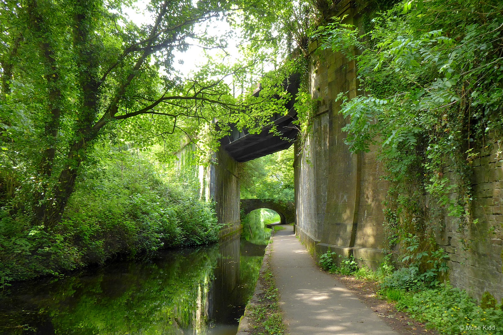
The intersection of the two paths forms a unique bit of engineering; just as the old rail line crosses high above the canal, a small footbridge crosses over the canal and then through the upper bridge. This is the Canal Bridge at Coed-y-Gric which is a Grade II listed building.


Having passed under the bridges and looking back (below). That's NCN Route 492 passing above and I'm now on NCN Route 49 of the Monmouthshire & Brecon Canal.

The canal path then becomes quite interesting as it snakes its way south through several small communities and villages. At one time this section of NCN Route 49 was a terrible muddy single-track and not suitable for cycling, but over the past few years the Canal & River Trust along with local governments; have worked diligently to improve the path between Pontypool and Newport .


Along the way, there are many old remnants of the industrial past — when this was a working canal. This old canal tunnel between Sebastopol and Cwmbran is a well-preserved example and also a Grade II listed structure.

The keyword here is "working" because today the canal is only used by leisure boats toodling along at little more than 2mph. The canal starts 36 miles north in Brecon and here at 5 Locks Basin is the southern terminus for the navigable part of the canal (below).

And to be honest, I find this next section of the canal exceptionally lovely because of the lack of boat traffic. It's quiet, an overgrown wonder... murky, damp, and crawling with life.


Herons stand motionless in the leafy shadows, whilst kingfishers dart under branches overhanging the water, skimming the surface, a flash of colour and gone. The air is thick with the smell of rotting wood, wild garlic, waterlillies, and mystery.


It's nearly 1:00 pm as I entered the next set of locks at Ty Coch. I've traveled just over 23 miles from where I started this morning at Llangattock Escarpment. The temperature is perfect at 17°c. The skies have been cloudy, but I've been under leafy trees for most of the morning. It's a fabulously lazy day and I decide to stop for lunch.

There's a lovely spot off to the side of the canal so I park my bike and pull out a sandwich. Afterwards, I wander around getting all "arty" with my camera.


A group of kids arrive, shouting, excited, ready to let loose, I imagine. So it's time for this old man to go, let the kids have their fun.


I've got my fun too.


I almost didn't include the photo below because the lighting seems a bit unnatural, but that's how it appeared, and yes swans make their nests all long this lower section of the canal path.


As wooded and secluded as this path seems, there are housing estates just along the left side of the canal. Some gardens come down to the waterside, which is exceptionally nice.


The last lock before Newport is rather dangerous. It's a sharp turn along a narrow bridge over the canal... one slight wobble and it's a good 10 foot drop into the cold water below!


Then I'm down to the last boat basin at Newport. The canal goes under the M4 motorway just ahead and beyond that it joins with the Crumlin Branch of the M&B Canal heading up toward 14 Locks (and eventually home).
This is a good place to stop my report. I'm about 17 miles from home, but the rain is finally starting and I'm feeling kinda tired. I'll document the remainder of the ride next time.
This is a good place to stop my report. I'm about 17 miles from home, but the rain is finally starting and I'm feeling kinda tired. I'll document the remainder of the ride next time.
Summary - Llangattock Escarpment Campout
Quite simply, it was great to finally go camping again. The ride up was easy, the weather was good, and the site, though not as secluded as I would have liked, provided spectacular views.
I carried a ridiculous amount of gear for one night, but I tested everything and that was the main point. The little Raleigh performed wonderfully... it is such a surprising joy to ride. NCN Route 492 and NCN Route 49 were beautiful and great fun.
I carried a ridiculous amount of gear for one night, but I tested everything and that was the main point. The little Raleigh performed wonderfully... it is such a surprising joy to ride. NCN Route 492 and NCN Route 49 were beautiful and great fun.
It's been quite a while since I've written a multi-day report. There are many wonderful places to camp in Wales and now that I've checked all my gear, there's nothing holding me back!


If you made it this far... thank you! I hope you enjoyed my little adventure and write-up and that you'll come back to visit Bike Wales again.
Seeya down the road... Cheers! - cm
Seeya down the road... Cheers! - cm