Sometimes you think you know what to expect when re-visiting a previously cycled route. However on this day, I was not prepared for the majesty I was shown in this epic ride back to Brecon.

Overview: Back to Brecon
Date: 24 March 2022
Distance: 84.3 miles / 135.67 kilometres
Elevation: + 5,391 ft / -5,391 ft
Duration: 12 hours, 34 mins.
Distance: 84.3 miles / 135.67 kilometres
Elevation: + 5,391 ft / -5,391 ft
Duration: 12 hours, 34 mins.
Brecon is a special destination for me. Back in 2009, I spent the last night of my first tour of Wales here. It is where, on the following day, I turned south to begin my ride back to the start of my trip. I went there on a lark and loved it.
I remember vivdly the old world charm and medeival character I encountered as I cycled down it's narrow streets. I remember looking fondly at the colourful architecture along the river Usk and my excitement with first discovering the Monmouthshire & Brecon Canal. I was dazzled by the town and now I always look forward to going back.
What I have since discovered, is that getting back to Brecon is an exciting adventure on its own. There are several routes one can take to reach the town from the south; the most obvious being the Taff Trail (NCN Route 8). However, I chose to take the more obscure Cynon Trail (NCN Route 478) all the way to Penderyn before climbing onto the A4059. It is by far the more difficult route to cycle, but it is also the most dramatic as it cuts through the heart of the Brecon Beacons National Park.
And what makes this ride interesting and especially rewarding; is that my return trip comes back from Brecon along the Taff Trail (NCN Route 8) as it climbs above the sparkling Talybont Reservoir.
Once at the top, I then cycle another 10 miles south to Dowlais before turning east across the Heads of the Valley on NCN Route 46. At Tredgar, I finally turn south again on NCN Route 467 to make my way home. It's a classic ride with long stretches on traffic-free paths. It's an epic adventure with many quite lanes and breath-taking high mountain passes. This ride has it all.
Note: The map above includes my entire day of cycling from Oakdale down to Abercynon and then north to Hirwaun. From Hirwaun I continued north to Brecon where I then returned south to Talybont-on-Usk, Pontsticill Reservoir and finally back home across the Heads of the Valley.
PART ONE | Abercynon to Hirwaun | 25.5 miles
Across Penalta Parc via NCN Route 47 to Quakers Yard, down NCN Route 8 (Taff Trail) to Abercynon where I merge onto NCN Route 478 to Hirwaun.
PART TWO | Hirwain to Brecon | 20.8 miles
Continuing on NCN Route 478 from Hirwaun to Pendarren, where I then then merged onto A4059 to the A470 and over the Pen-y-Fan Mountain pass and down into Brecon.
PART THREE | Brecon to Pontsticill | 18.0 miles
Leaving Brecon along the Monmouthshire & Brecon Canal (Taff Trail / NCN Route 8) to Talybont Reservoir, climbing up Valley to Pontsticill Reservoir.
SUMMARY | A Look Back...
Some thoughts and ideas. A sort of round-up, a report card, and my thanks.
PART ONE
| NCN | 47 | 8 | 478 |  |
Abercynon to Hirwaun |
Distance: 25.5 miles / 41.03 kilometres
Elevation: +1219 ft / -1347 ft
Elevation: +1219 ft / -1347 ft
Leaving home, I first cycled down through Blackwood and Pontllanfraith to Gelligroes where I joined NCN Route 47. I continued across the Rhymney Valley via Penalta Parc to Quakers Yard where I then merged onto the Taff Trail (NCN Route 8) for just over a mile south to Abercynon. This is the start of my report.
| ▲ Back to |

Oddly enough, finding the start of the Cynon Trail (NCN Route 478) is a little tricky. One would think that this sign (photo above), which seems to have directions pointing everywhere, might include some sort of indication for the route, but no. It does not.
The Cynon Trail (NCN Route 478) has a very small sign, which is easily missed, just down the hill and behind this junction at the bridge which crosses the River Taff (photo below). It is a weird and confusing lack of detail by Sustrans, in my opinion.
The Cynon Trail (NCN Route 478) has a very small sign, which is easily missed, just down the hill and behind this junction at the bridge which crosses the River Taff (photo below). It is a weird and confusing lack of detail by Sustrans, in my opinion.


Most all rides have modest beginnings and this route is no exception. The first couple of miles are somewhat visually mundane, but easily cycled along quiet lanes or traffic-free cycle paths which closely follow the Afon Cynon River.


 |
| Terence Cuneo’s painting of Trevithick’s famous exploit. |
 |
| photo courtesy of Abercynon History blog |
 |
| photo © Copyright Robin Williams / Geograph |
For more information on Abercynon, I highly recommend visiting: The Abercynon History Blog, also; Richard Trevithick, and the Pennydarren Locomotive.

Once you pass the the Abercynon Sports Centre, the route enters the Pontcynon Industrial Estate. At the far end of the industrial estate and without much fanfare, the Cynon Trail (NCN Route 478) enters the woods and becomes traffic-free for the next three miles.


The path is lovely and quiet as it weaves and rolls alongside the Afon Cynon. You'll be hard-pressed to see a soul.


There are signs of the industrial past as some sections are built upon the old rail line. Whilst new housing developments now share links creating a community pathway.


As you enter the village of Mountain Ash, the route first passes through a small community park before pulling up alongside the very busy A4059.


The route continues as 'shared-use' as it runs beside the road for a couple of miles to Aberdare where it then veers onto a service road which parallels the main road. It's a very busy section with many small businesses, car dealerships, and roundabouts which can be a little tricky to navigate.


Again, it's not very interesting cycling and although the path is slightly more narrow, the route continues to Cynon Valley River Park where it exits the roadway and becomes traffic-free again.


The path starts off along the dark and very quaint Aberdare Canal. After just a mile or so the route passes Aberdare College campus and continues along a small non-descript service road before re-entering the woods.


The path moves through the woods for a short distance before turning to cross directly over the Afon Cynon.

Once across the bridge, the route gets tricky as it enters the roadway again and begins to weave through a small housing estate. This leads to another footbridge; crossing high above the A4059. Once on the other side, a traffic-free path continues a short distance behind yet another housing estate before reaching a very busy roundabout where the cycle path crosses the A4059 again, but at road level.
All of this weaving and crossing takes place within two miles of exiting the Aberdare Canal path. Fortunately though, the route is well-marked and the Cynon Trail (NCN Route 478) signs are quite easy to spot. Good job Sustrans!
All of this weaving and crossing takes place within two miles of exiting the Aberdare Canal path. Fortunately though, the route is well-marked and the Cynon Trail (NCN Route 478) signs are quite easy to spot. Good job Sustrans!
Note: This path is also part of the National Cycle Network so along with the 'Cynon Trail' signs you may see the standard NCN route signs which simply read '478' (shown below).

Now it's time to relax again as I have four miles of easy climbing through the quiet woods high above the Afon Cynon. From here I'll be following the wonderfully smooth, traffic-free cycle path all the way to the sleepy town of Hirwaun.


The route re-enters the road at the bottom of a cul-de-sac just as you enter Hirwaun.
Note: NCN Route 46 crosses and merges with the Cynon Trail (NCN Route 478) for a short distance as you pass through Hirwaun (shown above).
PART TWO
| NCN | 478 | + | ON ROAD |
Hirwaun to Brecon |
Distance: 20.8 miles / 33.47 kilometres
Elevation: +1413 ft / -1606 ft
Elevation: +1413 ft / -1606 ft
Sitting north of the Heads of the Valley motorway and at the southern tip of the Brecon Beacons, the village of Hirwaun feels isolated and alone. The coal mines are shut and the steel works closed. There are no industries left and now Hirwaun is a bedroom community for people who work elsewhere.
As I enter town, I need to navigate several short turns as I first make my way through a housing estate, but Hirwaun is small so it's quite an easy task. The route is well-marked and along the way there are several opportunities to stop for snacks or a comfort break. Then, just after the last turn, the road ends and though not sign-posted, it's clear that the route continues along an unpaved traffic-free path.
As I enter town, I need to navigate several short turns as I first make my way through a housing estate, but Hirwaun is small so it's quite an easy task. The route is well-marked and along the way there are several opportunities to stop for snacks or a comfort break. Then, just after the last turn, the road ends and though not sign-posted, it's clear that the route continues along an unpaved traffic-free path.
| ▲ Back to |

The path is smooth and wide and the finely packed gravel is my favourite surface to cycle upon.


Time for lunch. I've cycled just over 26 miles at this point and it's a gorgeous Spring day. The skies are mostly sunny, whilst the temperature is hovering around 14°c. I couldn't ask for anything better. I am a very fortunate fella to be out exploring Wales on my bike today.


And then before I'm ready for my ride through the woods to end, I re-enter the roadway as I reach the rural village of Penderyn — home of the world famous Penderyn Distillery (mmmm...). This will be the last outpost of civilisation for the next 17 miles.

Because this happens next...


Surprisingly, this is the A4059 again and once it leaves Hirwain, it changes personality completely. I'll follow this road for the next eight miles before merging onto the A470 to cross the mountain pass at Pen-y-Fan.


This is what I love about cycling. Yes, you can see all of this from a car, but when on a bicycle you feel it. I'm not looking at a landscape as I pass through it — I am a part of it.


I stop my bike. I plant my feet on the ground. I turn my head. I look all around.


This is what I see.


I cycle on through the vast open land.


As I continue, I begin to notice that there is a bit of haze over the eastern horizon.


And as I get closer, I can see that there are fires burning on the distant hills...


It's not low-level clouds causing the haze, it's smoke — and surprisingly, I can't smell it.


I carry on and spot some wild horses grazing off to my right, indifferent to the world. I give a whistle though and one girl lifts her head.


Then the road turns north and I begin heading toward the mountain pass at Pen-y-Fan.


The hillside to my left begins to drop away to the Taf Fawr River. I'll be dropping down as well to join the A470 to make the final push to the top (shown below).


Looking south toward Merthyr Tydfil (above). In the distance you can just make out Cantref Reservoir, constructed during the late 19th century to serve Cardiff. It is the middle reservoir of three built along the Taf Fawr River.


I then crossed over the river to join the A470 just below Beacons Reservoir, the smallest and northernmost of the three reservoirs along the Taf Fawr River.


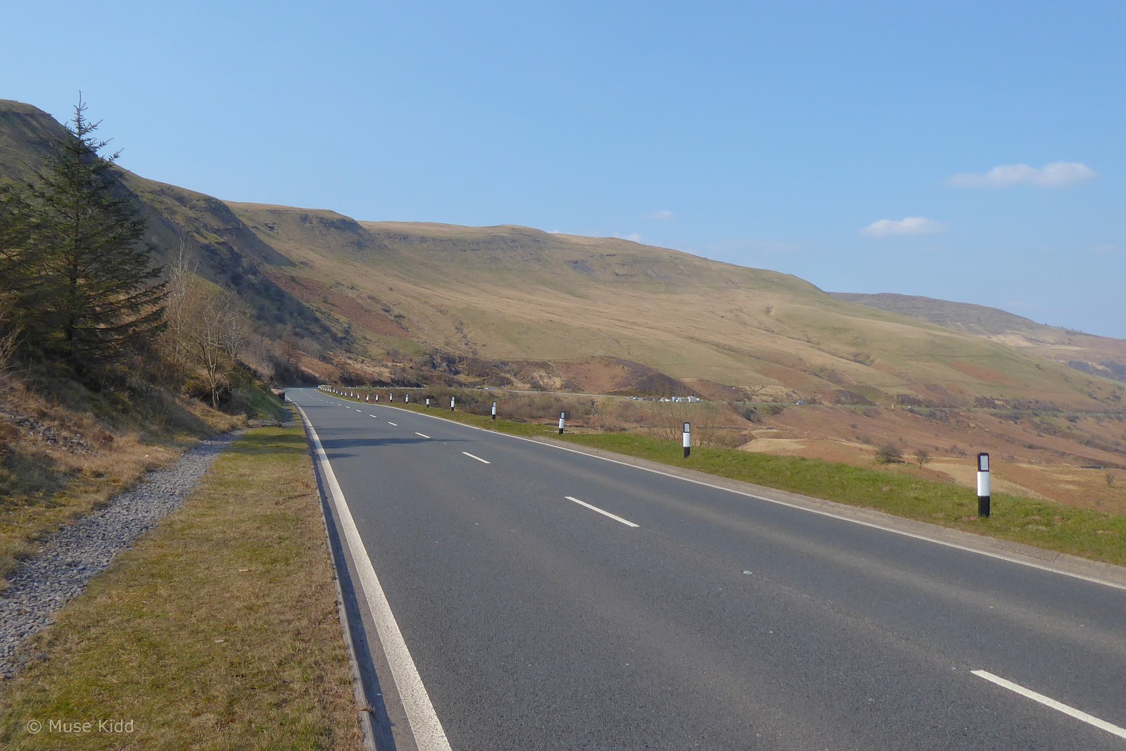
The often very busy A470 is the main road leading over the Pen-y-Fan mountain pass. Cyclists can be seen regularly making this climb and because of this, or perhaps out of respect, motorists were very courteous on this day — giving me plenty of room when passing.
Several folks went so far as to toot their horn, waving and giving me a thumbs-up. I have to say, I found it quite inspiring and it put a smile on my weary face.
Several folks went so far as to toot their horn, waving and giving me a thumbs-up. I have to say, I found it quite inspiring and it put a smile on my weary face.

This is almost the half-way mark on my little adventure. I've cycled just over 36 miles and climbed over 2,300 feet. I've a good way to go yet, but for the next few miles, it's all downhill. My next stop will be the town of Brecon.


I'm racing down the mountain now! I've dropped nearly 400 feet in two miles from the high pass behind me (photo above). Whilst Pen-y-Fan looms large to my right (below).


I can see the town of Brecon in the far distance (above). Another mile further, I reach my exit from the busy A470 and I move onto a quiet country lane as I begin snaking my way deeper toward the valley floor.


The sun is high and bright as I zig-zag my way lower. The temperature is now at a perfect 16°c. I couldn't ask for a better day or better cycling. And nary a car to be seen!


Looking northeast through a 'picture-frame' gap in the hedge, I can see Cribyn Mountain and Pen-y-Fan forming a perfect glacial cirque (photo below).


And then, 'just like that', I was down the mountain and passing through Brecon. I had cycled 46 miles and climbed over 2,600 feet. This was my turning point and I was about halfway. From here I turned south and began my journey home.
Looking back, I don't recall why I didn't take any photos in the town itself? Perhaps I was too excited to finally be in Brecon or just relieved, I dunno? But I rode through without taking a snap until I entered the Taff Trail (NCN Route 8) on the Monmouthshire & Brecon Canal on the eastern outskirts.
Looking back, I don't recall why I didn't take any photos in the town itself? Perhaps I was too excited to finally be in Brecon or just relieved, I dunno? But I rode through without taking a snap until I entered the Taff Trail (NCN Route 8) on the Monmouthshire & Brecon Canal on the eastern outskirts.
 |
| See this in: Google Street View |
 |
| See this in: Google Street View |
 |
| See this in: Google Street View |
 |
| See this in: Google Street View |
 |
| See this in: Google Street View |
 |
| See this in: Google Street View |
As is often the case with using Google Streetview, the time of day and the weather will differ from the day of my ride. Cars and people often affect camera angles, but I've tried to give you a quick snapshot for a sense of the town with it's narrow streets and lovely architecture.
For more information on Brecon, I highly recommend visiting: History of Brecon
For more information on Brecon, I highly recommend visiting: History of Brecon
PART THREE
| NCN | 8 | + | ON ROAD |
Brecon to Pontsticill |
Distance: 18.0 miles / 28.96 kilometres
Elevation: +1593 ft / -935 ft
Elevation: +1593 ft / -935 ft
Brecon to Pontsticill Reservoir
Starting at the canal basin in Brecon, I begin the next leg of my adventure on the Taff Trail (NCN Route 8). I'll follow the canal path for just a short while before exiting onto the roadway and turning toward the mountains again at Brynich Lock.
It's somewhat of a misnomer to call the canal path the Taff Trail here in Brecon, because it is nowhere near the Taff River. Here, we've the Monmouthshire & Brecon Canal and soon the River Usk. To reach the River Taff, I will need to cycle another 15 miles and climb over 1,000 feet into the adjoining Taf Fechan Valley (and that's just what I'ma gonna do!)
It's somewhat of a misnomer to call the canal path the Taff Trail here in Brecon, because it is nowhere near the Taff River. Here, we've the Monmouthshire & Brecon Canal and soon the River Usk. To reach the River Taff, I will need to cycle another 15 miles and climb over 1,000 feet into the adjoining Taf Fechan Valley (and that's just what I'ma gonna do!)
| ▲ Back to |


And the path is lovely. (I'm cycling on my favourite surface again too.) I have another project in the works in which I focus solely on this route from Brecon down to Newport. Hopefully, I'll get that completed in 2023.


But soon I reach my exit at Brynich Lock where I get back onto the road and begin heading up into the hills again.
Pen-y-Fan looms on the horizon (below). I'm heading back that way again, but this time I'll be on the eastern side of the mountain!
Pen-y-Fan looms on the horizon (below). I'm heading back that way again, but this time I'll be on the eastern side of the mountain!
Note: Back in 2009, I could have saved myself a tremendous amount of difficult cycling had I known that you can cycle for 35 miles along the Monmouthshire & Brecon Canal. For some unknown reason, it is not well-publicised, but this path continues along the canal to eventually become NCN Route 49 just outside the village of Crickhowell.


The first village I reach following the Taff Trail (NCN Route 8) is the charming Llanfrynach. I just adore this wonky looking church tower (above) and they even have public toilets for walkers and cyclists alike (below). You'll never see something like this in the US. I always stop and leave a few coins. Thank you volunteers!

But it is the road that is always calling me. This is the B4558 and it's fantastically quiet.


I turn off the B4558 and begin my way up Caerfanell Valley toward Aber Village. It's a slow climb and along the way I pass this pretty cool looking house, so I stop to take a photo (image below). As I'm peering over the hedge and trying to get a good angle with my camera, some guy across the street yells out the window of his house; "hey! you can't take pictures of that... they don't like it!"
I didn't know at the time that this is the Tiratanaloka Buddhist Retreat Centre for Women. I didn't see any signs requesting people to not take photos. (But if I can see it, I can take a picture of it.) So I just looked back at him and shrugged. I could hear him swearing at me as I rode off. My buddy Chris Bleach had a name for those types of people; he called them a "jobsworth". Chris was one of the great ones.
I didn't know at the time that this is the Tiratanaloka Buddhist Retreat Centre for Women. I didn't see any signs requesting people to not take photos. (But if I can see it, I can take a picture of it.) So I just looked back at him and shrugged. I could hear him swearing at me as I rode off. My buddy Chris Bleach had a name for those types of people; he called them a "jobsworth". Chris was one of the great ones.

Blink and you'll miss the village of Aber. Its super cute, but also super small.

Soon after I reached reached the dam at Talybont Reservoir. The late afternoon sun was rather dramatic, so I stopped to take a few photos. Plus, from here I'll crossover onto a rough gravel road for about six miles, so a short break seemed like a good idea.


I rode out onto the dam and leaned my bike against the wall. I knew I needed to be serious about taking these shots because when you're at the right place at the right time, you've got to try your best.

I stayed here for about 45 minutes watching the sun slowly move toward the mountain tops. I adjusted my exposures and tried many different camera angles shooting nearly 50 images to capture the final two shown below. I'm especially proud to say — No filters and No post-production Photoshop™ effects were used.


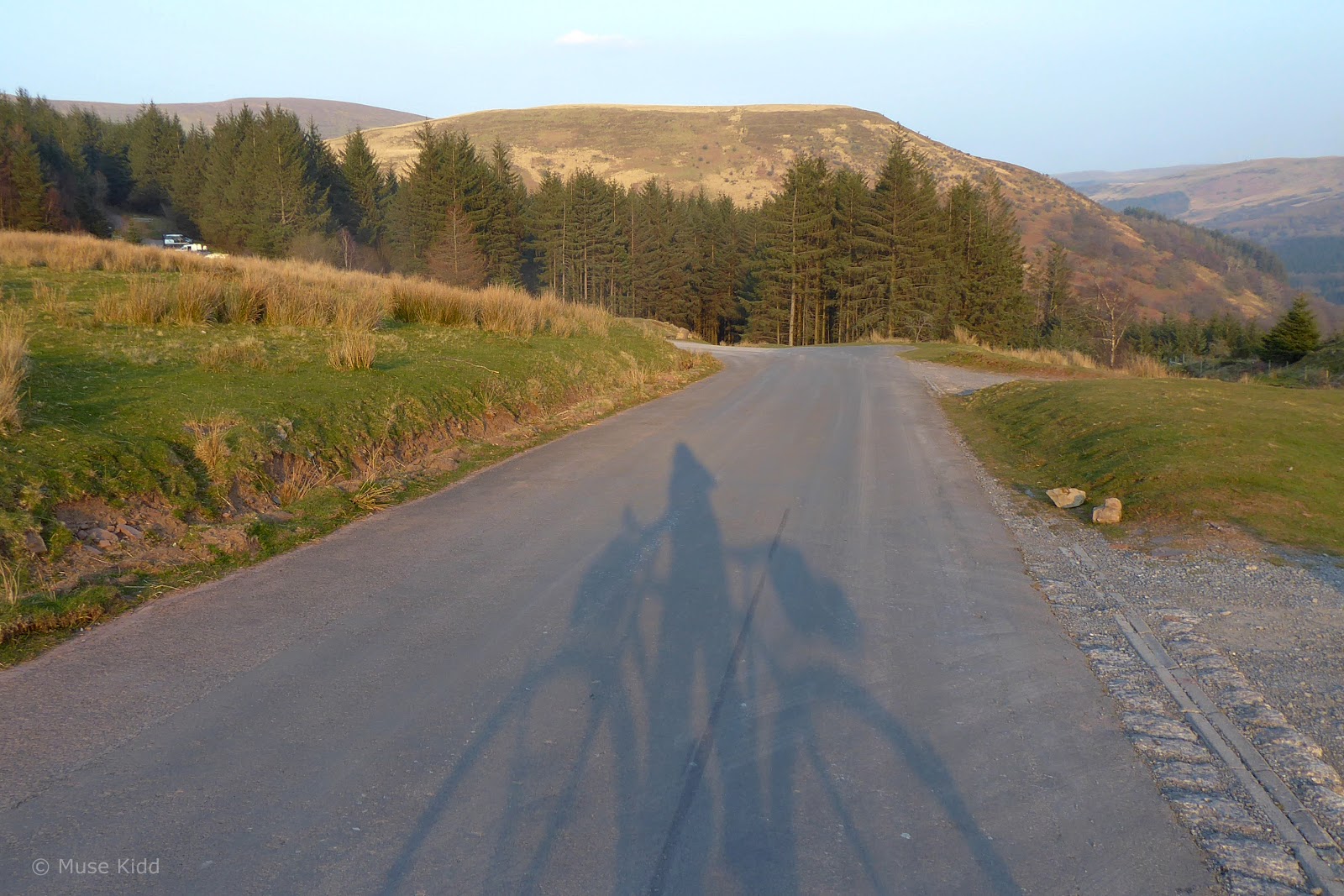
At the far side of the dam, the Taff Trail (NCN Route 8) turns right as it enters Talybont Forest and begins a slow and steady climb of nearly 900 feet in five miles (±4%), all the way to the top of the valley.


Off to my right, Bwlch y Ddwyallt rises proudly over the reservoir as make my way along the gravel forestry road. The afternoon is getting late and the shadows long.


I haven't seen anyone in hours. With the exception of my tyres crunching over the loose gravel, it's absolutely quiet. I've quite a ways to go, but I'm in no hurry.


I pedal on...


I don't know how to describe it exactly, but something happens with me when I'm out here cycling by myself. I'm miles from anywhere and anyone, yet I find myself very relaxed. I am at ease with being alone in nature.


After 45 minutes of steady riding, the bumpy gravel road begins to annoy me. I'm taking photos to take a break. Colloquial title for the image below: "Just point the camera at the sun and see what happens."

And I'm stopping more than I should... just standing and looking at all around me. It is beautiful, but I must press on. I'm not far from the top now.


Typical with many hill climbs in Wales, the last part gets steeper. I pause again to catch my breath and notice a gorge on my left. I must be crossing a culvert burried deep beneath the road. I remember too, that this was once a rail line and passengers traveling between Pontsticill and Talybont-on-Usk shared these amazing views.


Upon exiting the train tunnel, this would be your first views into the Caerfanell Valley. Directly in front is Pen-y-Fan Mountain. Just below that (in the dark valley hidden by the trees) are the famous Caerfanell Waterfalls.


When I look around, I say to myself again; "almost to the top!"


And then I make it! At 1,454 feet, I'm at the highest point along the Taff Trail (NCN Route 8). On my left, you can make out the Pen-y-Fan car park. To my right, is the exit from the forestry road.
It's taken me over an hour to climb nearly 900 feet in five miles (±4%). Which doesn't doesn't sound like much; but for me, on a bumpy, gravel, forestry road; I found it hard work.
It's taken me over an hour to climb nearly 900 feet in five miles (±4%). Which doesn't doesn't sound like much; but for me, on a bumpy, gravel, forestry road; I found it hard work.

In total, I've cycled 60 miles and my climbing is over. From here and practically all the way home, my ride will be downhill. Woohoo!
The only catch is that it's nearly 5:00 pm, the sun is quickly dropping behind the hills and I have 25 miles to go. It will be dark before I reach our back gate.
The only catch is that it's nearly 5:00 pm, the sun is quickly dropping behind the hills and I have 25 miles to go. It will be dark before I reach our back gate.

So with one last look around, I turn to begin my ride home.


As I ride off into the setting sun, I can again see smoke from fires burning on distants hills (photo above). Crazy, weird, and kinda spooky.
Just down the road at Torpantau Railway Station, the Taff Trail (NCN Route 8) exits the main road to follow another gravel forestry road around and down to to a small car park in the Taf Fechan Forest.
Just down the road at Torpantau Railway Station, the Taff Trail (NCN Route 8) exits the main road to follow another gravel forestry road around and down to to a small car park in the Taf Fechan Forest.


It's not really necessary to leave the main road because you soon rejoin it, but it does avoid an exceptionally steep hill and you get a worderful view as you cross the Taf Fechan River.


And then as I dropped down alongside Pontsticill Reservoir, the late afternoon sun rewards me with spectacular lighting. I try to show it justice.


My final shots show how logging has transformed this side of the reservoir.


From Pontsticill I cycled down to Pant where joined NCN Route 46 across the Heads of the Valley to Tredegar and began my ride home.
At Tredegar, I cycled through the lovely Parc Bryn Bach, but it was quickly getting dark and despite the poor exposure and focus, I've included three last images to bookend this report...
At Tredegar, I cycled through the lovely Parc Bryn Bach, but it was quickly getting dark and despite the poor exposure and focus, I've included three last images to bookend this report...


Because dark and blurry sometimes portrays exactly what I'm seeing.
Summary - Back to Brecon
If you made it this far, congratulations! This is a massive read. And to be honest, I didn't realize that I had shot nearly 300 photographs until I began putting the report together (155 photos made the final edit, btw.)
At the beginning, I called this ride epic and for good reasons; it was long and I saw some gorgeous scenery. This was a perfect cycling adventure. The weather was fabulous, I never felt rushed, and the ride was one of my longest for 2022.
At the beginning, I called this ride epic and for good reasons; it was long and I saw some gorgeous scenery. This was a perfect cycling adventure. The weather was fabulous, I never felt rushed, and the ride was one of my longest for 2022.
It was nearing 9:00 pm and well after dark when this old dog stumbled through our back gate. It had been a fantastic day and I was worn out.
I first cycled parts of this route in 2018 (see: Hirwaun & Brecon Loop) and I'm seriously considering it for inclusion in my "Routes to Ride" section. However, I may make it a two-day event with a layover in Brecon. There is just so much to see and spending some time in the town itself is very worthwhile.
(I've also got a slight variation I plan to explore in 2023, so stay tuned!)
I hope you enjoyed my report and thanks for reading!
Seeya down the road... Cheers! - cm
