Few routes are worthy of this dramatic title, but ask most cyclists and they'll likely agree that climbing the highest paved road in Wales; the legendary Gospel Pass, is a ride deserving superlative description as it defines the heart of Bannau Brechieniog.
UPDATED!

Overview: Gospel Pass Epic
Date: May 31, 2016
Distance: 102.1 mi / 164.3 km
Elevation: + 6,489 ft / -6,489 ft
Duration: 15 hours : 38 mins.
Distance: 102.1 mi / 164.3 km
Elevation: + 6,489 ft / -6,489 ft
Duration: 15 hours : 38 mins.
Found between the twin mountains of Twmpa and Hay Bluff at the northern end of the Vale of Ewyas in the Black Mountains of southeast Wales, The Gospel Pass is the highest road pass in all of Wales.
From Llanthony Priory in the south, a small mountain road climbs steeply to a height of 549 metres (1,801 ft) above sea level, ever-narrowing , before dropping down on the far side into the famous book-town of Hay-on-Wye. A popular destination for sightseers and walkers; the pass is one of the most celebrated locations found within the Bannau Brecheiniog National Park. Well-known by cyclists, the Gospel Pass road forms a part of Route 42 of the National Cycle Network.
Our plan was simple and straight-forward. Instead of meeting at our usual starting point in Caerleon, we'd each make our way seperately to Abergavenny and join up by the castle at 7:30 am. From there, our first leg would be to cycle north to Llantony Priory where we would "officially " begin the climb.
Once over the pass, we would drop down to Hay-on-Wye, have some lunch and begin our return via Talgarth, Crickhowell, and then back to Abergavenny making one big loop.
2023 UPDATE: This is an updated version of a previously posted Ride Report. As part of my ongoing redesign of this website, each feature from "Rides to Remember" will be re-formatted to accomodate the new larger page layout. All of the photographs have been re-edited and when needed, the text has been re-edited for context and clarity.
| ROUTE COLOUR KEY: | Traffic-free | Quiet Road | Shared Use | Steep Hill |
Oakdale to Abergavenny
The other Kingfishers loaded their bikes in the back of their cars and drove to Abergavenny. I, on the otherhand - rode my bike.
I left around 5:00 am cycling up Sirhowy Valley to Tredegar, acoss the Heads of the Valley to Brynmawr, and then down through Clydach Gorge to meet the fellas by the castle car park.
I've cycled this route several times and because of this (as well as, the early morning...) I didn't take any photos.
Abergavenny to Hay-on-Wye
For the entire ride from Abergavenny to Hay-on-Wye, we followed NCN Route 42. Thanks to Sustrans, the route is well-marked and despite the many turns through Abergavenny at the start, it is easy to navigate.
However, once out of town on Old Hereford Road, the route becomes a steady climb for the first couple of miles, with one brief section hitting a lung-busting 17% incline. Needless to say, I didn't take any photos until we were well beyond town.
However, once out of town on Old Hereford Road, the route becomes a steady climb for the first couple of miles, with one brief section hitting a lung-busting 17% incline. Needless to say, I didn't take any photos until we were well beyond town.


Six miles out of town we entered the Vale of Ewyas and the rural parish of Cwmyoy where the first notable landmark; Hatterall Ridge is easily spotted as it dominates the eastern hillside (below).

If you look closely, you can see a church along the hillside (above). Often called the most crooked church in the UK, the Church of Saint Martin stands twisted and deformed from years of subsidence. A very thorough description with additional photos can be found here: St Martin's Church, Cwmyoy (Cwmiau), Monmouthshire by John Ball.

We didn't take the time to stop today, but I tried to get a photo of the church from a distance, as well as a few shots of this lovely surrounding valley before the fellas got too far ahead of me. I shall have to make a return visit.


I caught up with the other fellas just before the climb began in earnest. A very kind lady noticed me taking photographs and offere to take this photo of our little group (above). She was quite impressed with our plans, especially when told our ages (l-r, Ivor; 74, John; 66, myself; 56, and Graham; 81!)


Four miles further up the road (just like the sign said!), we did take time to stop at the next interesting church; St Mary's Chapel at Capel-y-ffin. Hidden along side the road behind a thick canopy of fir trees and with no more room for 20 worshippers, this tiny church exudes charm and has a fascinating history.


One more snap of the fellas and we were off again. It was time for the serious stuff.


Not one to be triffled with, John showed his metal and pushed past me. I stopped to take this photo because I thought that I wouldn't see him again until I reached the top (below).

Looking back down the valley, Ivor and Graham were somewhere behind us (above). When I turned back around, sure enough... John was almost out of site up the hill.


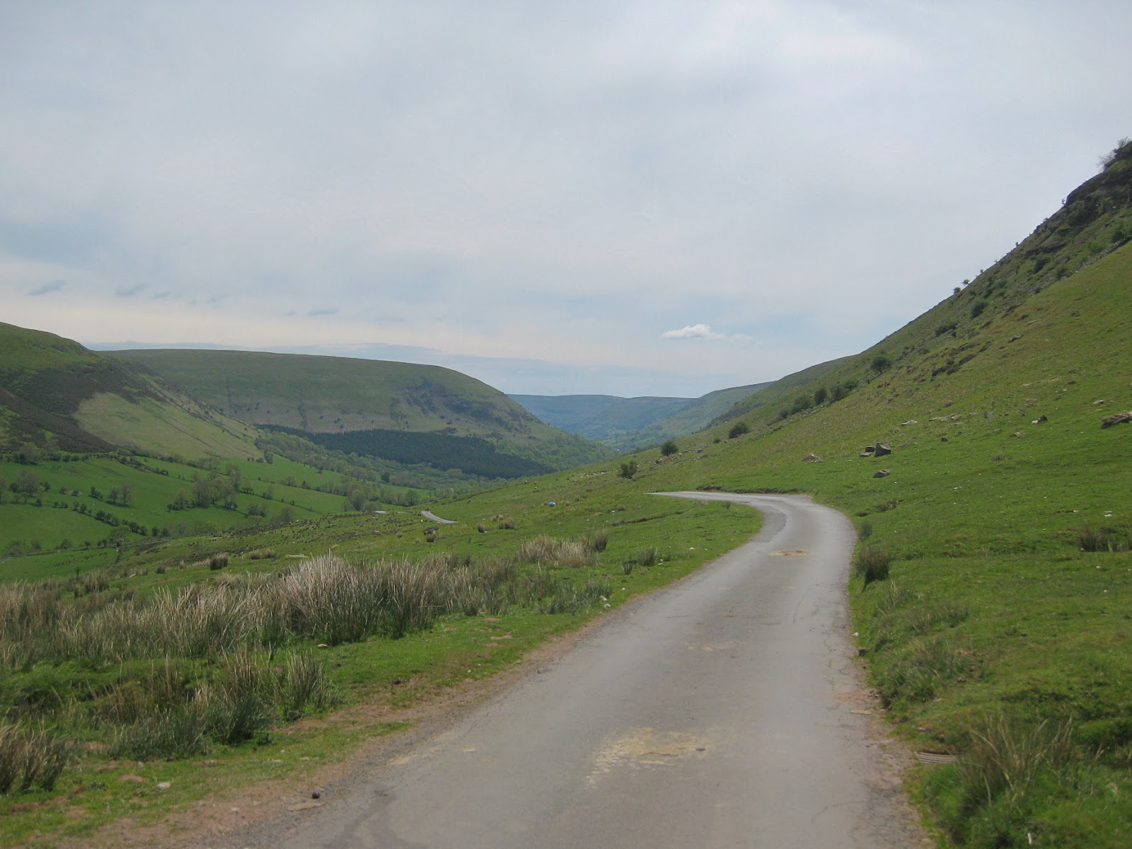
Surpisingly around the next bend, the road levels out slightly and there's a small car park used primarily for folks wanting to hike up Hay Bluff (above).
Looking back again and there's no sign of Ivor or Graham (very worrying). I stopped for a few moments to catch my breath and see if they appeared. The only sound was the wind.
Looking back again and there's no sign of Ivor or Graham (very worrying). I stopped for a few moments to catch my breath and see if they appeared. The only sound was the wind.


From the car park I could now see the summit (above). There was no sign of John, which was a bit worrisome. He has a habit of racing ahead and I hoped that he hadn't carried on down the other side. (Urgh...)
Looking back again, I finally spotted Ivor plugging along in the far distance. However, there was no sign of Graham, which was also worrisome (below).
Looking back again, I finally spotted Ivor plugging along in the far distance. However, there was no sign of Graham, which was also worrisome (below).


Then just as I turned around and began to make my final push to the top... up popped John; waving me on (above). That was a relief! I only had Graham to worry about then.

But before I thought about it too much, I made it to the top. The photo of John says it all (above). Just look at the view.


Directly before us lies the county of Powys and the Kingdom of Hay-on-Wye [sic]. To our west, towers the Twmpa, or more affectionately known as; Lord Hereford's Knob (below).

To our east, the legendary Hay Bluff rises proudly against an azure sky (below).


Ivor arrived (above) and John began to describe our descent (below).


And finally, Graham joined us at the top. Not too shabby for an octogenarian, eh? We were all pretty knackered, but we had done it.
And then it was time for our descent. Just look at that road! (below)
And then it was time for our descent. Just look at that road! (below)

It goes on and on...


I stopped one more time to look back up the road toward the pass (above) and then one more look at Hay Bluff before racing down the mountain (below).


As we rolled into Hay-on-Wye, the town was shockingly busy with pedestrians weaving in and out and all-around the narrow streets. Cars were were trying to squeeze past lorries double-parked as they struggled to unload their wares. It was a morass of activity mixed with a cacophony of sounds as the town was preparing for the Hay Festival.
The change in enviroments could not have been more extreme. I tried to shoot a few photographs, but the fellas were anxious to leave and I was not going to be left behind. We made our way out of town heading south-west toward Talgarth and I shot one last photo looking across to the Black Mountains (above). It had been a full day.
The change in enviroments could not have been more extreme. I tried to shoot a few photographs, but the fellas were anxious to leave and I was not going to be left behind. We made our way out of town heading south-west toward Talgarth and I shot one last photo looking across to the Black Mountains (above). It had been a full day.
Summary - Gospel Pass Epic
Admittedly, I was a little disappointed to not spend more time in Hay-on-Wye. I was quite excited to see all activities, but too, I could understand the fellas desire to get a move on. It was nearing 1:00 pm and it would have taken quite a while to find a place to eat — even if we could have?
We cycled roughly seven miles to Talgarth (which was also rather busy) and found a little cafe for a quick sandwich. After that, we were all pretty quiet for the remaining 20 miles through Cwmdu, Crickhowell, and back into Abergavenny.
This had been a big 50 mile ride. (One of the biggest for Graham and Ivor.) We had done some serious climbing and it had been a great day.
| ROUTE COLOUR KEY: | Traffic-free | Quiet Road | Shared Use | Steep Hill |
Back in Abergavenny, we said our good-byes and went our seperate ways. I still had another 25 miles ahead of me. I didn't shoot any more photos. I just climbed back on my bike and then back up Clydach Gorge to make my way home the same way I had cycled to Abergavenny — nearly 12 hours earlier.
About the update: I've been working on my older/pre-2022 ride preports. The text has been gently massaged to portray a less theatrical feel, whilst all of the images have been re-edited (cropped, exposure adjusted, and sharpened).
I hope you've enjoyed my re-telling of this wonderful adventure. Thanks for visiting.
Cheers! - muse kidd
|
|
|||
| Ride Name: | Gospel Pass Epic | ||
| Start Date: | Tue. May 31, 2016 | ||
| Starts in: | Oakdale, Wales, GB | ||
| Departed: | 06:05 AM | ||
| Distance: | 102.1 mi / 164.3 km | ||
| Elevation: | +6,489 ft / -6,489 ft | ||
| Max Grade: | 13.7% | ||
| Duration: | 15:38:13 | ||
| Move Time: | 09:56:44 | ||
| Stop Time: | 05:41:29 | ||
| Max. Speed: | 31.0 mph | ||
| Avg. Speed: | 10.3 mph | ||
| Weather: | sun/clouds | ||
| Temp: | 20°c / 68°f | ||